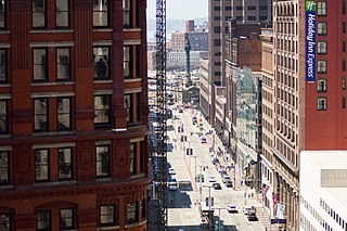
Euclid Avenue is a major street in Cleveland, Ohio, United States. It runs northeasterly from Public Square in Downtown Cleveland, passing Playhouse Square and Cleveland State University, to University Circle, the Cleveland Clinic, Severance Hall, Case Western Reserve University's Maltz Performing Arts Center, Case Western Reserve University and University Hospitals Case Medical Center. The street runs through the suburbs of East Cleveland, Euclid, and Wickliffe, to Willoughby as a part of U.S. Route 20 and U.S. Route 6. The HealthLine bus rapid transit line runs in designated bus lanes in the median of Euclid Avenue from Public Square to Louis Stokes Station at Windermere in East Cleveland.

State Route 11 is a north–south freeway in the northeastern portion of the U.S. state of Ohio. Its southern terminus is at U.S. Route 30 in East Liverpool at the West Virginia state line on the Jennings Randolph Bridge over the Ohio River; its northern terminus is at SR 531 in Ashtabula. The route is concurrent with US 30 through East Liverpool and with Interstate 80 (I-80) near Youngstown. The first section of the route to be completed, from Canfield to Austintown, opened in 1969. The entire current route was complete in 1972, and upgraded to a divided highway by 1980.
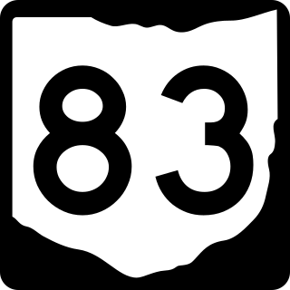
State Route 83 is a north–south state highway in the U.S. state of Ohio. Its southern terminus is near the town of Beverly at State Route 60, and its northern terminus is overlooking Lake Erie at U.S. Route 6 in Avon Lake. A portion of SR 83 is part of the Morgan County Scenic Byway.

State Route 167 is a 14.08-mile-long (22.66 km) east–west state highway in the northeastern portion of the U.S. state of Ohio. Its western terminus is at the northern end of the SR 46 and SR 307 concurrency in Jefferson, and its eastern terminus is at the Pennsylvania state line about 13 miles (21 km) south of Conneaut, where Pennsylvania Route 198 continues east. The route was designated in 1923, and has been rerouted three times since.
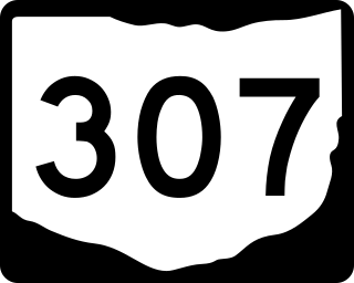
State Route 307 (SR 307) is an east–west state highway in the northeastern portion of the U.S. state of Ohio. Its western terminus is at State Route 528 on the southern boundary of Madison, and its eastern terminus is at State Route 193 nearly 7 miles (11 km) southeast of Jefferson.

State Route 534 (SR 534) is a north–south state highway in the northeastern portion of the U.S. state of Ohio. The southern terminus of SR 534 is at its junction with the duplex of U.S. Route 62 (US 62) and SR 173 nearly 4.50 miles (7.24 km) west of Salem. Its northern terminus is a curve in Geneva-on-the-Lake where the highway directly transitions into SR 531 at that route's western terminus.

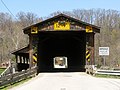
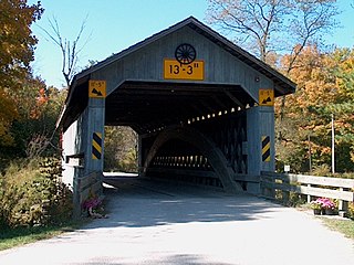
Benetka Road Bridge is a covered bridge spanning the Ashtabula River in Ashtabula County, Ohio, United States. The bridge, one of currently 17 drivable bridges in the county, is a single span Town truss design, with laminated arches being added during its renovation in 1985. The bridge’s WGCB number is 35-04-12, and it is located approximately 4 mi (6.4 km) south of North Kingsville.
Doyle Road Bridge is a covered bridge spanning Mill Creek in Jefferson Township, Ashtabula County, Ohio, United States. The bridge, one of 16 drivable bridges in the county, is a single span Town truss design, with laminated arches added during its renovation in 1987. The bridge’s WGCB number is 35-04-16, and it is located approximately 1.9 mi (3.1 km) north-northwest of Jefferson.

Mechanicsville Road Bridge is a covered bridge spanning the Grand River in Austinburg Township, Ashtabula County, Ohio, United States. The bridge, one of currently 17 drivable bridges in the county, is the longest single span covered bridge in the county, and is believed to be the oldest in the county as well. The bridge is a Howe truss design, with laminated arches added during its renovation in 2003-04. The bridge’s WGCB number is 35-04-18, and it is located approximately 4.3 mi (7.0 km) southeast of Geneva.

Middle Road Bridge is a covered bridge spanning Conneaut Creek in Conneaut, Ashtabula County, Ohio, United States. The bridge, one of currently 16 drivable bridges in the county, is a single span Howe truss design. Built in 1868, it was reconstructed in 1984 with the help of three volunteers and four college students. The bridge’s WGCB number is 35-04-06, and it is located approximately 3.2 mi (5.1 km) south of downtown Conneaut. It is 136 feet long.
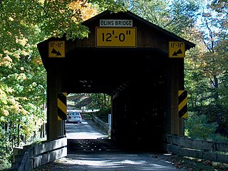
Olin's Bridge, or Olin Bridge, or Olin-Dewey Road Bridge is a covered bridge that carries Dewey Road over the Ashtabula River in Plymouth Township, Ashtabula County, Ohio, United States. The bridge, one of currently 16 drivable bridges in the county, is a single span Town truss design, and is currently the only bridge in the county named for a family. The Olin family has owned property next to the bridge since it was built. Members of the Olin family also operate a small museum and gift shop just east of the bridge at the house previously owned by Joyce Grandbouche. The bridge’s WGCB number is 35-04-03, and it is located approximately 3.6 mi (5.7 km) east of Ashtabula.

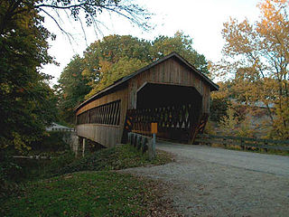
Riverdale Road Bridge is a covered bridge spanning the Grand River in Morgan Township, Ashtabula County, Ohio, United States. The bridge, one of currently 16 drivable bridges in Ashtabula county, is a single span Town truss design. During its renovation in 1981, the floor was rebuilt and glue-laminated wood girders were added. Previously, center steel bracing had been replaced under the bridge in 1945. In 1987, a new concrete abutment for additional support was added after the road at the east end of the bridge washed out. The bridge’s WGCB number is 35-04-22, and it is located approximately 1.1 mi (1.8 km) north-northwest of Rock Creek.

Root Road Bridge is a covered bridge spanning the west branch of the Ashtabula River in Monroe Township, Ashtabula County, Ohio, United States. The bridge, one of currently 16 drivable bridges in the county, is a single span Town truss design. During its renovation in 1982-83, the bridge was raised 18 inches (460 mm), and a new center pier was added. The bridge’s WGCB number is 35-04-09, and it is located approximately 6.3 mi (10.1 km) southeast of North Kingsville.
South Denmark Road Bridge is a covered bridge spanning Mill Creek in Denmark Township, Ashtabula County, Ohio, United States. The bridge, one of currently 16 drivable bridges in the county, is a single span Town truss design. Bypassed in 1975, the bridge still remains open to light traffic. The bridge’s WGCB number is 35-04-14, and it is located approximately 4.4 mi (7.1 km) east-southeast of Jefferson.
State Road Bridge is a covered bridge spanning Conneaut Creek in Monroe Township, Ashtabula County, Ohio, United States. The bridge, one of currently 17 drivable bridges in the county, is a single span Town truss design. Constructed of 97,000 feet (30,000 m) of southern pine and oak, it features a 4-foot-tall (1.2 m) window which extends the length of the bridge. The dedication of the bridge in 1983 was the forerunner of the Ashtabula County Covered Bridge Festival. The bridge’s WGCB number is 35-04-58, and it is located approximately 3.9 miles (6.3 km) east-southeast of North Kingsville.

Windsor Mills Bridge, also known as Wiswell Road Bridge or Warner Hollow Road Bridge, is a covered bridge that carries Covered Bridge Lane, formerly Wiswell Road, across Phelps Creek in Windsor Township, Ashtabula County, Ohio, United States. The bridge, one of currently 17 drivable bridges in the county, is a single-span Town truss design. The bridge was built in 1867 using white pine. It sits atop cut stone abutments, one made of sandstone quarried nearby, and the other made of creek stone. The bridge was bypassed in the 1960s and closed to traffic, and Wiswell Road was rerouted west of the creek. In the 1980s, the bridge was completely closed due to safety reasons. It underwent extensive renovation from 2002 to 2004, and was then reopened to all traffic, except for trucks and buses. The bridge is listed in the National Register of Historic Places. The bridge's WGCB number is 35-04-25, and it is located approximately 5.0 mi (8.0 km) west of Orwell.

U.S. Route 50 runs east–west across the southern part of the state of Ohio, passing through Cincinnati, Chillicothe, and Athens. It is mainly a two-lane road except for the easternmost and westernmost parts. Near Athens it runs concurrently with State Route 32 (SR 32), a four-lane divided highway known as Corridor D, and from Coolville to the Ohio–West Virginia border it also overlaps SR 7 before crossing into Parkersburg, West Virginia.

Old Blenheim Bridge was a wooden covered bridge that spanned Schoharie Creek in North Blenheim, New York, United States. With an open span of 210 feet (64 m), it had the second longest span of any surviving single-span covered bridge in the world. The 1862 Bridgeport Covered Bridge in Nevada County, California, currently undergoing repairs due to 1986 flooding is longer overall at 233 feet (71 m) but is argued to have a 208 feet (63 m) clear span. The bridge, opened in 1855, was also one of the oldest of its type in the United States. It was destroyed by flooding resulting from Tropical Storm Irene in 2011. Rebuilding of the bridge commenced in 2017 and was completed in 2018.

U.S. Route 23 (US 23) is a United States Numbered Highway that runs from Jacksonville, Florida, to Mackinaw City, Michigan. In the state of Ohio, it is a major north–south state highway that runs from the Kentucky border at Portsmouth to the Michigan border at Sylvania.