
Marietta is a city in, and the county seat of, Washington County, Ohio, United States. It is located in southeastern Ohio at the confluence of the Muskingum and Ohio Rivers, 11 miles (18 km) northeast of Parkersburg, West Virginia. As of the 2020 census, Marietta has a population of 13,385 people. It is the principal city of the Marietta micropolitan area, which includes all of Washington County, and is the second-largest city in the Parkersburg–Marietta–Vienna combined statistical area.

Coal Run is an unincorporated community in northeastern Waterford Township, Washington County, Ohio, United States. It has a post office with the ZIP code 45721. It is located along State Route 60 between the villages of Beverly and Lowell. The Muskingum River flows past the community.
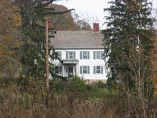
The Adams–Gray House is a historic farmhouse in the community of Adams Mills, Ohio. Constructed in the 1840s in two separate counties, it has been named a historic site.
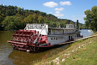
W. P. Snyder Jr., also known as W. H. Clingerman, W. P. Snyder Jr. State Memorial, or J. L. Perry, is a historic towboat moored on the Muskingum River in Marietta, Ohio, at the Ohio River Museum. A National Historic Landmark, she is the only intact, steam-driven sternwheel towboat still on the nation's river system.

This is a list of the National Register of Historic Places listings in Muskingum County, Ohio.

This is a list of the National Register of Historic Places listings in Perry County, Ohio.
Harmar is a historic neighborhood in the city of Marietta, Ohio, United States. Located at the western side of the confluence of the Muskingum and Ohio Rivers, it grew up around the early Fort Harmar in the 1780s, being settled in conjunction with Marietta. After a period of forming part of Marietta, it existed separately beginning in 1837 before rejoining the mother city in 1890. Connected by bridge to the rest of the city, it retains much of its nineteenth-century architecture and landscape, and most of the neighborhood is now a historic district on the National Register of Historic Places.

The Ohio Company Land Office is one of the original buildings of the city of Marietta, Ohio, United States. The Office is listed individually in the National Register of Historic Places and as a contributing property to the Marietta Historic District.
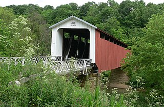
The Hildreth Covered Bridge, also known as the "Hills Covered Bridge" or "Lafaber's Mill Bridge," is a historic covered bridge in Washington County, Ohio, United States. Located off State Route 26 in Newport Township, about 5 miles (8.0 km) east of the city of Marietta, the bridge historically carried Hills Bridge Road over the Little Muskingum River. Construction of the Hildreth Bridge was a long process: the most significant amount of work was done on the bridge in 1878, but the entire construction process occurred between 1871 and 1881. The identity of its builder is unknown.

The Colonel Joseph Barker House is a historic residence in Washington County, Ohio, United States. Located north of Marietta, in the Muskingum Township community of Devola, it has changed little since its construction in the early nineteenth century, and it has been designated a historic site.

The Judge Joseph Barker House is a historic residence in southern Washington County, Ohio, United States. Located along State Route 7 southwest of the community of Newport, it is a brick structure with a roof of metal, a foundation of sandstone, and other elements of wood and metal. Constructed in 1832, it is a two-story rectangular building that sits atop an Ohio River bluff. Its floor plan is five bays wide, featuring a central entrance with a fanlight and sidelights.

The Jonathan Sprague House is a historic residence in northwestern Washington County, Ohio, United States. Located atop a bluff above the Muskingum River, it is one of Washington County's most significant houses, due to its age and method of construction.

The Spring Street Historic District encompasses surviving elements of the 19th-century commercial and surviving residential areas of Portland, Maine. Encompassing a portion of the city's Arts District and an eastern portion of its West End, the district has a significant concentration of residential and commercial buildings that survived the city's devastating 1866 fire. The district was listed on the National Register of Historic Places in 1970.

The First Unitarian Church of Marietta is a historic Unitarian Universalist church in the city of Marietta, Ohio, United States. Founded in 1869, it uses a building constructed in 1858 for one of its two predecessor churches; this building's high-quality architecture has led to its designation as a historic site.
The Federal Street Historic District of Brunswick, Maine encompasses a part of the town whose development was influenced by its 18th-century success as a shipping center, and by the presence of Bowdoin College, whose historic central campus is part of the district. In addition to the campus, the district includes a series of relatively high-style Federal and later-period houses along Federal Street and Maine Street, which join the campus to downtown Brunswick. The district was listed on the National Register of Historic Places in 1976.
The Jericho Rural Historic District encompasses a rural agricultural landscape of northern Hartford, Vermont, extending slightly into neighboring Norwich. The area covers 774 acres (313 ha) of mainly agricultural and formerly agricultural lands, as well as associated woodlots, and includes nine historically significant farm complexes. It was listed on the National Register of Historic Places in 2001.
The Jericho Village Historic District encompasses the historic industrial and commercial center of the village of Jericho, Vermont. Stretched along Vermont Route 15 south of Browns River, which powered the village's industries for many years, the village center includes a well-preserved array of 19th and early 20th-century buildings. The district was listed on the National Register of Historic Places in 1992.

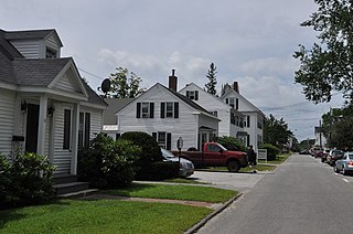
The Portsmouth Downtown Historic District encompasses the historic urban core of Portsmouth, New Hampshire. With a history dating to the 17th century, Portsmouth was New Hampshire's principal seaport and the center of its economy for many decades, and the architecture of its urban center is reflective of nearly four centuries of history. The district is roughly L-shaped, radiating from the downtown Market Square area to South Street in the south and Madison and Columbia streets in the west, with more than 1,200 historically significant buildings. It was listed on the National Register of Historic Places in 2017. The district includes 35 previous listings on the National Register, and five National Historic Landmarks.

The West End North Historic District encompasses a neighborhood of late 19th and early 20th century residential architecture in western Hartford, Connecticut and eastern West Hartford, Connecticut. Roughly bounded by Prospect, Elizabeth, and Lorraine Streets and Farmington Avenue, the area includes a large number of Colonial Revival and Queen Anne houses, as well as numerous buildings in other period styles, with only a small number of losses. It was listed on the National Register of Historic Places in 1985.
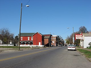
Putnam Historic District, located in Zanesville, Ohio, was an important center of Underground Railroad traffic and it home to a number of abolitionists. The district, with private residences and other key buildings important in the fight against slavery, lies between the Pennsylvania Central Railroad, Van Buren Street, and Muskingum River. It became a historic district of the National Register of Historic Places in 1975.


