
Obsidian is a naturally occurring volcanic glass formed when lava extruded from a volcano cools rapidly with minimal crystal growth. It is an igneous rock.

Yellowstone National Park is a national park located in the western United States, largely in the northwest corner of Wyoming and extending into Montana and Idaho. It was established by the 42nd U.S. Congress with the Yellowstone National Park Protection Act and signed into law by President Ulysses S. Grant on March 1, 1872. Yellowstone was the first national park in the U.S. and is also widely held to be the first national park in the world. The park is known for its wildlife and its many geothermal features, especially the Old Faithful geyser, one of its most popular. While it represents many types of biomes, the subalpine forest is the most abundant. It is part of the South Central Rockies forests ecoregion.

The geothermal areas of Yellowstone include several geyser basins in Yellowstone National Park as well as other geothermal features such as hot springs, mud pots, and fumaroles. The number of thermal features in Yellowstone is estimated at 10,000. A study that was completed in 2011 found that a total of 1,283 geysers have erupted in Yellowstone, 465 of which are active during an average year. These are distributed among nine geyser basins, with a few geysers found in smaller thermal areas throughout the Park. The number of geysers in each geyser basin are as follows: Upper Geyser Basin (410), Midway Geyser Basin (59), Lower Geyser Basin (283), Norris Geyser Basin (193), West Thumb Geyser Basin (84), Gibbon Geyser Basin (24), Lone Star Geyser Basin (21), Shoshone Geyser Basin (107), Heart Lake Geyser Basin (69), other areas (33). Although famous large geysers like Old Faithful are part of the total, most of Yellowstone's geysers are small, erupting to only a foot or two. The hydrothermal system that supplies the geysers with hot water sits within an ancient active caldera. Many of the thermal features in Yellowstone build up sinter, geyserite, or travertine deposits around and within them.

Devils Postpile National Monument is a U.S. National Monument located near Mammoth Mountain in Eastern California. The monument protects Devils Postpile, an unusual rock formation of columnar basalt, "all closely and perfectly fitted together like a vast mosaic." The monument encompasses 798 acres (323 ha) and includes two main attractions: the Devils Postpile formation and Rainbow Falls, a waterfall on the Middle Fork of the San Joaquin River. In addition, the John Muir Trail and Pacific Crest Trail merge into one trail as they pass through the monument. Excluding a small developed area containing the monument headquarters, visitor center and a campground, the National Monument lies within the borders of the Ansel Adams Wilderness.

The Mono–Inyo Craters are a volcanic chain of craters, domes and lava flows in Mono County, Eastern California. The chain stretches 25 miles (40 km) from the northwest shore of Mono Lake to the south of Mammoth Mountain. The Mono Lake Volcanic Field forms the northernmost part of the chain and consists of two volcanic islands in the lake and one cinder cone volcano on its northwest shore. Most of the Mono Craters, which make up the bulk of the northern part of the Mono–Inyo chain, are phreatic volcanoes that have since been either plugged or over-topped by rhyolite domes and lava flows. The Inyo volcanic chain form much of the southern part of the chain and consist of phreatic explosion pits, and rhyolitic lava flows and domes. The southernmost part of the chain consists of fumaroles and explosion pits on Mammoth Mountain and a set of cinder cones south of the mountain; the latter are called the Red Cones.
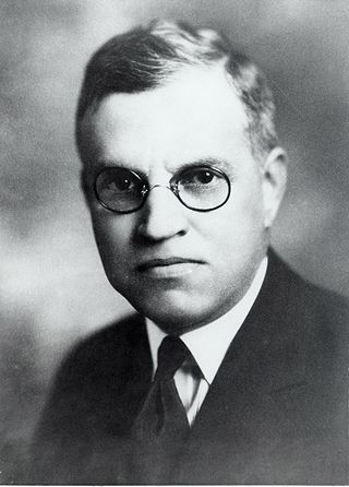
Robert Chambers Reamer (1873–1938) was an American architect, most noted for the Old Faithful Inn in Yellowstone National Park. A number of his works are listed on the National Register of Historic Places for their architecture.

The Norris, Madison, and Fishing Bridge Museums are three "trailside museums" within Yellowstone National Park in the western United States. Built in 1929 to designs by Herbert Maier, they are preeminent early examples of the National Park Service Rustic style of architecture, and served as models for the construction of park buildings elsewhere in the park system in the 1930s. They were collectively designated a National Historic Landmark in 1987.
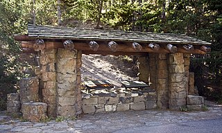
The Obsidian Cliff Kiosk is a small structure that shelters an interpretive exhibit in Yellowstone National Park at Obsidian Cliff. The kiosk was built in 1931 as part of an effort to provide interpretive exhibits along the park's Grand Loop Road. In common with the Fishing Bridge Museum, Madison Museum and Norris Museum, the kiosk exemplifies the National Park Service Rustic style. The interpretive exhibit was designed by National Park Service's Carl Russell, who provided many other innovations in visitor experiences.

The Grand Loop Road is a historic district which encompasses the primary road system in Yellowstone National Park. Much of the 140-mile (230 km) system was originally planned by Captain Hiram M. Chittenden of the US Army Corps of Engineers in the early days of the park, when it was under military administration. The Grand Loop Road provides access to the major features of the park, including the Upper, Midway and Lower geyser basins, Mammoth Hot Springs, Tower Fall, the Grand Canyon of the Yellowstone and Yellowstone Lake.

The Lake Fish Hatchery Historic District comprises nine buildings built between 1930 and 1932 by the U.S. Fish and Wildlife Service in the National Park Service Rustic style. The buildings exhibit a consistency of style and construction, with exposed gable trusses and oversized paired logs at the corners, all with brown paint. The district is located on the shore of Yellowstone lake near the Lake Hotel The hatchery was established to provide Yellowstone cutthroat trout eggs for state and federal hatcheries outside Yellowstone.

The Mammoth Hot Springs Historic District is a 158-acre (64 ha) historic district in Yellowstone National Park comprising the administrative center for the park. It is composed of two major parts: Fort Yellowstone, the military administrative center between 1886 and 1918, and now a National Historic Landmark, and a concessions district which provides food, shopping, services, and lodging for park visitors and employees. It was added to the National Register of Historic Places on March 20, 2002, for its significance in architecture, conservation, entertainment/recreation, and military. The district includes 189 contributing buildings.

The North Entrance Road Historic District comprises Yellowstone National Park's North Entrance Road from Gardiner, Montana to the park headquarters at Mammoth Hot Springs, Wyoming, a distance of a little over five miles (8 km). The North Entrance Road was the first major road in the park, necessary to join the U.S. Army station at Fort Yellowstone to the Northern Pacific Railroad station at Gardiner. The road includes the Roosevelt Arch at the northern boundary of the park and winds through rolling terrain before crossing the Gardner River and joining the Grand Loop Road.

The Gardner River is a tributary of the Yellowstone River, approximately 25 miles (40 km) long, in northwestern Wyoming and south central Montana in the United States. The entire river is located within Yellowstone National Park. It rises on the slope of Joseph Peak, Gallatin Range in the northwestern part of the park, and winds southeast through Gardner's Hole, a broad subalpine basin which is a popular trout fishing location. The Gardner falls within the Native Trout Conservation Area and anglers are allowed to take an unlimited number of brown and rainbow trout. Mountain whitefish and Yellowstone cutthroat trout must be released. Angling on the Gardner is governed by Yellowstone National Park fishing regulations. After merging with Panther Creek, Indian Creek and Obsidian Creek, it then turns north and flows through a steep canyon where it cuts through a basaltic flow from approximately 500,000 years ago known as Sheepeater Cliffs. Below Sheepeater, Glen Creek out of Golden Gate Canyon and Lava Creek out of Lava Creek Canyon join the Gardner near Mammoth Hot Springs. The river crosses the 45th parallel in Gardner Canyon and is also home to a popular hot spring known as The Boiling River. The river continues north through Gardner Canyon and empties into the Yellowstone near Gardiner, Montana.

The following articles relate to the history, geography, geology, flora, fauna, structures and recreation in Yellowstone National Park.

This is a list of the National Register of Historic Places listings in Park County, Wyoming.

Roaring Mountain is in Yellowstone National Park in the U.S. state of Wyoming. Roaring Mountain was named for the numerous fumaroles on the western slope of the peak which during the early 1900s were loud enough to be heard for several miles. Roaring Mountain is 5 miles (8.0 km) north of Norris Geyser Basin and south of Obsidian Cliff and is easily seen from park roads.

Golden Gate Canyon is in the northwestern region of Yellowstone National Park in the U.S. state of Wyoming. Glen Creek flows north through the canyon en route to the Gardner River descending from 7,400 feet (2,300 m) at Kingman Pass to just under 6,000 feet (1,800 m) in less than 3 miles (4.8 km). The northern portion of the Grand Loop Road traverses the canyon, connecting Mammoth Hot Springs with park features to the south.
This is a list of the National Register of Historic Places listings in Yellowstone National Park.
Indian Mound Reserve is a public country park near the village of Cedarville, Ohio, United States. Named for two different earthworks within its bounds — the Williamson Mound and the Pollock Works — the park straddles Massies Creek as it flows through a small canyon.

Imhoff Archeological Site, also known as Site 23CP7, is a historic archaeological site located near Blackwater, Cooper County, Missouri. It is a Middle Woodland Period village site situated on a terrace in the Lamine River locality of the Missouri River Valley. The pottery and stone tools from the site belong to the technological/artistic tradition that is described as "Hopewell." The site was discovered by J. Mett Shippee in the 1930s. Marvin Kay surveyed the site and conducted very limited testing during 1971. No radiocarbon dates are available for the site. A sample of obsidian from the Imhoff site, in the George C. Nicholas collection, has been analyzed using Neutron Activation Analysis. The obsidian from the Imhoff site can be traced to the obsidian cliff in Yellowstone National Park, Wyoming.


