Āria

Last updated • 2 min readFrom Wikipedia, The Free Encyclopedia

Āria
Village
Aria
Coordinates: 38°33′41″S174°59′07″E / 38.56139°S 174.98528°E / -38.56139; 174.98528 Coordinates: 38°33′41″S174°59′07″E / 38.56139°S 174.98528°E / -38.56139; 174.98528
Country New Zealand
Region Waikato region
District Waitomo District
WardWaitomo Rural Ward
Electorate Taranaki-King Country
Government
  Territorial Authority Waitomo District Council
  Regional council Waikato Regional Council
Population
 (2018 Census)
  Territorial129
Time zone UTC+12 (NZST)
  Summer (DST) UTC+13 (NZDT)

Āria is a rural community in the Waitomo District and Waikato region of New Zealand's North Island. [1]

Contents

The area experienced severe flooding in September 2017. [2] [3]

History

Āria began in 1904, when some 30 blocks of around 200 acres (81 ha) [4] were given under the Homestead Acts. [5] Four small mines produced 53,000 tons from Aria coalfield between 1917 and 1961. [6] To the east of Āria [7] a lime quarry opened in the 1960s. [8] A new post office opened in 1922 [9] and there was a butter factory [10] from about 1911. [11]

Demographics

Āria statistical area, which also includes Piopio, covers 531.79 km2 (205.33 sq mi) [12] and had an estimated population of 1,300 as of June 2022, [13] with a population density of 2.4 people per km2.

Historical population
YearPop.±% p.a.
20061,359    
20131,194−1.83%
20181,290+1.56%
Source: [14]

Āria had a population of 1,290 at the 2018 New Zealand census, an increase of 96 people (8.0%) since the 2013 census, and a decrease of 69 people (−5.1%) since the 2006 census. There were 462 households, comprising 654 males and 636 females, giving a sex ratio of 1.03 males per female. The median age was 35.8 years (compared with 37.4 years nationally), with 324 people (25.1%) aged under 15 years, 237 (18.4%) aged 15 to 29, 567 (44.0%) aged 30 to 64, and 165 (12.8%) aged 65 or older.

Ethnicities were 76.5% European/Pākehā, 36.3% Māori, 1.4% Pacific peoples, 1.4% Asian, and 0.9% other ethnicities. People may identify with more than one ethnicity.

The percentage of people born overseas was 8.4, compared with 27.1% nationally.

Although some people chose not to answer the census's question about religious affiliation, 58.1% had no religion, 25.1% were Christian, 4.7% had Māori religious beliefs, 0.2% were Hindu, 0.2% were Muslim, 0.2% were Buddhist and 1.2% had other religions.

Of those at least 15 years old, 126 (13.0%) people had a bachelor's or higher degree, and 225 (23.3%) people had no formal qualifications. The median income was $29,900, compared with $31,800 nationally. 108 people (11.2%) earned over $70,000 compared to 17.2% nationally. The employment status of those at least 15 was that 513 (53.1%) people were employed full-time, 210 (21.7%) were part-time, and 30 (3.1%) were unemployed. [14]

Āria community is in meshblocks 1014500, 1014600, 1014900 and 1015000, which had a population of 129 in the 2018 census. [15]

Education

Āria School is a co-educational state primary school, [16] [17] with a roll of 39 as of November 2022. [18] [19] The school was established in 1908. [20]

Related Research Articles

<span class="mw-page-title-main">Ngāruawāhia</span> Town in Waikato, New Zealand

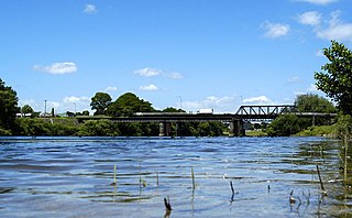
Ngāruawāhia is a town in the Waikato region of the North Island of New Zealand. It is located 20 kilometres (12 mi) north-west of Hamilton at the confluence of the Waikato and Waipā Rivers, adjacent to the Hakarimata Range. Ngāruawāhia is in the Hamilton Urban Area, the fourth largest urban area in New Zealand. The location was once considered as a potential capital of New Zealand.

<span class="mw-page-title-main">Te Awamutu</span> Town in Waikato, New Zealand

Te Awamutu is a town in the Waikato region in the North Island of New Zealand. It is the council seat of the Waipa District and serves as a service town for the farming communities which surround it. Te Awamutu is located some 30 kilometres (19 mi) south of Hamilton on State Highway 3, one of the two main routes south from Auckland and Hamilton.

<span class="mw-page-title-main">Tīrau</span> Settlement in Waikato, New Zealand

Tīrau is a small town in the Waikato region of the North Island of New Zealand, 50 kilometres southeast of Hamilton. The town has a population of 804. In the Māori language, "Tīrau" means "place of many cabbage trees."

Ruakura is a semi-rural suburb of Hamilton City, in the Waikato region of New Zealand. The University of Waikato is nearby.

<span class="mw-page-title-main">Kawhia Harbour</span> Harbour and settlement in Waikato, New Zealand

Kawhia Harbour is one of three large natural inlets in the Tasman Sea coast of the Waikato region of New Zealand's North Island. It is located to the south of Raglan Harbour, Ruapuke and Aotea Harbour, 40 kilometres southwest of Hamilton. Kawhia is part of the Ōtorohanga District Council and is in the King Country. It has a high-tide area of 68 km2 (26 sq mi) and a low-tide area of 18 km2 (6.9 sq mi). Te Motu Island is located in the harbour.

<span class="mw-page-title-main">Putāruru</span> Town in Waikato, New Zealand

Putāruru is a small town in the South Waikato District and the Waikato region of New Zealand's North Island. It lies on the western side of the Mamaku Ranges and in the upper basin of the Waihou River. It is on the Oraka Stream 65 kilometres south-east of Hamilton. State Highway 1 and the Kinleith Branch railway run through the town.

<span class="mw-page-title-main">Frankton, Hamilton</span> Suburb of Hamilton, New Zealand

Frankton is a central suburb of the city of Hamilton, New Zealand. It is the site of the city's passenger railway station, a major industrial-commercial stretch of State Highway 1, and a commercial shopping area. Frankton Borough Council was formed in 1913, but merged with Hamilton in 1917, after a poll in 1916.

<span class="mw-page-title-main">Te Rapa</span> Suburb of Hamilton, New Zealand

Te Rapa is a mixed light industrial, large-scale retail and semi-rural suburb to the northwest of central Hamilton, New Zealand that is built on a flat area that was previously the bed of an ancient river, the forerunner to the present Waikato River.

<span class="mw-page-title-main">Flagstaff, Hamilton</span> Suburb of Hamilton, New Zealand

Flagstaff is a suburb in north-east Hamilton, New Zealand. It was originally called Dulverton on council plans, but it was officially named Flagstaff in 1986 when it was declared as a suburb. The area was heavily developed in the 1990s.

<span class="mw-page-title-main">Rototuna</span> Suburb of Hamilton, New Zealand

Rototuna is a suburb in northern Hamilton, New Zealand, east of Flagstaff. It is one of the newest and fastest-growing suburbs in Hamilton, along with neighbouring Huntington and Flagstaff.

<span class="mw-page-title-main">Hinuera</span> Settlement in Waikato, New Zealand

Hinuera is a settlement in the Waikato Region of New Zealand's North Island. It is located along State Highway 29, approximately halfway between the cities of Hamilton and Tauranga. It also contains the Hinuera cliffs along State Highway 29.

<span class="mw-page-title-main">Te Pahu</span> Settlement in Waikato, New Zealand

Te Pahu is a rural community in the Waipa District and Waikato region of New Zealand's North Island, located just north of Cambridge across State Highway 1.

<span class="mw-page-title-main">Enderley</span> Suburb of Hamilton, New Zealand

Enderley is a suburb of Hamilton, New Zealand. It became a part of Hamilton in the 5th boundary extension in 1949. It is the highest ranking suburb for socio-economic deprivation in eastern Hamilton.

<span class="mw-page-title-main">Whitiora</span> Suburb of Hamilton, New Zealand

Whitiora is a suburb in central Hamilton in New Zealand. The suburb is home to Waikato Stadium, formerly Rugby Park. It is a major sporting and cultural events venue in Hamilton with a total capacity of 25,800. The stadium is a multi-purpose facility, though used mainly for rugby union. Many of Hamilton's hotels are in Whitiora, along the main road from the north.

<span class="mw-page-title-main">Whatawhata</span> Town in Waikato, New Zealand

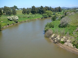
Whatawhata, previously also spelt Whata Whata, is a small town in the Waikato region on the east bank of the Waipā River, at the junction of State Highways 23 and 39, 12 km (7.5 mi) from Hamilton. Te Araroa tramping route passes through Whatawhata.

<span class="mw-page-title-main">Te Uku</span> Settlement in Waikato, New Zealand

Te Uku is a small, mainly farming, settlement on SH23 in the North Island of New Zealand, located 34 km (21 mi) from Hamilton and 11 km (6.8 mi) from Raglan. It has a 4-Square shop, church, coffee stall and art gallery, filling station, hall, school and Xtreme Zero Waste recycle bins.

Horotiu is a small township on the west bank of the Waikato River in the Waikato District of New Zealand. It is on the Waikato Plains 13 km (8.1 mi) north of Hamilton and 5 km (3.1 mi) south of Ngāruawāhia. From early in the 20th century it developed around a freezing works and other industries.

<span class="mw-page-title-main">Marokopa</span> Village in Waikato region, New Zealand

Marokopa is a rural community in Waitomo District and Waikato region of New Zealand. It is located close to the coast between Awakino and Kawhia Harbour. The meshblock includes the coastal township of Marokopa, at the mouth of the Marokopa River, and the south side of the small village of Awamarino, about 10 km (6.2 mi) upstream.

<span class="mw-page-title-main">Whitikahu</span> Locality in Waikato, New Zealand

Whitikahu is a settlement scattered along Whitikahu Rd in the Waikato District and Waikato region of New Zealand's North Island.

<span class="mw-page-title-main">Motumaoho</span> Village in Waikato, New Zealand

Motumaoho is a small village in the Waikato region of New Zealand's North Island, just to the west of the Pakaroa Range. It is on SH26, 25 km (16 mi) east of Hamilton and 7 km (4.3 mi) west of Morrinsville. The village is bordered by the Waitakaruru Stream to the east. Motumaoho can be translated as an intruding clump of trees.

References

  1. Hariss, Gavin. "Aria, Waikato". topomap.co.nz. NZ Topo Map.
  2. Moorby, Caitlin (6 September 2017). "Tourists rescued from flooded car as wild weather hits North Island". Stuff. Waikato Times.
  3. "Tornado, lightning and flooding cause mayhem around NZ". Stuff. 6 September 2017.
  4. "Crown Lands Ballot. TARANAKI DAILY NEWS". paperspast.natlib.govt.nz. 12 March 1904. Archived from the original on 4 January 2022. Retrieved 4 January 2022.
  5. "THE ARIA DISTRICT. KING COUNTRY CHRONICLE". paperspast.natlib.govt.nz. 21 February 1929. Archived from the original on 4 January 2022. Retrieved 4 January 2022.
  6. Steve Edbrooke. "Mineral Commodity Report 18 - Coal. Institute of Geological and Nuclear Sciences Ltd" (PDF). Archived (PDF) from the original on 7 April 2017.
  7. "Rorison Mineral Developments". Google Maps. Archived from the original on 4 January 2022. Retrieved 4 January 2022.
  8. "Rorisons RMD - A legacy of Lime from quarry to farm". rorisons.co.nz. Retrieved 4 January 2022.
  9. "ARIA POST OFFICE. KING COUNTRY CHRONICLE". paperspast.natlib.govt.nz. 27 April 1922. Archived from the original on 4 January 2022. Retrieved 4 January 2022.
  10. "THE ARIA DISTRICT. KING COUNTRY CHRONICLE". paperspast.natlib.govt.nz. 21 February 1929. Archived from the original on 4 January 2022. Retrieved 4 January 2022.
  11. Ron. "Aria Factory - c1911". ketenewplymouth.peoplesnetworknz.info. Retrieved 4 January 2022.
  12. "ArcGIS Web Application". statsnz.maps.arcgis.com. Retrieved 8 November 2022.
  13. "Population estimate tables - NZ.Stat". Statistics New Zealand . Retrieved 25 October 2022.
  14. 1 2 "Statistical area 1 dataset for 2018 Census". Statistics New Zealand. March 2020. Aria (187200). 2018 Census place summary: Aria
  15. "Meshblock Electoral Populations 2020 for proposed boundaries data". Statistics New Zealand. April 2020. Meshblocks 1014500, 1014600, 1014900 and 1015000.
  16. "Aria School Official School Website". aria.school.nz.
  17. "Aria School Ministry of Education School Profile". educationcounts.govt.nz. Ministry of Education.
  18. "New Zealand Schools Directory". New Zealand Ministry of Education. Retrieved 12 December 2022.
  19. "Aria School Education Review Office Report". ero.govt.nz. Education Review Office.
  20. "About Us". Aria School. Retrieved 15 November 2020.