   Tena Quito Puerto Francisco de Orellana | |
| UTC time | 2010-08-12 11:54 |
|---|---|
| ISC event | |
| USGS-ANSS | ComCat |
| Local date | 12 August 2010 |
| Local time | 06:54 |
| Magnitude | 7.1 Mw [1] |
| Depth | 206.7 km (128.4 mi) |
| Epicenter | 1°15′58″S77°18′22″W / 1.266°S 77.306°W [1] |
| Fault | Nazca-South American Plate [1] |
| Areas affected | Ecuador |
The 2010 Ecuador earthquake occurred on 12 August at 11:54:15 UTC with a moment magnitude of 7.1. The earthquake was centered approximately 63.9 km (39.7 mi) from the town of Tena, and 170 km (110 mi) from the capital Quito. Due to its depth of 206.7 km (128.4 mi), the earthquake was felt throughout Ecuador, as well as parts of Peru and Colombia.
The moment magnitude scale is a measure of n earthquake's magnitude based on its seismic moment, expressed in terms of the familiar magnitudes of the original "Richter" magnitude scale.

An earthquake is the shaking of the surface of the Earth, resulting from the sudden release of energy in the Earth's lithosphere that creates seismic waves. Earthquakes can range in size from those that are so weak that they cannot be felt to those violent enough to toss people around and destroy whole cities. The seismicity, or seismic activity, of an area is the frequency, type and size of earthquakes experienced over a period of time. The word tremor is also used for non-earthquake seismic rumbling.
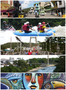
Tena, the capital of the Napo Province, is a city in the Amazon rainforest. Known as the “cinnamon capital" of Ecuador, and founded by missionary explorers, Tena has emerged as a major commercial center of Ecuador. It is home to a regional hospital and many tourist related businesses, including a small airport and a vital bus terminal.
Contents
Despite its large magnitude, the earthquake did not cause much damage because of its location in the sparsely populated Amazon rainforest and its extreme depth. One injury was reported, and homes were damaged in Guayaquil and Manta. [2] Because the epicenter was located so far inland, there was no threat of a tsunami. [2]

The Amazon rainforest, also known in English as Amazonia or the Amazon Jungle, is a moist broadleaf forest in the Amazon biome that covers most of the Amazon basin of South America. This basin encompasses 7,000,000 km2 (2,700,000 sq mi), of which 5,500,000 km2 (2,100,000 sq mi) are covered by the rainforest. This region includes territory belonging to nine nations. The majority of the forest is contained within Brazil, with 60% of the rainforest, followed by Peru with 13%, Colombia with 10%, and with minor amounts in Venezuela, Ecuador, Bolivia, Guyana, Suriname and French Guiana. States or departments in four nations contain "Amazonas" in their names. The Amazon represents over half of the planet's remaining rainforests, and comprises the largest and most biodiverse tract of tropical rainforest in the world, with an estimated 390 billion individual trees divided into 16,000 species.

Guayaquil, officially Santiago de Guayaquil, is the largest and most populous city in Ecuador. with 2,578,201 people in the metropolitan area, as well as the nation's main port. The city is the capital of Guayas Province and the seat of Guayaquil canton.

Manta is a mid-sized city in Manabí Province, Ecuador. It is the second most populous city in the province, the fifth most populous in the country. Manta has existed since Pre-Columbian times. It was a trading post for the Mantas. According to the 2001 census, the city had 192,322 inhabitants. Its main economic activity is tuna fishing. Other economic activities include tourism and a chemical industry with products from cleaning supplies to oils and margarine.
The earthquake was a result of subduction of the Nazca and South American Plates at the Peru–Chile Trench. Earthquakes are very common in the area near the Peru-Chile Trench. Six other earthquakes with magnitudes greater than 7 Mw had occurred in the past 40 years within 400 km (250 mi) of the location of the 2010 earthquake. [1]

Subduction is a geological process that takes place at convergent boundaries of tectonic plates where one plate moves under another and is forced to sink due to gravity into the mantle. Regions where this process occurs are known as subduction zones. Rates of subduction are typically in centimeters per year, with the average rate of convergence being approximately two to eight centimeters per year along most plate boundaries.
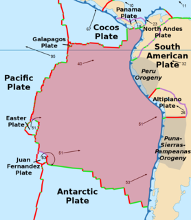
The Nazca Plate, named after the Nazca region of southern Peru, is an oceanic tectonic plate in the eastern Pacific Ocean basin off the west coast of South America. The ongoing subduction, along the Peru–Chile Trench, of the Nazca Plate under the South American Plate is largely responsible for the Andean orogeny. The Nazca Plate is bounded on the west by the Pacific Plate and to the south by the Antarctic Plate through the East Pacific Rise and the Chile Rise respectively. The movement of the Nazca Plate over several hotspots has created some volcanic islands as well as east-west running seamount chains that subduct under South America. Nazca is a relatively young plate both in terms of the age of its rocks and its existence as an independent plate having been formed from the break-up of the Farallon Plate about 23 million years ago. The oldest rocks of the plate are about 50 million years old.

The South American Plate is a major tectonic plate which includes the continent of South America as well as a sizable region of the Atlantic Ocean seabed extending eastward to the African Plate, with which it forms the southern part of the Mid-Atlantic Ridge.


