  | |
| UTC time | 2010-07-18 13:34:59 |
|---|---|
| ISC event | 14996648 |
| USGS-ANSS | ComCat |
| Local date | 18 July 2010 |
| Local time | |
| Magnitude | 7.3 Mw |
| Depth | 57.6 kilometres (35.8 mi) |
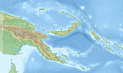
| Epicenter | 6°01′08″S150°29′49″E / 6.019°S 150.497°E Coordinates: 6°01′08″S150°29′49″E / 6.019°S 150.497°E |
| Areas affected | Papua New Guinea |
| Max. intensity | VII (Very strong) |
| Tsunami | No |
| Casualties | none [1] |
On July 18, 2010 a 7.3 magnitude earthquake [2] occurred in New Britain, Papua New Guinea. This quake was the second in a series of two earthquakes to hit New Britain on July 18, the first one measuring magnitude 6.9. [3] A tsunami warning was issued but later lifted. [4] Some houses in the area of the earthquake were reported collapsed. [5]

New Britain is the largest island in the Bismarck Archipelago of Papua New Guinea. It is separated from the island of New Guinea by the Dampier and Vitiaz Straits and from New Ireland by St. George's Channel. The main towns of New Britain are Rabaul/Kokopo and Kimbe. The island is roughly the size of Taiwan. While the island was part of German New Guinea, it was named Neupommern.
Papua New Guinea, officially the Independent State of Papua New Guinea, is an Oceanian country that occupies the eastern half of the island of New Guinea and its offshore islands in Melanesia, a region of the southwestern Pacific Ocean north of Australia. Its capital, located along its southeastern coast, is Port Moresby. The western half of New Guinea forms the Indonesian provinces of Papua and West Papua.
Another strong earthquake struck New Britain on August 4, 22:01:45 UTC (8:01:45 am local time), measuring magnitude 7.0 at a depth of 54 km (33.6 mi). The maximum Mercalli intensity of the August earthquake was also VII (Very strong). [6]
