Achray, Ontario

Last updated

Achray
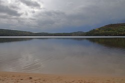
Grand Lake Algonquin.jpg
Grand Lake at Achray
Canada Ontario location map 2.svg
Red pog.svg
Achray
Location of Achray in Ontario
Coordinates: 45°52′04″N77°45′25″W / 45.86778°N 77.75694°W / 45.86778; -77.75694
Country Canada
Province Ontario
District Nipissing
Census area Unorg. South Nipissing
Elevation
228 m (748 ft)
Population
 (2016) [1]
  Total0
Time zone UTC-5 (Eastern Time Zone)
  Summer (DST) UTC-4 (Eastern Time Zone)
Postal Code FSA
K0J
Area codes 705, 249

Achray is an unincorporated place and former railway point in geographic Stratton Township in the Unorganized South Part of Nipissing District in northeastern Ontario, Canada. [2] It lies in northern Algonquin Provincial Park on the northern shore of Grand Lake, part of the Barron River system, and functions today as a campground site.

It was originally a station with a passing track on the main line of the Canadian Northern Railway, between Hydro to the west and Kathmore to the east, later taken over by Canadian National Railway as the CN Beachburg Subdivision and now abandoned in the park. Once a major centre for park administration, only a small complement of backcountry rangers still operates out of Achray. The old park operations centre is now a cinema/interpretive centre and the bunk house is now a tourist lodge at the canoe rental place on the Achray Road.

Tom Thomson's painting, The Jack Pine , was inspired by the scenery in this area. Thomson worked as a fire ranger at Achray in 1916. [3] The cabin in which Thomson is reputed to have lived in now has some exhibits on the park history and Tom Thomson.

The campground has 45 campsites without electricity. [4] Facilities are considered to be primitive compared to other campgrounds located in the park. The central park store is the former Deputy Chief Ranger Headquarters that was built in the 1930s by park rangers, Claude McFarland, an expert stonemason, and William Mooney, a skilled carpenter. It was built with stone quarried on the opposite shore of Grand Lake.

Achray has two hiking trails, including the small interpretive Berm Lake Trail, and the longer Eastern Pines Backpacking Trail that leads to a waterfall on the Barron River as it exits Stratton Lake. [4] [5]

The campground is a common starting point for multiday canoe trips on the Barren River to the Barron Canyon. [6]

See also

Related Research Articles

<span class="mw-page-title-main">Tom Thomson</span> Canadian painter (1877–1917)

Thomas John Thomson was a Canadian artist active in the early 20th century. During his short career, he produced roughly 400 oil sketches on small wood panels and approximately 50 larger works on canvas. His works consist almost entirely of landscapes, depicting trees, skies, lakes, and rivers. He used broad brush strokes and a liberal application of paint to capture the beauty and colour of the Ontario landscape. Thomson's accidental death by drowning at 39 shortly before the founding of the Group of Seven is seen as a tragedy for Canadian art.

<span class="mw-page-title-main">Algonquin Provincial Park</span> Provincial park in Ontario, Canada

Algonquin Provincial Park is an Ontario provincial park located between Georgian Bay and the Ottawa River, mostly within the Unorganized South Part of Nipissing District. Established in 1893, it is the oldest provincial park in Canada. Additions since its creation have increased the park to its current size of about 7,653 km2 (2,955 sq mi). The park is contiguous with several smaller, administratively separate provincial parks that protect important rivers in the area, resulting in a larger total protected area.

<span class="mw-page-title-main">Madawaska River (Ontario)</span> River in Ontario, Canada

The Madawaska River is a river in the Saint Lawrence River drainage basin in Ontario, Canada. The river is 230 km (143 mi) long and drains an area of 8,470 km2 (3,270 sq mi). Its name comes from an Algonquian band of the region known as "Matouweskarini", meaning "people of the shallows".

<span class="mw-page-title-main">Unorganized South Nipissing District</span> Unorganized area in Ontario, Canada

Unorganized South Nipissing District is an unorganized area in north-central Ontario, in the District of Nipissing. It is almost entirely within and includes most of Algonquin Provincial Park.

<span class="mw-page-title-main">Petawawa River</span> River in Ontario, Canada

The Petawawa River is a river in the Saint Lawrence River drainage basin in Nipissing District and Renfrew County in eastern and northeastern Ontario, Canada. The river flows from Algonquin Provincial Park to the Ottawa River at the town of Petawawa, and is only one of two major tributaries of the Ottawa River to flow completely freely. The river's name comes from the Algonquian for "where one hears a noise like this", which refers to its many rapids.

<span class="mw-page-title-main">Barron River (Ontario)</span> River in Ontario, Canada

The Barron River is a river in the Saint Lawrence River drainage basin in Nipissing District and Renfrew County, Ontario, Canada. It flows from Clemow Lake in northern Algonquin Provincial Park and joins the Petawawa River, whose southern branch it forms, in the municipality of Laurentian Hills, near the municipality of Petawawa.

<span class="mw-page-title-main">Kiosk, Ontario</span> Place in Ontario, Canada

Kiosk is an unincorporated place and former railway point and community in geographic Pentland Township in the Unorganized South Part of Nipissing District in northeastern Ontario, Canada. Kiosk is surrounded by but not within Algonquin Provincial Park, for which it provides a road access point via Ontario Highway 630, and is located on Kioshkokwi Lake on the Amable du Fond River on the right bank of the outlet of that river from the lake and across the river from the unincorporated place of Coristine. The name "Kiosk" is an abbreviated form of the lake's name, which means "lake of many gulls".

Kearney is a town and municipality in the Almaguin Highlands region of Parry Sound District of Ontario, Canada. With a landmass of 528 square kilometres and a year-round population of 974 in the Canada 2021 Census, Kearney claims to be the "Biggest Little Town in Ontario."

<span class="mw-page-title-main">Whiteshell Provincial Park</span> Provincial park in Manitoba, Canada

Whiteshell Provincial Park is a provincial park in southeast Manitoba, approximately 120 kilometres (75 mi) east of the city of Winnipeg. The park is considered to be a Class II protected area under the IUCN protected area management categories. It is 275,210 hectares in size.

Lake Traverse is the name of two adjacent unincorporated places, one a former railway point and the other a compact rural community, in geographic White Township in the Unorganized South Part of Nipissing District in northeastern Ontario, Canada. They are both located within Algonquin Provincial Park, the compact rural community on Lake Travers on the Petawawa River and the railway point slightly inland.

Odenback is an unincorporated place and former railway point in geographic Deacon Township in the Unorganized South Part of Nipissing District in northeastern Ontario, Canada. Odenback is located within Algonquin Provincial Park on Radiant Lake at the confluence of the tributary Little Madawaska River with the Petawawa River.

Radiant is an unincorporated place and former railway point in geographic Deacon Township in the Unorganized South Part of Nipissing District in northeastern Ontario, Canada. Radiant is located within Algonquin Provincial Park on Radiant Lake on the Petawawa River.

<span class="mw-page-title-main">Grand Lake (Nipissing District)</span> Lake in the Ottawa River drainage basin

Grand Lake is a lake in the Ottawa River drainage basin in the geographic townships of Barron and Stratton in the Unorganized South Part of Nipissing District in Northeastern Ontario, Canada.

Hydro is an unincorporated place and former railway point in geographic Barron Township in the Unorganized South Part of Nipissing District in northeastern Ontario, Canada. Hydro is located within Algonquin Provincial Park on Grand Lake on the Barron River.

Government Park is an unincorporated place and former railway point in geographic Boyd Township in the Unorganized South Part of Nipissing District in northeastern Ontario, Canada. Government Park is located within Algonquin Provincial Park on Cedar Lake on the Petawawa River.

Mink Lake is an unincorporated place and former railway point in geographic Pentland Township in the Unorganized South Part of Nipissing District in northeastern Ontario, Canada. Mink Lake is located within Algonquin Provincial Park at the eastern end of Mink Lake in the Amable du Fond River drainage basin.

<span class="mw-page-title-main">Ascalon, Ontario</span> Place in Ontario, Canada

Ascalon is an unincorporated place and former railway point in geographic Pentland Township in the Unorganized South Part of Nipissing District in northeastern Ontario, Canada. Ascalon is located within Algonquin Provincial Park at the northwestern end of Mink Lake in the Amable du Fond River drainage basin.

Coristine is an unincorporated place and former railway point in geographic Pentland Township in the Unorganized South Part of Nipissing District in northeastern Ontario, Canada. Coristine is located within Algonquin Provincial Park on Kioshkokwi Lake on the Amable du Fond River, on the right bank of the outlet of that river from the lake and opposite the settlement of Kiosk.

<span class="mw-page-title-main">Death and legacy of Tom Thomson</span> The death and legacy of Canadian artist Tom Thomson

The Canadian painter Tom Thomson died on 8 July 1917, on Canoe Lake in Algonquin Provincial Park in Nipissing District, Ontario, Canada. After Thomson drowned in the water, his upturned canoe was discovered later that afternoon and his body eight days later. Many theories regarding Thomson's death—including that he was murdered or committed suicide—have become popular in the years since his death, though these ideas lack any substantiation.

<span class="mw-page-title-main">Rock Lake (Algonquin Park)</span> Lake in Algonquin Park, Ontario, Canada

Rock Lake is a lake located in Algonquin Provincial Park in Haliburton County, Ontario, Canada.

References

  1. 2016 Canadian census population of Census Block 35480228217
  2. "Achray". Geographical Names Data Base . Natural Resources Canada . Retrieved 22 February 2011.
  3. Murray, Joan (1999). Tom Thomson: Trees (1st Canadian ed.). Toronto: McArthur & Co. ISBN   1552780929.
  4. 1 2 "Achray Campground". The Friends of Algonquin Park. Retrieved 10 August 2011.
  5. "Algonquin – Achray". ontarioparks.com. Ontario Parks. Retrieved 11 October 2022.
  6. Hap Wilson (1993). Rivers of the Upper Ottawa Valley – Myth, Magic & Adventure. Canadian Recreational Canoeing Association. ISBN   1-8954-6505-2.

Other map sources: