Related Research Articles
Bellefonte is a town in New Castle County, Delaware, United States. According to the 2010 Census, the population of the town is 1,193.
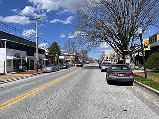
California is a neighborhood in urban Louisville, Kentucky, United States. It is bounded on the north by Broadway, on the east by Ninth Street, on the south by Oak Street, and on the west by Twenty-Sixth Street. There are no written records of the beginning of the neighborhood, but the area was settled by German immigrants around 1849. It is said that the subdivision, initially called Henderson, came to be known as California because it was the "far west" of Louisville.

Ioannes Paulus II Peninsula is an ice-covered peninsula on the north coast of Livingston Island in the South Shetland Islands, Antarctica that is bounded by Hero Bay to the east and Barclay Bay to the west. It extends 13 km in length in south–north direction and is 8 km wide. Its north extremity is formed by the ice-free Cape Shirreff, an area visited by early 19th century sealers. The peninsula's interior is occupied by Oryahovo Heights.

Great Cranberry Island is an island located in Maine, United States. It is the largest of the five islands of the Town of Cranberry Isles. It is roughly two miles long and one mile wide.
Merrimac was an unincorporated community in Butte County, California located along Oroville-Quincy Road about 2.1 miles (3.4 km) south of the Plumas County line at an elevation of 3999 feet. Nearby is Rogers Cow Camp, a campground in Lassen National Forest.

The Five Mile River is a 10.1-mile-long (16.3 km) river in central Massachusetts, part of the Chicopee River watershed. It rises north of Dean Pond in the Town of Oakham within Rutland State Forest and flows south through Dean Pond to Brooks Pond, 2.5 miles (4.0 km) northeast of North Brookfield, then continues south to its mouth at the north end of Lake Lashaway, also in North Brookfield.

San Francisco Plaza was the name of three towns in Catron County, New Mexico, United States. Located in the San Francisco River Valley, the towns were settled by Spanish settlers in the 1860s. Today Middle San Francisco Plaza is called Middle Frisco, Lower San Francisco is called Lower Frisco, and Upper San Francisco was renamed Reserve when U.S. Forest Service headquarters were built there.

Shinhidaka is a town located in Hidaka Subprefecture, Hokkaido, Japan. Shinhidaka is the most populous town, and the economic center of Hidaka Subprefecture.

Lava is a district of the City Municipality of Celje and a locality in the northwestern part of the city of Celje. Until 1982, Lava was an independent settlement.
Mullen is a former settlement in Yolo County, California. It was located on the Southern Pacific Railroad 2 miles (3.2 km) south-southeast of Woodland, at an elevation of 69 feet. A 1913 book described Mullen, along with Merritt, as farming towns along the main automobile route from Davis to Woodland. It still appeared on maps as of 1915.
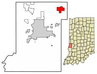
Fontanet is an unincorporated census-designated place in central Nevins Township, Vigo County, in the U.S. state of Indiana. It lies along Baldwin St., northeast of the city of Terre Haute, the county seat of Vigo County. Its elevation is 614 feet (187 m), and it is located at 39°34′34″N87°14′37″W. Although Fontanet is unincorporated, it has a post office, with the ZIP Code of 47851.

The North Isle of Gletness is one of the Shetland Islands. It is east of the Shetland Mainland, near Gletness in Nesting parish, and is so called in contradistinction to the South Isle of Gletness. It is 33m at its highest point.
Hüseynuşağı is a village in the Qubadli Rayon of Azerbaijan.

Llandysilio is a small village and community in Montgomeryshire, Powys, Wales.
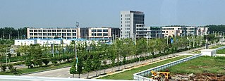
Guzhen County is a county in the north of Anhui Province, China. It is under the administration of Bengbu city.
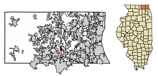
Port Barrington is a village in Lake and McHenry counties in the U.S. state of Illinois. It was formerly known as Fox River Valley Gardens, but the name was changed in 2002 to Port Barrington. Per the 2020 census, the population was 1,584.

Pasadur is a small coastal village in southern Croatia. It is located on the northwestern shore of the island of Lastovo and the eastern shore of the nearby isle of Prežba, the islands being connected by a small bridge. Administratively it belongs to the Lastovo municipality, which is in turn part of the Dubrovnik-Neretva County.
Ostrovo is a village in the municipality of Veliko Gradište, Serbia. It is a peninsula, formerly a river island. According to the 2002 census, the village has a population of 300 people.
Vareslaid is an island belonging to the country of Estonia.
Karuma is a settlement in the Western Region of Uganda.
References
- ↑ "Achugao MP - information about the village and its administration". Cities and Towns in the United States. Retrieved 2023-07-09.
15°14′37″N145°45′58″E / 15.24361°N 145.76611°E
| | This Northern Marianas location article is a stub. You can help Wikipedia by expanding it. |