Adamsville, Pennsylvania | |
---|---|
Coordinates: 41°30′38″N80°22′11″W / 41.51056°N 80.36972°W Coordinates: 41°30′38″N80°22′11″W / 41.51056°N 80.36972°W | |
Country | United States |
State | Pennsylvania |
County | Crawford |
Township | West Fallowfield |
Area | |
• Total | 0.39 sq mi (1.02 km2) |
• Land | 0.39 sq mi (1.02 km2) |
• Water | 0.00 sq mi (0.00 km2) |
Elevation | 1,040 ft (320 m) |
Population | |
• Total | 88 |
• Density | 223.35/sq mi (86.32/km2) |
Time zone | UTC-4 (EST) |
• Summer (DST) | UTC-5 (EDT) |
ZIP code | 16110 |
Area code | 814 |
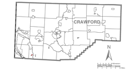
Adamsville is a census-designated place (CDP) in Crawford County, Pennsylvania, United States. The population was 67 at the 2010 census, [3] down from 117 in 2000.
Adamsville is located in southwestern Crawford County at 41°30′38″N80°22′11″W / 41.51056°N 80.36972°W (41.510643, -80.369802), [4] in southern West Fallowfield Township. Pennsylvania Route 18 passes through the community, leading north 3 miles (5 km) to Hartstown and south 8 miles (13 km) to Greenville.
According to the United States Census Bureau, the CDP has a total area of 0.18 square miles (0.46 km2), all land. [3]
Historical population | |||
---|---|---|---|
Census | Pop. | %± | |
2020 | 88 | — | |
U.S. Decennial Census [5] [2] |
As of the census [6] of 2000, there were 117 people, 49 households, and 39 families residing in the CDP. The population density was 698.4 people per square mile (265.7/km2). There were 54 housing units at an average density of 322.4/sq mi (122.6/km2). The racial makeup of the CDP was 100.00% White.
There were 49 households, out of which 28.6% had children under the age of 18 living with them, 65.3% were married couples living together, 8.2% had a female householder with no husband present, and 20.4% were non-families. 20.4% of all households were made up of individuals, and 14.3% had someone living alone who was 65 years of age or older. The average household size was 2.39 and the average family size was 2.72.
In the CDP the population was spread out, with 19.7% under the age of 18, 7.7% from 18 to 24, 28.2% from 25 to 44, 22.2% from 45 to 64, and 22.2% who were 65 years of age or older. The median age was 42 years. For every 100 females there were 105.3 males. For every 100 females age 18 and over, there were 91.8 males.
The median income for a household in the CDP was $29,821, and the median income for a family was $34,167. Males had a median income of $32,500 versus $16,250 for females. The per capita income for the CDP was $17,351. None of the population and none of the families were below the poverty line.
Big River is a census-designated place (CDP) in San Bernardino County, California, United States. The population was 1,327 at the 2010 census, up from 1,266 at the 2000 census.
Southgate is a census-designated place (CDP) in Sarasota County, Florida, United States. The population was 7,173 at the 2010 census. It is part of the Bradenton–Sarasota–Venice Metropolitan Statistical Area.
Masury is a census-designated place (CDP) in Trumbull County, Ohio, United States. The population was 2,618 at the 2000 census. It is part of the Youngstown–Warren–Boardman, OH-PA Metropolitan Statistical Area.
Carnot-Moon is a census-designated place (CDP) in central Moon Township, Allegheny County, Pennsylvania, United States. The population was 11,372 at the 2010 census.
Pine Glen is an unincorporated community and census-designated place (CDP) in Centre County, Pennsylvania, United States. It is part of the State College, Pennsylvania Metropolitan Statistical Area. It is part of Burnside Township. The population was 190 at the 2010 census.
Hyde is an unincorporated community and census-designated place (CDP) in Clearfield County, Pennsylvania, United States. The population was 1,303 at the 2020 census.
Atlantic is a census-designated place (CDP) in Crawford County, Pennsylvania, United States. The population was 77 at the 2010 census, up from 43 in 2000.
Conneaut Lakeshore is a census-designated place (CDP) in Crawford County, Pennsylvania, United States. The population was 2,395 at the 2010 census.
Fredericksburg is a census-designated place (CDP) in Crawford County, Pennsylvania, United States. The population was 733 at the 2010 census, down from 1,140 in 2000, when the CDP included the area that is now listed as Kerrtown.
Geneva is a census-designated place in Crawford County, Pennsylvania, United States. The population was 109 at the 2010 census.
Harmonsburg is a census-designated place (CDP) in Crawford County, Pennsylvania, United States. The population was 401 at the 2010 census, up from 356 in 2000.
Hartstown is a census-designated place (CDP) in Crawford County, Pennsylvania, United States. The population was 201 at the 2010 census, down from 246 in 2000.
Pymatuning Central is a census-designated place (CDP) in Crawford County, Pennsylvania, United States. The population was 2,269 at the 2010 census.
Pymatuning North is a census-designated place (CDP) in Crawford County, Pennsylvania, United States. The population was 311 at the 2010 census.
Pymatuning South is a census-designated place (CDP) in Crawford County, Pennsylvania, United States. The population was 479 at the 2010 census.
West Fallowfield Township is a township in Crawford County, Pennsylvania, United States. The population was 578 at the 2020 census, down from 605 at the 2010 census.
Lawnton is an unincorporated area and census-designated place (CDP) in Swatara Township, Dauphin County, Pennsylvania, United States. The population was 3,813 at the 2010 census. It is part of the Harrisburg–Carlisle Metropolitan Statistical Area.
New Castle Northwest is an unincorporated area and census-designated place (CDP) in Lawrence County, Pennsylvania, United States. The population was 1,413 at the 2010 census.
Oakwood is an unincorporated area and census-designated place (CDP) in Lawrence County, Pennsylvania, United States. The population was 2,270 at the 2010 census.
Gastonville is a census-designated place (CDP) in Washington County, Pennsylvania, United States. The population was 2,818 at the 2010 census.