
Denmark is a Nordic country located in Northern Europe. It consists of the Jutland Peninsula and several islands in the Baltic Sea, referred to as the Danish Archipelago. Denmark is located southwest of Sweden and due south of Norway and is bordered by the German state Schleswig-Holstein to the south, on Denmark's only land border, 68 kilometres long.

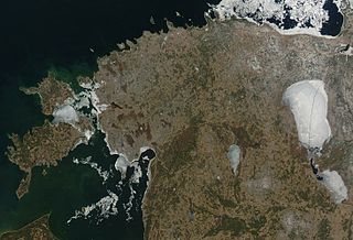
Djibouti is a country in the Horn of Africa. It is bordered by Eritrea in the north, Ethiopia in the west and south, and Somalia in the southeast. To the east is its coastline on the Red Sea and the Gulf of Aden. Rainfall is sparse, and most of the territory has a semi-arid to arid environment. Lake Assal is a saline lake which lies 155 m (509 ft) below sea level, making it the lowest point on land in Africa and the third-lowest point on Earth after the Sea of Galilee and the Dead Sea. Djibouti has the fifth smallest population in Africa. Djibouti's major settlements include the capital Djibouti City, the port towns of Tadjoura and Obock, and the southern cities of Ali Sabieh and Dikhil. It is the forty-six country by area in Africa and 147st largest country in the world by land area, covering a total of 23,200 km2 (9,000 sq mi), of which 23,180 km2 (8,950 sq mi) is land and 20 km2 (7.7 sq mi) is water.
Between 57.3 and 59.5 latitude and 21.5 and 28.1 longitude, Estonia lies on the eastern shores of the Baltic Sea on the level northwestern part of the rising East European Platform. It borders the Gulf of Finland, between Latvia and Russia. Average elevation reaches 50 m (164 ft).

The Republic of Haiti comprises the western three-eighths of the island of Hispaniola, west of the Dominican Republic. Haiti is positioned east of the neighboring island of Cuba, between the Caribbean Sea and the North Atlantic Ocean. Haiti's geographic coordinates are at a longitude of 72° 25′ west and a latitude of 19° 00′ north.

Morocco is the northwesternmost country which spans from the Mediterranean Sea and Atlantic Ocean on the north and the west respectively, into large mountainous areas in the interior, to the Sahara desert in the far south. Morocco is a Northern African country, located in the extreme northwest of Africa on the edge of continental Europe. The Strait of Gibraltar separates Spain from Morocco with a 13 kilometres (8.1 mi) span of water. Morocco borders the North Atlantic Ocean to the west, and the western Mediterranean Sea to the north, and has borders with Algeria and disputed Western Sahara.

Panama is a country located in Central America, bordering both the Caribbean Sea and the Pacific Ocean, between Colombia and Costa Rica. Panama is located on the narrow and low Isthmus of Panama.
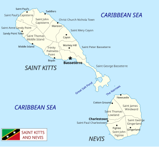
Saint Kitts and Nevis is a twin island country with a total landmass of just 270 square kilometres (104 sq mi). The island of St. Kitts, the larger of the two, is 180 square kilometres (68 sq mi) in size and is located at latitude 17.30 N, and longitude 62.80 W. Nevis is 93 square kilometres (36 sq mi) and located at latitude 17.10 N, longitude 62.35 W, approximately 3 km south-east of St. Kitts. The islands are about one-third of the way from Puerto Rico to Trinidad and Tobago. The islands are volcanic and mountainous.

Sierra Leone is a country in West Africa with a North Atlantic Ocean coastline to the west. It lies on the African Plate. The island's main geographical features include wooded hill country, an upland plateau, and mountains in the east. The highest peak is Mount Bintumani, which is 1,948 meters (6,391 ft) above sea level. The coastline has a belt of mangrove swamps. Freetown, the nation's capital city, has one of the world's largest natural harbours. The Rokel River is the largest river in Sierra Leone. It is 400 kilometres (250 mi) long and has a basin with a total area of 10,622 square kilometres (4,101 sq mi).
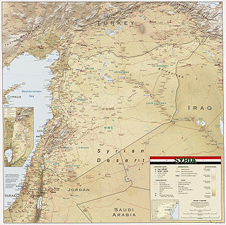
Syria is located in Western Asia, north of the Arabian Peninsula, at the eastern end of the Mediterranean Sea. It is bordered by Turkey to the north, Lebanon and Palestine to the west and southwest, Iraq to the east, and Jordan to the south. It consists of mountain ranges in the west and a steep area inland. In the east is the Syrian Desert and in the south is the Jabal al-Druze Range. The former is bisected by the Euphrates valley. A dam built in 1973 on the Euphrates created a reservoir named Lake Assad, the largest lake in Syria. The highest point in Syria is Mount Hermon on the Lebanese border at 2,814 metres or 9,232 feet. Between the humid Mediterranean coast and the arid desert regions lies a semiarid steep zone extending across three-quarters of the country, which receives hot, dry winds blowing across the desert. Syria is extensively depleted, with 28 percent of the land arable, 4 percent dedicated to permanent crops, 46 percent utilized as meadows and pastures, and only 3 percent forest and woodland.

Vietnam is located on the eastern margin of the Indochinese peninsula and occupies about 331,211.6 square kilometers, of which about 25% was under cultivation in 1987. It borders the Gulf of Tonkin, Gulf of Thailand, and Pacific Ocean, along with China, Laos, and Cambodia. The elongated roughly S shaped country has a north-to-south distance of 1,650 km (1,030 mi) and is about 50 km (31 mi) wide at the narrowest point. With a coastline of 3,260 km (2,030 mi), excluding islands, Vietnam claims 12 nautical miles as the limit of its territorial waters, an additional 12 nautical miles as a contiguous customs and security zone. It has an exclusive economic zone of 417,663 km2 (161,261 sq mi) with 200 nautical miles.

Yemen is located in Southwest Asia, at the southern tip of the Arabian Peninsula, between Oman and Saudi Arabia. It is situated at the entrance to the Bab-el-Mandeb Strait, which links the Red Sea to the Indian Ocean and is one of the most active and strategic shipping lanes in the world. Yemen has an area of 527,970 square kilometres (203,850 sq mi), including the islands of Perim at the southern end of the Red Sea and Socotra at the entrance to the Gulf of Aden. Yemen's land boundaries total 1,746 kilometres (1,085 mi). Yemen borders Saudi Arabia to the north and Oman to the northeast. Through the Socotra island, Yemen also shares borders with the Guardafui Channel and the Somali Sea.

Fiji is a group of volcanic islands in the South Pacific, lying about 4,450 kilometres (2,765 mi) southwest of Honolulu and 1,770 km (1,100 mi) north of New Zealand. Of the 332 islands and 522 smaller islets making up the archipelago, about 106 are permanently inhabited. The total land size is 18,272 km2 (7,055 sq mi). It has the 26th largest Exclusive Economic Zone of 1,282,978 km2 (495,361 sq mi).

Anguilla is an island in the Leeward Islands. It has numerous bays, including Barnes, Little, Rendezvous, Shoal, and Road Bays.

Bangladesh is a densely populated, low-lying, mainly riverine country located in South Asia with a coastline of 580 km (360 mi) on the northern littoral of the Bay of Bengal. The delta plain of the Ganges (Padma), Brahmaputra (Jamuna), and Meghna Rivers and their tributaries occupy 79 percent of the country. Four uplifted blocks occupy 9 percent and steep hill ranges up to approximately 1,000 metres (3,300 ft) high occupy 12 percent in the southeast and in the northeast. Straddling the Tropic of Cancer, Bangladesh has a tropical monsoon climate characterised by heavy seasonal rainfall, high temperatures, and high humidity. Natural disasters such as floods and cyclones accompanied by storm surges periodically affect the country. Most of the country is intensively farmed, with rice the main crop, grown in three seasons. Rapid urbanisation is taking place with associated industrial and commercial development. Exports of garments and shrimp plus remittances from Bangladeshis working abroad provide the country's three main sources of foreign exchange income.
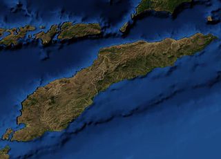
The geography of East Timor exhibits a mountainous terrain on the eastern half of the island of Timor in Southeast Asia. East Timor includes the eastern half of Timor, the Ocussi-Ambeno region on the northwest portion of the island of Timor, and the islands of Atauro and Jaco. The country is located northwest of Australia in the Lesser Sunda Islands at the eastern end of the Indonesian Archipelago. 'Timor' is a Portuguese derivation of 'Timor', the Malay word for "Orient"; the island of Timor is part of the Malay Archipelago and is the largest and easternmost of the Lesser Sunda Islands. East Timor is the only Asian nation to lie entirely within the Southern Hemisphere. The Loes River is the longest with a length of 80 km (50 mi). This river system covers an area of 2,184 km2 (843 sq mi). It is a small country with a land size of 14,919 km2 (5,760 sq mi). The exclusive economic zone is 70,326 km2 (27,153 sq mi).

The Obock Region is a region in northern Djibouti. It has a land area of 4,700 square kilometres, and had a population of 37,856 in 2009. It lies along the Red Sea, Bab-el-Mandeb, Gulf of Aden, Gulf of Tadjoura and includes the Seven Brothers, Doumeira Islands and the coastal city of Obock. It lies along a portion of the national border with Eritrea. In total area, it is larger than Cape Verde and smaller than Trinidad and Tobago. The topography of the region has highland and coastal plains.

Although agriculture is the second-largest sector in the economy, Libya depends on imports in most foods. Climatic conditions and poor soils limit farm output, and domestic food production meets about 25% of demand. Domestic conditions limit output, while income and population growth have increased food consumption. Because of low rainfall, agricultural projects like the Kufra Oasis rely on underground water sources. Libya's primary agricultural water source remains the Great Man-made River (GMMR), but significant resources are being invested in desalinization research to meet growing demand. Libyan agricultural projects and policies are overseen by a General Inspector; there is no Ministry of Agriculture, per se.

Agriculture is considered the backbone of Pakistan's economy, which relies heavily on its major crops. Pakistan's principal natural resources are arable land and water. Agriculture accounts for about 18.9% of Pakistan's GDP and employs about 42.3% of the labour force. The most agricultural province is Punjab where wheat & cotton are the most grown. Mango orchards are mostly found in Sindh and Punjab provinces,making it the world's 4th largest producer of mangoes.
Agriculture in Oman has been important for centuries. The government's economic development policy emphasizes the expansion of such non-oil sectors as agriculture, fishing, industry, and mining in its bid to diversify the economy and diminish its dependence on oil exports. The goal is to establish a sustainable economic base in preparation for the time when hydrocarbon reserves are depleted. The government launched several economic campaigns, naming 1988 and 1989 as Years of Agriculture and 1991 and 1992 as Years of Industry. Through these campaigns, the government has encouraged private-sector investment by allocating generous amounts of cash support for private industry to be disbursed mainly through official development banks. For example, the Oman Bank for Agriculture and Fisheries, created in 1981, extends loans at concessionary rates to individuals for whom farming or fishing is the principal activity. The bank acts as a distributive institution, receiving an interest subsidy from the government. In 1990 there were 1,308 loans, totaling RO4.7 million. Development programs also incorporate the government's policy of indigenization, with a large component of funds.

Moldova is an agrarian-industrial state, with agricultural land occupying 2,499,000 hectares in a total area of 3,384,600 hectares. It is estimated that 1,810,500 of these hectares are arable. Moldova is located in Eastern Europe, and is landlocked, bordering Romania and Ukraine. Moldova's agricultural sector benefits from a geographical proximity to large markets, namely the European Union. As a share of GDP, agriculture has declined from 56% in 1995 to 13.8% in 2013. Data from 2015 estimated that agriculture accounted for 12% of Moldova's GDP. Agriculture as a sector is export-oriented, with the composition of Moldova's total exports containing agriculture and the agri-food sector as a main component. 70% of agri-food exports in 2012 included beverages, edible fruits and nuts, oilseeds, vegetable preparations and cereals. Here, fruits, vegetables and nuts were attributed to 33% of Moldova's exports for 2011–2013. Moldova is also one of the top ten apple exporters in the world. However, because of the long-term emphasis on fruit, vegetables are often imported.


