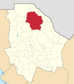
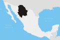
Ahumada Municipality

Last updated
Ahumada
Escudo Ahumada.png
Mexico Chihuahua Ahumada location map.svg
Municipality of Ahumada in Chihuahua
Coordinates: 30°37′N106°31′W / 30.617°N 106.517°W / 30.617; -106.517
CountryFlag of Mexico.svg  Mexico
StateFlag of Chihuahua.svg  Chihuahua
Founded1894
Named for Miguel Ahumada
Seat Villa Ahumada
Largest cityVilla Ahumada
Area
  Total17,131.5 km2 (6,614.5 sq mi)
Population
 (2010)
  Total11,457

Ahumada is one of the 67 municipalities of Chihuahua, in northern Mexico. The municipal seat lies at Villa Ahumada. The municipality covers an area of 17,131.5 km2.

Contents

As of 2010, the municipality had a total population of 11,457, [1] down from 11,727 as of 2005. [2]

The municipality had 553 localities, the largest of which (with 2010 populations in parentheses) was: Villa Ahumada (8,575), classified as urban. [1]

Geography

Towns and villages

NamePopulation (2005)
Villa Ahumada8,753
Moctezuma129
Ojo Caliente509
Álamos de Peña326
Carrizal102
Total Municipality11,727

Villa Ahumada

Villa Ahumada (officially Miguel Ahumada) is a town and seat of the municipality of Ahumada in the state of Chihuahua in northern Mexico. It is located along Highway 45, about 130 km south of Ciudad Juárez and 247 km north of the city of Chihuahua. As of 2010, the town had a population of 8,575. [1]

The city has several roadside restaurants and burrito stands and is known for its good cheese.

Villa Ahumada entered the international news in 2008 when it was terrorized for several hours by an out of town gang. This was presumably part of the wave of drug-smuggling related violence in Mexico that resulted in about 4,000 deaths between early 2007 and mid-2008. At the night of May 19, 2008, dozens of men drove through town, firing assault rifles and killing the police chief, two police officers and three civilians, and abducting at least 10 people. The remaining policemen then left, and the state and federal governments sent troops to restore order. Officials did not offer a theory about the perpetrators. According to local rumors, the town's drug dealers had been aligned with police and were linked to the Juárez Cartel. After a local drug boss was killed and another arrested, a rival gang was possibly trying to take over the drug trade along the route from Ciudad Juárez to the state of Sinaloa. [3] A similar attack occurred on February 10, 2009, in which 9 people were apparently kidnapped and driven to a ranch near El Vergel. The Mexican military pursued the assailants and 21 people were killed in the shootout. [4]

A number of small mining districts are located in the hills around Villa Ahumada, and the area is noted for its crystal specimens of wulfenite and other minerals. [5]

Carrizal

Carrizal is a rural community located in Ahumada Municipality, Chihuahua, Mexico. It had a population of 102 inhabitants at the 2010 census, [6] and is situated at an elevation of 1,120 meters above sea level.

Carrizal was founded November 26, 1772 as a Jesuit mission named San Fernando de las Amarillas del Carrizal. [7] It was also the location of a presidio and civilian settlement, tasked to guard the route of the Camino Real de Tierra Adentro.

Related Research Articles

<span class="mw-page-title-main">Ciudad Juárez</span> City in Chihuahua, Mexico

Ciudad Juárez, commonly referred to as just Juárez, is the most populous city in the Mexican state of Chihuahua. It was known until 1888 as El Paso del Norte. It is the seat of the Juárez Municipality with an estimated population of 2.5 million people. Juárez lies on the Rio Grande river, south of El Paso, Texas, United States. Together with the surrounding areas, the cities form El Paso–Juárez, the second largest binational metropolitan area on the Mexico–U.S. border, with a combined population of over 3.4 million people.

<span class="mw-page-title-main">Camargo, Chihuahua</span> City in the Mexican state of Chihuahua

Santa Rosalía de Camargo, originally called Santa Rosalía, and now known as "Ciudad Camargo", is a city in the eastern part of the Mexican state of Chihuahua, located at the confluence of the Rio Parral and the Rio Conchos in the Allende Valley. It serves as the municipal seat of Camargo municipality and also serves as an important agricultural and livestock center for the area. Ciudad Camargo was originally founded in 1740 and refounded in 1792.

The Juárez Cartel, also known as the Vicente Carrillo Fuentes Organization, is a Mexican drug cartel based in Ciudad Juárez, Chihuahua, across the Mexico—U.S. border from El Paso, Texas. The cartel is one of several drug trafficking organizations that have been known to decapitate their rivals, mutilate their corpses and dump them in public places to instill fear not only in the general public but also in local law enforcement and their rivals, the Sinaloa Cartel. Its current known leader is Juan Pablo Ledezma. The Juárez Cartel has an armed wing known as La Línea, a Juárez street gang that usually performs the executions and is now the cartel’s most powerful and leading faction. It also uses the Barrio Azteca gang to attack its enemies.

<span class="mw-page-title-main">Buenaventura Municipality</span> Municipality in the Mexican state of Chihuahua

Buenaventura is one of the 67 municipalities of Chihuahua, in northern Mexico. The municipal seat lies at San Buenaventura. The municipality covers an area of 8,938.3 km².

<span class="mw-page-title-main">La Concordia, Chiapas</span> Municipality in Chiapas, Mexico

La Concordia is a town and municipality in the Mexican state of Chiapas in southern Mexico.

<span class="mw-page-title-main">Juárez, Chiapas</span> Municipality in Chiapas, Mexico

Juárez is a town and municipality in the Mexican state of Chiapas in southern Mexico.

<span class="mw-page-title-main">Casas Grandes Municipality</span> Municipality in the Mexican state of Chihuahua

Casas Grandes Municipality is located in the northern Mexican state of Chihuahua. The municipal seat is the town of Casas Grandes, Chihuahua.

<span class="mw-page-title-main">La Trinitaria, Chiapas</span> Municipality in Chiapas, Mexico

La Trinitaria is a town and municipality in the Mexican state of Chiapas in southern Mexico.

<span class="mw-page-title-main">Unión Juárez, Chiapas</span> Municipality in Chiapas, Mexico

Unión Juárez is a town and municipality in the Mexican state of Chiapas in southern Mexico. The majority of the population in the municipality is Mam people that preserves the Mam traditions and Mam language.

<span class="mw-page-title-main">Camargo Municipality, Chihuahua</span> Municipality in the Mexican state of Chihuahua

Camargo is one of the 67 municipalities of Chihuahua, in northern Mexico. The municipal seat lies at Santa Rosalía de Camargo. The municipality covers an area of 16,066 km2.

<span class="mw-page-title-main">Matamoros Municipality, Chihuahua</span> Municipality in the Mexican state of Chihuahua

Matamoros is one of the 67 municipalities of Chihuahua, in northern Mexico. The municipal seat lies at Mariano Matamoros. The municipality covers an area of 1,139.5 km².

<span class="mw-page-title-main">Práxedis G. Guerrero Municipality</span> Municipality in the Mexican state of Chihuahua

Práxedis G. Guerrero is one of the 67 municipalities of Chihuahua, in northern Mexico. The municipal seat lies at Práxedis G. Guerrero, Chihuahua. The municipality covers an area of 808.97 km2 and stands on the US border close to Ciudad Juárez.

<span class="mw-page-title-main">Juárez Municipality, Chihuahua</span> Municipality in the Mexican state of Chihuahua

Juárez is one of the 67 municipalities of Chihuahua, in northern Mexico. The municipal seat lies at Ciudad Juárez. The municipality covers an area of 4,853 km2 (1,874 sq mi).

<span class="mw-page-title-main">Namiquipa Municipality</span> Municipality in the Mexican state of Chihuahua

Namiquipa is one of the 67 municipalities of Chihuahua, in northern Mexico. The municipal seat lies at Namiquipa.

<span class="mw-page-title-main">Lerdo Municipality</span> Municipality in the Mexican state of Durango

Lerdo is a municipality in the Mexican state of Durango. The municipal seat lies at Ciudad Lerdo. The municipality covers an area of 1868.8 km2.

Coordinated Operation Chihuahua or formerly known as Joint Operation Chihuahua is a Military and Federal Police operation started in 2008 by the Mexican Army and Policía Federal Preventiva. The objective is to "besiege" Ciudad Juárez to concentrate forces and saturate the area to confront the three cartels already operating in the city. Ciudad Juárez is known to be one of the most dangerous cities in the Americas. In the year 2007 more than 100 police officers were killed in Juárez in attacks blamed on organized crime. As a result of drug cartel violence, President Felipe Calderón has previously launched other Joint Operations in other states.

<span class="mw-page-title-main">Badiraguato Municipality</span> Municipality in the Mexican state of Sinaloa

Municipality of Badiraguato is a municipality in the Mexican state of Sinaloa in northwestern Mexico. The seat of the municipality is in the small town of Badiraguato.

La Línea is currently the leading faction of the Juárez Cartel originally designed to be one of the cartel's enforcer units set up by a number of former and active-duty policemen, heavily armed and extensively trained in urban warfare. Their corrupt "line" of policemen were set up to protect drug traffickers, but after forming an alliance with Barrio Azteca to fight off the forces of the Sinaloa Cartel in 2008, they established a foothold in Ciudad Juárez as the enforcement wing of the Juárez cartel. La Línea has also been involved in extortions and kidnappings. As of 2021, La Línea has formed an alliance with the Jalisco New Generation Cartel in Ciudad Juárez to fight off influence and incursions from the Sinaloa Cartel.

Barrio Azteca, or Los Aztecas, is a Mexican-American street and prison gang originally based in El Paso, Texas, USA and Ciudad Juarez, Chihuahua, Mexico. The gang was formed in the Coffield Unit, located near Tennessee Colony, Texas by Jose "Raulio" Rivera, a prisoner from El Paso, in the early 1980s. It expanded into a transnational criminal organization that traded mainly across the US-Mexico border. Currently one of the most violent gangs in the United States, they are said to have over 3,000 members across the country in locations such as New Mexico, Texas, Massachusetts, and Pennsylvania as well as at least 5,000 members in Ciudad Juarez, Mexico.

The following is a timeline of the history of the city of Ciudad Juárez, Chihuahua, Mexico.

References

  1. 1 2 3 "Ahumada". Catálogo de Localidades. Secretaría de Desarrollo Social (SEDESOL). Retrieved 23 April 2014.
  2. "Ahumada". Enciclopedia de los Municipios de México. Instituto Nacional para el Federalismo y el Desarrollo Municipal. Archived from the original on 2007-09-30. Retrieved 2008-08-18.
  3. Drug Massacre Leaves a Mexican Town Terrorized, The New York Times, May 31, 2008
  4. http://www.elpasotimes.com/ci_11672249?source=most_emailed%5B%5D
  5. Geologic Reconnaissance of the Sierra Del Kilo, Villa Ahumada, Chihuahua, Mexico; J. Alfredo Cervantes R.;Colorado State University, 1983 - 220 pages
  6. Instituto Nacional de Estadística y Geografía (2010). "Principales resultados por localidad 2010 (ITER)".
  7. Eckhart, George B. (1960). "A Guide to the History of the Missions of Sonora, 1614-1826". Arizona and the West. 2 (2): 165–183. ISSN   0004-1408.