Albaching

Last updated
Albaching
Albaching - Pfarrkirche St. Nikolaus - geo-en.hlipp.de - 13152.jpg
Church of Saint Nicholas
Wappen von Albaching.svg
Coat of arms
Location of Albaching within Rosenheim district
Albaching in RO.svg
Germany adm location map.svg
Red pog.svg
Albaching
Bavaria location map.svg
Red pog.svg
Albaching
Coordinates: 48°6′45″N12°6′55″E / 48.11250°N 12.11528°E / 48.11250; 12.11528 Coordinates: 48°6′45″N12°6′55″E / 48.11250°N 12.11528°E / 48.11250; 12.11528
Country Germany
State Bavaria
Admin. region Oberbayern
District Rosenheim
Municipal assoc. Pfaffing
Government
   Mayor (202026) Rudolf Schreyer [1] (FW)
Area
  Total18.15 km2 (7.01 sq mi)
Elevation
513 m (1,683 ft)
Population
 (2020-12-31) [2]
  Total1,757
  Density97/km2 (250/sq mi)
Time zone UTC+01:00 (CET)
  Summer (DST) UTC+02:00 (CEST)
Postal codes
83544
Dialling codes 08076
Vehicle registration RO
Website www.albaching.de

Albaching (locally also known as "Oibich") is a municipality in the district of Rosenheim in Bavaria in Germany.

Contents

Geography

Albaching lies in the Alpine foothills, approximately 45 km east of Munich, 30 km south of Erding, 40 km south-west of Mühldorf am Inn, 12 km north-east of Wasserburg am Inn, 38 km north of Rosenheim und 13 km north-east of Ebersberg. The next railway station is in Forsting, a part of Pfaffing, where the railroad line Wasserburg – Grafing bei München can be reached.

Structure

The municipality Albaching has altogether 32 districts, amongst them the towns of Albaching, Kalteneck, Berg and Stetten. Also within its domain there are the hamlets Zell, Schönanger, Utzenbichl, Gröben, Fuchstal, Aign, Thal, Ödenau, Furth and Schacha as well as several isolated farms.

History

The municipality was documented for the first time in 808 as Alpicha (and in 818 as Alpihha). In the 12th century the spellings "Albachingen" and "Alchingen" were documented. Since 1415 the parochial village was called "Albaching". There were no successful tries to document on where the name is derived from. Explanations include the name of the river "Albach", which is derived from the Indo-German "albh" (for white) and the Old-German "aha" (for water) but the river was called "Mühlbach" until the 19th century. Another theory cites the Roman nomen gentile "Albius" as the source for the name, which would imply a very early settling. Both theories are yet to be proven scientifically.

Albaching was part of the free "Grafschaft Haag" until 1804, which was in turn part of the Wittelsbach domain. In 1818 during an administrative reform in Bavaria Albaching was made an independent political entity. On May 1, 1978, the municipality Albaching was dissolved and integrated in the municipality of Pfaffing. After years of resistance and several negotiations Albaching received its independence again on January 1, 1994, and is since then in an administrative collective with Pfaffing.

Related Research Articles

Rosenheim is a Landkreis (district) in the south of Bavaria, Germany. Neighboring districts are, clockwise from the west, Miesbach, Munich, Ebersberg, Mühldorf, and Traunstein, with the Austrian province Tirol across the southern border. The district entirely surrounds the city of Rosenheim, which is independently administered but hosts the district's administration; both the city and the district share the "RO" designation for their license plates.

Wasserburg am Inn Place in Bavaria, Germany

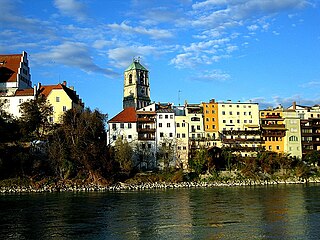
Wasserburg am Inn is a town in Rosenheim district in Upper Bavaria, Germany. The historic centre is a peninsula formed by the meandering river Inn. Many Medieval structures remain intact, giving the city a unique view.

Raubling Place in Bavaria, Germany

Raubling is a municipality in the district of Rosenheim, in Bavaria, Germany. It is situated on the western bank of the river Inn, 7 km south of Rosenheim.

Prien am Chiemsee Place in Bavaria, Germany

Prien am Chiemsee is a municipality in the Upper Bavarian district of Rosenheim in Germany. The town is a certified air and Kneipp spa on the western shore of the lake of Chiemsee, 16 km (9.3 mi) east of Rosenheim.

Feldkirchen-Westerham Place in Bavaria, Germany

Feldkirchen-Westerham is a municipality in the district of Rosenheim, in Bavaria, Germany. It is situated 22 km west of Rosenheim.

Gstadt am Chiemsee Place in Bavaria, Germany

Gstadt am Chiemsee is a municipality in the district of Rosenheim, Bavaria, Germany. It is located on lake Chiemsee.

Aßling Place in Bavaria, Germany

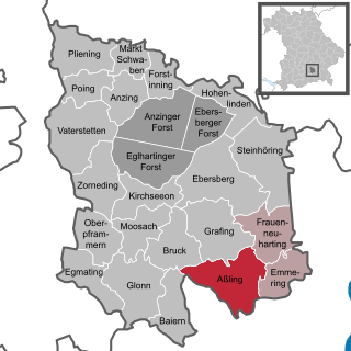
Aßling is a municipality in the district of Ebersberg, Upper Bavaria, Germany. It is, along with the communities of Emmering and Frauenneuharting, a member of the administrative community of the same name.

Haag in Oberbayern Place in Bavaria, Germany

Haag in Oberbayern is a municipality in the district of Mühldorf in Bavaria in Germany, in December 2013 the municipality had a population of 6359.

Amerang Place in Bavaria, Germany

Amerang is a municipality in the district of Rosenheim in Bavaria in Germany.

Babensham Place in Bavaria, Germany

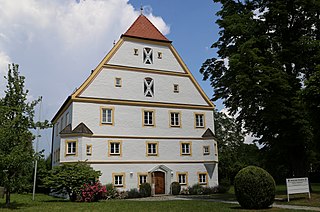
Babensham is a municipality in the district of Rosenheim in Bavaria in Germany. It lies on the river Inn.

Griesstätt Place in Bavaria, Germany

Griesstätt is a municipality in the district of Rosenheim in Bavaria, Germany. It lies on the river Inn.

Nußdorf am Inn Place in Bavaria, Germany

Nußdorf am Inn is a municipality in the district of Rosenheim in the state of Bavaria in Germany. Nußdorf consists of 23 boroughs and is a tourist destination in the Inn Valley between the Heuberg Wendelstein mountains on the Tyrol border. Nußdorf town center has Baroque churches and traditional farm houses.

Ramerberg Place in Bavaria, Germany

Ramerberg is a municipality in the district of Rosenheim in Bavaria in Germany. It lies on the river Inn.

Rimsting Place in Bavaria, Germany

Rimsting is a municipality in the district of Rosenheim in Bavaria in Germany. It lies on the shore of Lake Chiemsee between the municipalities of Prien am Chiemsee and Bad Endorf.

Schechen Place in Bavaria, Germany

Schechen is a municipality in the district of Rosenheim in Bavaria in Germany. It lies on the river Inn.

Soyen Place in Bavaria, Germany

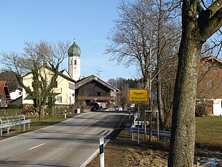
Soyen is a municipality in the district of Rosenheim in Bavaria in Germany. It lies on the river Inn.

Vogtareuth Place in Bavaria, Germany

Vogtareuth is a municipality in the district of Rosenheim in Bavaria in Germany. It lies on the river Inn.

Pfaffing Place in Bavaria, Germany

Pfaffing is a municipality in the district of Rosenheim in Bavaria in Germany.

Halfing Place in Bavaria, Germany

Halfing is a municipality in the district of Rosenheim in Bavaria in Germany. It is located in the western part of the Chiemgau area, half-way between Chiemsee and Wasserburg am Inn.

Rott am Inn Place in Bavaria, Germany

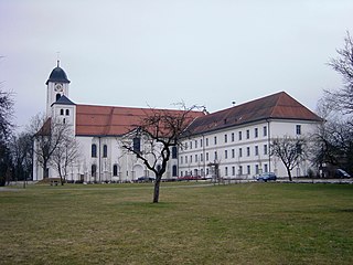
Rott am Inn is a municipality in the district of Rosenheim in Bavaria in Germany. It lies on the river Inn.

References

  1. Liste der ersten Bürgermeister/Oberbürgermeister in kreisangehörigen Gemeinden, Bayerisches Landesamt für Statistik, 15 July 2021.
  2. "Tabellenblatt "Daten 2", Statistischer Bericht A1200C 202041 Einwohnerzahlen der Gemeinden, Kreise und Regierungsbezirke". Bayerisches Landesamt für Statistik und Datenverarbeitung (in German). June 2021.