Stephanskirchen

Last updated
Stephanskirchen
Wallfahrtskirche St. Leonhard 8.jpg
Pilgrimage Church of Saint Leonhard
DEU Stephanskirchen COA.svg
Location of Stephanskirchen within Rosenheim district
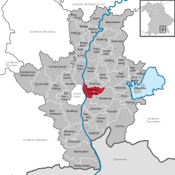
Stephanskirchen in RO.svgRotter Forst-SüdRotter Forst-NordEdlingRohrdorf
Germany adm location map.svg
Red pog.svg
Stephanskirchen
Bavaria location map.svg
Red pog.svg
Stephanskirchen
Coordinates: 47°51′N12°11′E / 47.850°N 12.183°E / 47.850; 12.183 Coordinates: 47°51′N12°11′E / 47.850°N 12.183°E / 47.850; 12.183
Country Germany
State Bavaria
Admin. region Oberbayern
District Rosenheim
Government
   Mayor (202026) Karl Mair [1]
Area
  Total26.51 km2 (10.24 sq mi)
Highest elevation
502 m (1,647 ft)
Lowest elevation
476 m (1,562 ft)
Population
 (2021-12-31) [2]
  Total10,643
  Density400/km2 (1,000/sq mi)
Time zone UTC+01:00 (CET)
  Summer (DST) UTC+02:00 (CEST)
Postal codes
83071
Dialling codes 08031, 08036
Vehicle registration RO
Website www.stephanskirchen.de

Stephanskirchen (Central Bavarian : Steffeskirch) is a municipality in the district of Rosenheim, Upper Bavaria in Germany.

Contents

Geography

fence, encircling an erratic boulder Findling Stephanskirchen.jpg
fence, encircling an erratic boulder

Stephanskirchen is located on a glacially formed[ citation needed ] plateau. The Inn river on the west and the lake Simssee are natural boundaries. The valley of the Sims river is a natural border at the south. North to Stephanskirchen are several forests and small lakes. The municipality is located within the Rosenheim-basin in the area of the former Inn Glacier. Therefore, numerous erratic boulders can be found here.

Subdivisions

The municipality is by population the third largest in the district of Rosenheim and consists of 48 parts ( Ortsteile ). Major settlements are Schloßberg and Haidholzen. Further settlements are: Baierbach, Eckenholz, Eichbichl, Eitzing, Entleiten, Fussen, Gehering, Graben, Grasweg, Haiden, Hofau, Hofleiten, Hofmühle, Högering, Höhensteig, Innleiten, Kieling, Kleinholzen, Kohlhaufmühle, Kragling, Kreut, Kronstauden, Krottenhausmühle, Kuglmoos, Lack, Landl, Landlmühle, Lauterbacherfilze, Leiten, Leonhardspfunzen, Murnau, Neumühle, Oed, Pulvermühle, Puster, Reikering, Schömering, Sims, Simserfilze, Simssee, Sonnenholz, Stephanskirchen, Waldering, Weinberg, Westerndorf, Westerndorferfilze and Ziegelberg.

Emblem

The emblem of Stephanskirchen was created in 1954 and indicates the historic dispartment: The holy Stephanus at the top symbolizes with his holy halo the area of Stephanskirchen. He holds a golden missal with tree golden stones in his left arm. The lower part of the emblem reminds of a dinghy, a so called "Mutze". This is because in the past the major source of income in Schloßberg, Hofleiten and close to the inn-shore was fishing and shipping. The dominant green color within the emblem points to the agricultural structure of Stephanskirchen.

History

water colour of Rosenheim castle, painted around 1900 by Michael Kotz, based on old templates Schloss Rosenheim.jpg
water colour of Rosenheim castle, painted around 1900 by Michael Kotz, based on old templates
The "Pestkreuz" in the forest of Kieling Pestkreuz Kieling.jpg
The "Pestkreuz" in the forest of Kieling
Memorial stone, reminding of those who were imprisoned here during world war two Haidholzen 1.jpg
Memorial stone, reminding of those who were imprisoned here during world war two
Entrance doors to the former Flak-Casern Haidholzen 2.jpg
Entrance doors to the former Flak-Casern

The oldest traces were dated third and fourth century BC and can be found in the Doblergraben and at the Ziegelberg. An old Roman road crossed the River Inn at Leonhardspfunzen. The bridge was called "pons aeni" and headed westwards towards Augsburg. The first reports of a Christian church in the area around Sims are dated at 790 AD (ecclesia ad sinsa). Stephanskirchen was first mentioned in a record in the year 1130 where it was named "stevenchirgen". On the Schlossberg there was the Rosenheim castle which was first mentioned in the year 1234. It was used for administration and as a legal court of the Wittelsbacher; at the beginning of the 19th century it deteriorated.

Plague epidemic of the Middle Ages took their toll in Stephanskirchen, too. In the forest between Kieling and Baierbach a memorial stone can be found which got placed in memory of those who got buried there. The inscription reads:

Während des Dreißigjährigen Krieges im Jahr 1632 herrschte in den Ortschaften der Umgebung die Pest. Viele Menschen starben an dieser Krankheit und wurden hier an diesem stillen Ort in Massengräbern bestattet. Der Überlieferung nach sind ganze Ortschaften ausgestorben. In Kieling blieb nur ein kleines Mädchen übrig. Dieses steinerne Kreuz wurde zum Gedenken an die Toten aufgestellt. (Geschichtlich überliefert durch Pfarrer Angerer, Stephanskirchen).

Translated it says:
In the year 1632 during the Thirty Years' War a plague epidemic ruled in the surrounding villages. Many humans died due to that disease and got buried in mass graves at this silent place. According to historical tradition, entire villages have died out. In Kieling only a little girl survived. This stone cross was erected to commemorate the dead. (Historically handed down by Pastor Angerer, Stephanskirchen).

Rural structures were predominant in the ancestor areas of the municipality Stephanskirchen up to the 18th century. Stephanskirchen and the newly developed workers and day labourer housing estate Hofleiten became autonoumous political communities through the Bavarian administrative reform of the year 1818. In 1854 Hofleiten and Stephanskirchen got unified. Due to the social differences fierce conflicts between parts of the community persisted until the late 19th century. Since 1900 Schloßberg became the largest part of the municipality due to its vicinity to Rosenheim.

Between 1944 and March 31, 1945 in the district Haidholzen there was a subcamp of the Dachau concentration camp housing around 6000 prisoners. Polish (Jewish), Russian and French concentration camp prisoners were captured in a large barrack settlement within the area. One main building of this concentration camp exists until today; since 1947 there are manufacturing facilities of a candy factory. [3] The prisoners worked for regional contractors and for the "Chiemgauer Vertriebsgesellschaft O.H.G.", which was a subsidiary of the company BMW. They produced plane engines there but never fully went into production. Several independent sources report about homicides of the imprisoned people. By the end of 1944 the production plant became a target of air attacks during which two employees were killed. 30% of the buildings and 20% of the machinery were destroyed, the created damage was rated 250,000  ℛℳ. By command of Heinrich Himmler an evacuation into rearward concentration camps started in March and April 1945 during which many prisoners died due to exhaustion or being shot by the SS. [4]

After the end of World War II around 1500 refugees and expellees came to Stephanskirchen and founded the settlement Haidholzen close to the former so called "flak casern" (propaganda term, even used after WWII). Streets named "Schlesier straße" or "Sudetenland straße" remind up to today of the origin of these people.

Famous people

Companies and infrastructure

Two internationally known companies can be found in Stephanskirchen: Marc O'Polo, which has its international headquarters there, and ARRI.

Otfried-Preussler-Schule Otfried-Preussler-Schule 1.jpg
Otfried-Preußler-Schule
Otfried-Preussler-Schule Otfried-Preussler-Schule 2.jpg
Otfried-Preußler-Schule

In 1978 an elementary school was opened in Stephanskirchen; like 7 other schools in Germany it is named in honor of the author Otfried Preußler, who lives in Haidholzen. The Otfried-Preußler-Schule is the only currently participating UNESCO project school of all schools in Bavaria. Around 550 pupils are spread amongst 25 classes. The elementary school has 8 classes and the "Hauptschule" has 17 classes; of those, 6 lead to a secondary school level certificate. An after-school supervision is offered by the "Arche"-association.

In Schloßberg there is the "Volksschule Schloßberg", an elementary school hosting about 200 pupils.

There are four Kindergartens in Stephanskirchen. The Catholic Kindergarten "St. Georg" in Schloßberg, the Catholic Kindergarten "Sonnenschein" in Haidholzen, the Catholic Church Kindergarten "Bärenstube" in Stephanskirchen and the Protestant Kindergarten "Regenbogen" in Schloßberg. [5]

In 2003 a new town hall was opened in Schloßberg.

Tourist attractions

Related Research Articles

<span class="mw-page-title-main">Rohrdorf, Bavaria</span> Municipality in Bavaria, Germany

Rohrdorf is a municipality in the district of Rosenheim in Upper Bavaria, Germany. It is located in the Inn valley.

<span class="mw-page-title-main">Rosenheim</span> Town in Bavaria, Germany

Rosenheim is a city in Bavaria, Germany. It is an independent city located in the centre of the district of Rosenheim, and is also the seat of its administration. It is located on the west bank of the Inn at the confluence of the rivers Inn and Mangfall, in the Bavarian Alpine Foreland. It is the third largest city in Upper Bavaria with over 63,000 inhabitants. Rosenheim is the economic centre and the busiest place in the region.

Otfried Preußler was a German children's books author. More than 50 million copies of his books have been sold worldwide and they have been translated into 55 languages. His best-known works are The Robber Hotzenplotz and The Satanic Mill (Krabat).

<span class="mw-page-title-main">Świecko</span> Village in Lubusz Voivodeship, Poland

Świecko is a village in the administrative district of Gmina Słubice, within Słubice County, Lubusz Voivodeship, in western Poland, close to Frankfurt an der Oder on the German border. It lies approximately 6 kilometres (4 mi) south of Słubice, 66 km (41 mi) south-west of Gorzów Wielkopolski, and 74 km (46 mi) north-west of Zielona Góra. The village has a population of 183 (2016).

<span class="mw-page-title-main">Plandište</span> Village and municipality in Vojvodina, Serbia

Plandište is a village and municipality located in the South Banat District of the autonomous province of Vojvodina, Serbia. The village has a population of 3,832, while Plandište municipality has 11,336 inhabitants. One of municipality's best known landmarks is Kapetanovo Castle, located in Stari Lec.

<span class="mw-page-title-main">Blankenburg (Harz)</span> Town in Saxony-Anhalt, Germany

Blankenburg (Harz) is a town and health resort in the district of Harz, in Saxony-Anhalt, Germany, at the north foot of the Harz Mountains, 12 miles (19 km) southwest of Halberstadt.

<span class="mw-page-title-main">Marienberg</span> Town in Saxony, Germany

Marienberg is a town in Germany. It was the district capital of the Mittlerer Erzgebirgskreis in the southern part of Saxony, and since August 2008 it has been part of the new district of Erzgebirgskreis. As of 2020, the town had 16,716 inhabitants.

<span class="mw-page-title-main">Bad Schmiedeberg</span> Town in Saxony-Anhalt, Germany

Bad Schmiedeberg is a small town in the Wittenberg district of Saxony-Anhalt, Germany. It lies within the Düben Heath Nature Park.

<span class="mw-page-title-main">Schiltach</span> Town in Baden-Württemberg, Germany

Schiltach is a town in the district of Rottweil, in Baden-Württemberg, Germany. It is situated in the eastern Black Forest, on the river Kinzig, 20 km south of Freudenstadt.

<span class="mw-page-title-main">Veringenstadt</span> Town in Baden-Württemberg, Germany

Veringenstadt is a town in the district of Sigmaringen, in Baden-Württemberg, Germany. It is situated 10 km north of Sigmaringen.

<span class="mw-page-title-main">Arnschwang</span> Municipality in Bavaria, Germany

Arnschwang is a rural municipality in the district of Cham in Bavaria, Germany. The population was 2,004 as of the 2010 census. In recent years Arnschwang has focused on the production of environmentally friendly energy from biomass and water.

<span class="mw-page-title-main">Castell, Bavaria</span> Municipality in Bavaria, Germany

Castell is a municipality in the district of Kitzingen in Bavaria in Germany. It was the seat of the Counts of Castell. Today it is part of the municipal association Wiesentheid. It has around 800 inhabitants.

<span class="mw-page-title-main">Bad Feilnbach</span> Municipality in Bavaria, Germany

Bad Feilnbach is a municipality in the Upper Bavarian district of Rosenheim at the foot of Wendelstein Mountain in Germany. As a famous 'Moorheilbad' the municipality was awarded in 1973 the title "Bad". Since the 19th century the peat deposits were the basis for a continued expansion of the spa and health facilities. The recognized healing success of "black gold" on a variety of diseases were the basis for the development of a well-known spa and tourist community. Due to its wooded surroundings and the mild climate Feilnbach is called the "Bavarian Meran". The entire municipality is recognized as a healing spa resort except for parts of the former municipality Dettendorf.

Traiskirchen is a city and Municipality in the district of Baden in Lower Austria in Austria. It is 20 km south of Vienna, in the Thermenlinie region, known for its wine and heurigers. Traiskirchen is home to the Traiskirchen Lions basketball team. The town has the oldest public astronomical observatory in Lower Austria. The city is also known for its refugee camp the "Bundesbetreuungsstelle für Asylwerber".

<span class="mw-page-title-main">Kleinzell</span> Place in Lower Austria, Austria

Kleinzell is a town in the district of Lilienfeld in the Austrian state of Lower Austria.

Erlbach-Kirchberg is a former municipality in the district Erzgebirgskreis, in Saxony, Germany. Since 1 January 2013, it is part of the town Lugau.

<span class="mw-page-title-main">Obdach</span> Place in Styria, Austria

Obdach is a municipality in the district of Murtal in Styria, Austria.

Grilë is a settlement in the former Gruemirë municipality, Shkodër County, northern Albania. At the 2015 local government reform it became part of the municipality Malësi e Madhe. It is part of the Vraka region, and is inhabited by a minority of Montenegrins, who call the village Grilj.

Buchberg is the name of the following places:

<span class="mw-page-title-main">Leutschach an der Weinstraße</span> Place in Styria, Austria

Leutschach an der Weinstraße is since January 2015 a new municipality with 3,794 residents in the Leibnitz District of Styria, Austria.

References

  1. Liste der ersten Bürgermeister/Oberbürgermeister in kreisangehörigen Gemeinden, Bayerisches Landesamt für Statistik, 15 July 2021.
  2. "Tabelle 12411-003r Fortschreibung des Bevölkerungsstandes: Gemeinden, Stichtag" (in German). Bayerisches Landesamt für Statistik. June 2022.
  3. History of the sweets company PIT Süsswaren Homepage with picture of a former casern building Archived 2011-07-19 at the Wayback Machine
  4. "Rosenheim im Dritten Reich; Beiträge zur Stadtgeschichte", published by "Kulturamt der Stadt Rosenheim 1989"
  5. Gemeindebroschüre der Gemeinde Stephanskirchen PDF, 12MB [ permanent dead link ]