Alcalde, New Mexico

Last updated

Alcalde, New Mexico
CDP
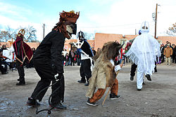
Los Matachines de Alcalde.jpg
Los Matachines de Alcalde, 2013
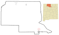
Rio Arriba County New Mexico Incorporated and Unincorporated areas Alcalde Highlighted.svg
Location of Alcalde, New Mexico
Usa edcp location map.svg
Red pog.svg
Alcalde, New Mexico
Location in the United States
Coordinates: 36°05′07″N106°03′27″W / 36.08528°N 106.05750°W / 36.08528; -106.05750
Country United States
State New Mexico
County Rio Arriba
Area
[1]
  Total
0.52 sq mi (1.34 km2)
  Land0.52 sq mi (1.34 km2)
  Water0.00 sq mi (0.00 km2)
Elevation
[2]
5,693 ft (1,735 m)
Population
 (2020) [3]
  Total
310
  Density600.78/sq mi (231.90/km2)
Time zone UTC-7 (Mountain (MST))
  Summer (DST) UTC-6 (MDT)
ZIP code
87511
Area code 505
FIPS code 35-02070
GNIS feature ID2407711 [2]

Alcalde (Spanish for mayor) is a census-designated place (CDP) in Rio Arriba County, New Mexico, United States. In 2022, the Census Bureau lists the population at 235. [4]

Contents

Places to Visit

History

Each year on December 27, the city of Alcalde celebrates a feast day. One prominent focus of the celebration is when villagers enact Los Comanches, a poetic drama written 1780. The performance, based on true events, depicts the Spanish army's defeat of Comanche leader, Green Horn. [7]

Juan De Oñate

Juan de Oñate, nicknamed The Last Conquistador, lead the final Spanish funded colonization venture of nearly 500 people to colonize the area of northern New Mexico in 1598. [8]

In the summer of 2020, two statues of Juan de Oñate were taken down amid longstanding tensions between Native Americans and Hispanics over Spain’s conquest of New Mexico. Gunfire erupted during a protest in Albuquerque, where demonstrators called for the removal of a statue of Oñate, the tyrannical conquistador whose legacy has become a focal point in the wider national movement to confront racial injustice. While protests across the country have targeted various symbols of oppression, including statues of Christopher Columbus, the focus in New Mexico is shifting toward challenging symbols of colonial violence.

Earlier that day, authorities in the northern town of Alcalde removed another statue of Oñate, whose harsh rule as governor played a pivotal role in establishing centuries of Spanish control in the region. [9]

Georgia O'Keeffe

Renowned artist Georgia O'Keeffe created the oil painting titled "Near Alcalde, New Mexico, 1931" as a depiction of the Spanish Mission Church just outside of Alcalde. The painting is now housed in the Yale University Art Gallery. [10]

Geography

According to the United States Census Bureau, the CDP has a total area of 0.5 square miles (1.3 km2), all land. [11]

Climate

Climate data for Alcalde, New Mexico, 1991–2020 normals, extremes 1953present
MonthJanFebMarAprMayJunJulAugSepOctNovDecYear
Record high °F (°C)70
(21)
73
(23)
83
(28)
88
(31)
98
(37)
101
(38)
102
(39)
100
(38)
95
(35)
90
(32)
79
(26)
68
(20)
102
(39)
Mean maximum °F (°C)58.1
(14.5)
64.7
(18.2)
74.7
(23.7)
80.9
(27.2)
88.4
(31.3)
95.6
(35.3)
96.6
(35.9)
93.6
(34.2)
89.5
(31.9)
81.7
(27.6)
69.3
(20.7)
58.4
(14.7)
97.5
(36.4)
Mean daily maximum °F (°C)45.1
(7.3)
51.0
(10.6)
60.0
(15.6)
67.4
(19.7)
76.2
(24.6)
86.0
(30.0)
88.1
(31.2)
85.6
(29.8)
79.8
(26.6)
68.7
(20.4)
55.4
(13.0)
44.5
(6.9)
67.3
(19.6)
Daily mean °F (°C)30.2
(−1.0)
35.3
(1.8)
42.4
(5.8)
49.6
(9.8)
58.1
(14.5)
67.1
(19.5)
71.8
(22.1)
69.6
(20.9)
62.2
(16.8)
50.3
(10.2)
38.7
(3.7)
29.8
(−1.2)
50.4
(10.2)
Mean daily minimum °F (°C)15.3
(−9.3)
19.6
(−6.9)
24.8
(−4.0)
31.9
(−0.1)
39.9
(4.4)
48.2
(9.0)
55.4
(13.0)
53.7
(12.1)
44.6
(7.0)
31.9
(−0.1)
22.0
(−5.6)
15.2
(−9.3)
33.5
(0.8)
Mean minimum °F (°C)4.5
(−15.3)
8.5
(−13.1)
13.8
(−10.1)
20.9
(−6.2)
29.0
(−1.7)
38.5
(3.6)
46.5
(8.1)
45.9
(7.7)
33.5
(0.8)
21.5
(−5.8)
11.0
(−11.7)
5.0
(−15.0)
1.4
(−17.0)
Record low °F (°C)−34
(−37)
−12
(−24)
4
(−16)
11
(−12)
18
(−8)
32
(0)
39
(4)
34
(1)
23
(−5)
9
(−13)
−11
(−24)
−11
(−24)
−34
(−37)
Average precipitation inches (mm)0.51
(13)
0.39
(9.9)
0.69
(18)
0.70
(18)
0.78
(20)
0.78
(20)
1.65
(42)
1.75
(44)
1.25
(32)
1.14
(29)
0.73
(19)
0.73
(19)
11.10
(282)
Average snowfall inches (cm)2.2
(5.6)
1.5
(3.8)
1.4
(3.6)
0.3
(0.76)
0.0
(0.0)
0.0
(0.0)
0.0
(0.0)
0.0
(0.0)
0.0
(0.0)
0.6
(1.5)
1.4
(3.6)
3.3
(8.4)
10.7
(27.26)
Average precipitation days (≥ 0.01 in)2.83.03.84.14.23.98.28.55.44.93.13.355.2
Average snowy days (≥ 0.1 in)1.31.10.50.30.00.00.00.00.00.20.51.75.6
Source 1: NOAA [12]
Source 2: National Weather Service [13]

Demographics

Historical population
CensusPop.Note
2020 310
U.S. Decennial Census [14] [3]

At the 2000 census there were 377 people, 121 households, and 99 families in the CDP. The population density was 735.3 inhabitants per square mile (283.9/km2). There were 138 housing units at an average density of 269.2 per square mile (103.9/km2). The racial makeup of the CDP was 37.40% White, 0.27% African American, 1.59% Native American, 0.27% Asian, 54.64% from other races, and 5.84% from two or more races. Hispanic or Latino of any race were 89.12%. [15]

Of the 121 households 46.3% had children under the age of 18 living with them, 52.1% were married couples living together, 19.8% had a female householder with no husband present, and 17.4% were non-families. 16.5% of households were one person and 7.4% were one person aged 65 or older. The average household size was 3.12 and the average family size was 3.39.

The age distribution was 32.9% under the age of 18, 7.2% from 18 to 24, 32.1% from 25 to 44, 15.4% from 45 to 64, and 12.5% 65 or older. The median age was 31 years. For every 100 females, there were 95.3 males. For every 100 females age 18 and over, there were 99.2 males.

The median household income was $37,969 and the median family income was $38,250. Males had a median income of $31,375 versus $20,341 for females. The per capita income for the CDP was $13,656. About 10.7% of families and 12.6% of the population were below the poverty line, including 8.6% of those under age 18 and 13.6% of those age 65 or over.

Education

It is in Española Public Schools. [16] Alcalde has one elementary school, Alcalde Elementary. The comprehensive public high school is Española Valley High School.

See also

Related Research Articles

<span class="mw-page-title-main">Sandoval County, New Mexico</span> County in New Mexico, United States

Sandoval County is a county located in the U.S. state of New Mexico. As of the 2020 census, the population was 148,834, making it the fourth-most populous county in New Mexico. The county seat is Bernalillo.

<span class="mw-page-title-main">Rio Arriba County, New Mexico</span> County in New Mexico, United States

Rio Arriba County is a county in the U.S. state of New Mexico. As of the 2020 census, the population was 40,363. Its county seat is Tierra Amarilla. Its northern border is the Colorado state line.

<span class="mw-page-title-main">Carnuel, New Mexico</span> Census-designated place in New Mexico, United States

Carnuel is a census-designated place (CDP) in Bernalillo County, New Mexico, United States. The population was 1,232 at the 2010 Census. It is part of the Albuquerque Metropolitan Statistical Area.

<span class="mw-page-title-main">Chilili, New Mexico</span> Census-designated place in New Mexico, United States

Chilili is a census-designated place in Bernalillo County, New Mexico, United States. The population was 137 at the 2010 census. It is part of the Albuquerque Metropolitan Statistical Area.

<span class="mw-page-title-main">Dulce, New Mexico</span> Census-designated place in New Mexico, United States

Dulce is a census-designated place (CDP) in Rio Arriba County, New Mexico, United States. The population was 2,743 at the 2010 census, almost entirely Native American. It is the largest community and tribal headquarters of the Jicarilla Apache Reservation.

<span class="mw-page-title-main">San Juan, New Mexico</span> CDP in New Mexico, United States

San Juan or San Juan Pueblo is a census-designated place (CDP) in Rio Arriba County, New Mexico, United States. The population was 592 at the 2000 census.

<span class="mw-page-title-main">Cochiti, New Mexico</span> CDP in New Mexico, United States

Cochiti is a census-designated place (CDP) in Sandoval County, New Mexico, United States. A historic pueblo of the Cochiti people, one of the Keresan Nations, it is part of the Albuquerque Metropolitan Statistical Area. The population was 528 at the 2010 census. Located 22 miles (35 km) southwest of Santa Fe, the community is listed as a historic district on the National Register of Historic Places.

<span class="mw-page-title-main">Agua Fria, New Mexico</span> CDP in New Mexico, United States

Agua Fria is a census-designated place (CDP) in Santa Fe County, New Mexico, United States. It is part of the Santa Fe, New Mexico Metropolitan Statistical Area. The population was 2,800 at the 2010 census. Agua Fria Village is a "Traditional Historic Community" (THC) as designated by the Santa Fe Board of County Commissioners in 1995 and subsequent Santa Fe County Ordinance #1996-16, as allowed by State Statute.

<span class="mw-page-title-main">Cañada de los Alamos, New Mexico</span> CDP in New Mexico, United States

Cañada de los Alamos is a census-designated place (CDP) in Santa Fe County, New Mexico, United States. It is part of the Santa Fe, New Mexico Metropolitan Statistical Area. The population was 434 at the 2010 census.

<span class="mw-page-title-main">Cuyamungue, New Mexico</span> Census-designated place in New Mexico, United States

Cuyamungue is a census-designated place (CDP) in Santa Fe County, New Mexico, United States. It is part of the Santa Fe, New Mexico Metropolitan Statistical Area. The population was 479 at the 2010 census.

<span class="mw-page-title-main">Galisteo, New Mexico</span> CDP in New Mexico, United States

Galisteo is a census-designated place (CDP) in Santa Fe County, New Mexico, United States. It is part of the Santa Fe, New Mexico Metropolitan Statistical Area. The population was 253 at the 2020 census.

<span class="mw-page-title-main">Santa Cruz, New Mexico</span> CDP in New Mexico, United States

Santa Cruz, historically known as Santa Cruz de la Cañada, is a census-designated place (CDP) in Santa Fe County, New Mexico, United States. It is part of the Santa Fe, New Mexico Metropolitan Statistical Area. The population was 423 at the 2000 census.

<span class="mw-page-title-main">Picuris Pueblo, New Mexico</span> CDP in New Mexico, United States

Picuris Pueblo is a historic pueblo in Taos County, New Mexico, United States. The federally recognized tribe of Pueblo people inhabit the community. Picurís Pueblo is a member of the Eight Northern Pueblos. Their own name for their pueblo is P'įwweltha, meaning "mountain warrior place" or "mountain pass place." They speak the Picuris dialect of the Northern Tiwa language, part of the Kiowa-Tanoan language family. For statistical purposes, the United States Census Bureau has defined that community as a census-designated place (CDP). The 2010 census estimated that 68 people lived in the CDP, while 267 people in the U.S. reported being of the tribal group Picuris alone and 439 reported being of the tribal group Picuris alone or in combination with other groups.

<span class="mw-page-title-main">Ranchos de Taos, New Mexico</span> Census-designated place in Taos County, New Mexico, United States

Ranchos de Taos is a census-designated place (CDP) in Taos County, New Mexico United States. The population was 2,390 at the time of the 2000 census.

<span class="mw-page-title-main">Peralta, New Mexico</span> Town in New Mexico, United States

Peralta is a town in Valencia County, New Mexico, United States. Prior to its incorporation on July 1, 2007, it was a census-designated place (CDP). The population was 3,660 as of the 2010 census. Peralta is part of the Albuquerque metropolitan area.

<span class="mw-page-title-main">San Elizario, Texas</span> City in Texas, United States

San Elizario is a city in El Paso County, Texas, United States. Its population was 10,116 at the 2020 census. It is part of the El Paso metropolitan statistical area. It lies on the Rio Grande, which forms the border between the United States and Mexico. The city of Socorro adjoins it on the west and the town of Clint lies to the north.

<span class="mw-page-title-main">Chimayo, New Mexico</span> CDP in New Mexico, United States

Chimayo is a census-designated place (CDP) in Rio Arriba and Santa Fe counties in the U.S. state of New Mexico. The name is derived from a Tewa name for a local landmark, the hill of Tsi Mayoh. The town is unincorporated and includes many neighborhoods, called plazas or placitas, each with its own name, including El Potrero de Chimayó and the Plaza del Cerro. The cluster of plazas called Chimayo lies near Santa Cruz, approximately 25 miles north of Santa Fe. The population was 3,177 at the 2010 census.

<span class="mw-page-title-main">Española, New Mexico</span> City in New Mexico, United States

Española is a city primarily in Rio Arriba County, New Mexico, United States. A portion of the central and eastern section of the city is in Santa Fe County. Founded as a railroad village some distance from the old Indian town of San Juan de los Caballeros, it was named Española and officially incorporated in 1925. It has been called the first capital city in the United States. As of the 2020 census, the population was at 10,526. Española is within the Albuquerque–Santa Fe–Los Alamos combined statistical area.

<span class="mw-page-title-main">Ohkay Owingeh, New Mexico</span> Pueblo in Rio Arriba County, New Mexico

Ohkay Owingeh, known by its Spanish name as San Juan Pueblo from 1589 to 2005, is a pueblo in Rio Arriba County, New Mexico. For statistical purposes, the United States Census Bureau has defined that community as a census-designated place (CDP). Ohkay Owingeh is also the federally recognized tribe of Pueblo people inhabiting the town.

Velarde is a census-designated place (CDP) in Rio Arriba County, New Mexico, United States. The population was 502 at the time of the 2010 census. Velarde is located on New Mexico State Road 68, in the Rio Grande Rift, at the point where the road enters the Rio Grande Gorge.

References

  1. "ArcGIS REST Services Directory". United States Census Bureau. Retrieved October 12, 2022.
  2. 1 2 U.S. Geological Survey Geographic Names Information System: Alcalde, New Mexico
  3. 1 2 "Census Population API". United States Census Bureau. Retrieved October 12, 2022.
  4. "Alcalde, NM | Data USA". datausa.io. Retrieved December 8, 2024.
  5. Pike, David (2015). Roadside New Mexico : a guide to historic markers. University of New Mexico Press. p. 383.
  6. "State Fair |" . Retrieved December 8, 2024.
  7. Whitmore, Jane (December 27, 2020). "Los Comanches Drama Performed in Alcalde, New Mexico". The Bikini Project. Retrieved December 8, 2024.
  8. Oxford University Press. "The American Historical Review". The American Historical Review. 99: 636–637 via JSOTR.
  9. Romero, Simon (June 15, 2020). "Man Is Shot at Protest Over Statue of New Mexico's Conquistador". The New York Times. Retrieved November 11, 2024.
  10. "Near Alcalde, New Mexico | Yale University Art Gallery". artgallery.yale.edu. Retrieved December 8, 2024.
  11. "2010 Census Gazetteer Files – Places: New Mexico". U.S. Census Bureau . Retrieved October 20, 2017.
  12. "U.S. Climate Normals Quick Access – Station: Alcalde, NM". National Oceanic and Atmospheric Administration. Retrieved February 25, 2023.
  13. "NOAA Online Weather Data – NWS Albuquerque". National Weather Service. Retrieved February 25, 2023.
  14. "Census of Population and Housing". Census.gov. Retrieved June 4, 2016.
  15. "U.S. Census website". United States Census Bureau . Retrieved January 31, 2008.
  16. "2020 CENSUS - SCHOOL DISTRICT REFERENCE MAP: Rio Arriba County, NM" (PDF). U.S. Census Bureau . Retrieved July 30, 2021.