Altona Township, Pipestone County, Minnesota

Last updated

Altona Township, Minnesota
USA Minnesota location map.svg
Red pog.svg
Altona Township, Minnesota
Location within the state of Minnesota
Usa edcp location map.svg
Red pog.svg
Altona Township, Minnesota
Altona Township, Minnesota (the United States)
Coordinates: 44°9′7″N96°23′6″W / 44.15194°N 96.38500°W / 44.15194; -96.38500
Country United States
State Minnesota
County Pipestone
Area
  Total43.1 sq mi (111.5 km2)
  Land43.1 sq mi (111.5 km2)
  Water0.0 sq mi (0.0 km2)
Elevation
1,683 ft (513 m)
Population
 (2000)
  Total192
  Density4.5/sq mi (1.7/km2)
Time zone UTC-6 (Central (CST))
  Summer (DST) UTC-5 (CDT)
FIPS code 27-01216 [1]
GNIS feature ID0663421 [2]

Altona Township is a township in Pipestone County, Minnesota, United States. The population was 192 at the 2000 census.

Contents

Altona Township was organized in 1880, and named after Altoona, Pennsylvania. [3]

Geography

According to the United States Census Bureau, the township has a total area of 43.0 square miles (111 km2), all land.

Demographics

As of the census [1] of 2000, there were 192 people, 63 households, and 51 families residing in the township. The population density was 4.5 inhabitants per square mile (1.7/km2). There were 69 housing units at an average density of 1.6 per square mile (0.62/km2). The racial makeup of the township was 100.00% White.

There were 63 households, out of which 47.6% had children under the age of 18 living with them, 74.6% were married couples living together, 3.2% had a female householder with no husband present, and 19.0% were non-families. 19.0% of all households were made up of individuals, and 9.5% had someone living alone who was 65 years of age or older. The average household size was 3.05 and the average family size was 3.53.

In the township the population was spread out, with 36.5% under the age of 18, 6.3% from 18 to 24, 24.5% from 25 to 44, 20.3% from 45 to 64, and 12.5% who were 65 years of age or older. The median age was 33 years. For every 100 females, there were 97.9 males. For every 100 females age 18 and over, there were 106.8 males.

The median income for a household in the township was $26,250, and the median income for a family was $30,833. Males had a median income of $23,125 versus $18,750 for females. The per capita income for the township was $12,140. About 8.3% of families and 13.6% of the population were below the poverty line, including 22.4% of those under the age of eighteen and 9.5% of those sixty five or over.

Politics

Altona Township is located in Minnesota's 1st congressional district, represented by Mankato educator Tim Walz, a Democrat. At the state level, Altona Township is located in Senate District 22, represented by Republican Doug Magnus, and in House District 22A, represented by Republican Joe Schomacker.

Related Research Articles

Hines Township is a township in Beltrami County, Minnesota, United States. The population was 674 as of the 2000 census.

St. Mathias Township is a township in Crow Wing County, Minnesota, United States. The population was 490 at the 2000 census. St. Mathias Township took its name from a local Roman Catholic church.

Randolph Township is a township in Dakota County, Minnesota, United States. The population was 536 at the 2000 census.

Carrollton Township is a township in Fillmore County, Minnesota, United States. The population was 321 at the 2000 census.

Fillmore Township is a township in Fillmore County, Minnesota, United States. The population was 485 at the 2000 census.

Newburg Township is a township in Fillmore County, Minnesota, United States. The population was 444 at the 2000 census.

<span class="mw-page-title-main">Welch Township, Goodhue County, Minnesota</span> Township in Minnesota, United States

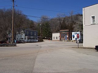
Welch Township is a township in Goodhue County, Minnesota, United States. It lies about halfway between the cities of Hastings and Red Wing and 36 miles southeast of Saint Paul. The population was 697 at the 2000 census. It is centered on the small community of Welch on the Cannon River. Like many river towns in the Driftless Area, it is situated at the base of the steep bluffs of the river valley.

Culdrum Township is a township in Morrison County, Minnesota, United States. The population was 505 at the 2000 census.

Leigh Township is a township in Morrison County, Minnesota, United States. The population was 192 at the 2000 census.

Buse Township is a township in Otter Tail County, Minnesota, United States. The population was 690 at the 2000 census.

Carlisle Township is a township in Otter Tail County, Minnesota, United States. The population was 219 as of the 2000 census.

Effington Township is a township in Otter Tail County, Minnesota, United States. The population was 297 at the 2000 census.

Highlanding Township is a township in Pennington County, Minnesota, United States. The population was 192 at the 2000 census.

Nickerson Township is a township in Pine County, Minnesota, United States. The population was 154 at the 2000 census.

King Township is a township in Polk County, Minnesota, United States. It is part of the Grand Forks-ND-MN Metropolitan Statistical Area. The population was 195 at the 2000 census.

Louisville Township is a township in Red Lake County, Minnesota, United States. The population was 192 at the 2000 census.

Cotton Township is a township in Saint Louis County, Minnesota, United States. The population was 445 at the 2010 census.

Kildare Township is a township in Swift County, Minnesota, United States. The population was 192 at the 2000 census.

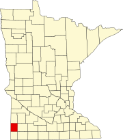
Shaokatan Township is a township in Lincoln County, Minnesota, United States. The population was 192 at the 2000 census.

Northome is an unorganized territory in Koochiching County, Minnesota, United States. The term "unorganized territory" is used by the United States Census Bureau to designate a portion of a county that is not included in any legally established minor civil division for the purpose of presenting statistical data. The population was 496 at the 2000 census.

References

  1. 1 2 "U.S. Census website". United States Census Bureau . Retrieved January 31, 2008.
  2. "US Board on Geographic Names". United States Geological Survey. October 25, 2007. Retrieved January 31, 2008.
  3. Upham, Warren (1920). Minnesota Geographic Names: Their Origin and Historic Significance. Minnesota Historical Society. p. 417.