Woodstock, Minnesota

Last updated

Woodstock, Minnesota
Pipestone County Minnesota Incorporated and Unincorporated areas Woodstock Highlighted.svg
Location of Woodstock, Minnesota
Coordinates: 44°00′40″N96°05′48″W / 44.01111°N 96.09667°W / 44.01111; -96.09667
CountryUnited States
State Minnesota
County Pipestone
PlattedSeptember 1879
Incorporated July 11, 1892
Government
   Mayor Austin Kruisselbrink
Area
[1]
  Total0.539 sq mi (1.397 km2)
  Land0.539 sq mi (1.397 km2)
  Water0.000 sq mi (0.000 km2)
Elevation
[2]
1,821 ft (555 m)
Population
 (2020) [3]
  Total110
  Estimate 
(2022) [4]
110
  Density204.08/sq mi (78.73/km2)
Time zone UTC–6 (Central (CST))
  Summer (DST) UTC–5 (CDT)
ZIP Code
56186
Area code 507
FIPS code 27-71680
GNIS feature ID2397373 [2]
Sales tax 6.875% [5]

Woodstock is a city in Pipestone County, Minnesota, United States. The population was 110 at the 2020 census. [3]

Contents

History

Woodstock was platted in September 1879. [6] The city was named after Woodstock, Illinois. [7] A post office has been in operation at Woodstock since 1879. [8] Woodstock was incorporated on July 11, 1892. [6]

Geography

According to the United States Census Bureau, the city has a total area of 0.539 square miles (1.40 km2), all land. [1]

Demographics

Historical population
CensusPop.Note
1900 211
1910 2267.1%
1920 27722.6%
1930 235−15.2%
1940 2537.7%
1950 2779.5%
1960 213−23.1%
1970 2171.9%
1980 180−17.1%
1990 159−11.7%
2000 132−17.0%
2010 124−6.1%
2020 110−11.3%
2022 (est.)110 [4] 0.0%
U.S. Decennial Census [9]
2020 Census [3]

2010 census

As of the 2010 census, there were 124 people, 55 households, and 30 families living in the city. The population density was 238.5 inhabitants per square mile (92.1/km2). There were 70 housing units at an average density of 134.6 per square mile (52.0/km2). The racial makeup of the city was 98.4% White, 0.8% Native American, and 0.8% Asian.

There were 55 households, of which 27.3% had children under the age of 18 living with them, 49.1% were married couples living together, 3.6% had a female householder with no husband present, 1.8% had a male householder with no wife present, and 45.5% were non-families. 36.4% of all households were made up of individuals, and 20% had someone living alone who was 65 years of age or older. The average household size was 2.25 and the average family size was 2.90.

The median age in the city was 45 years. 20.2% of residents were under the age of 18; 8% were between the ages of 18 and 24; 21.8% were from 25 to 44; 31.5% were from 45 to 64; and 18.5% were 65 years of age or older. The gender makeup of the city was 50.0% male and 50.0% female.

2000 census

As of the 2000 census, there were 132 people, 63 households, and 28 families living in the city. The population density was 238.3 inhabitants per square mile (92.0/km2). There were 72 housing units at an average density of 130.0 per square mile (50.2/km2). The racial makeup of the city was 99.24% White and 0.76% Native American.

There were 63 households, out of which 23.8% had children under the age of 18 living with them, 42.9% were married couples living together, 1.6% had a female householder with no husband present, and 54.0% were non-families. 50.8% of all households were made up of individuals, and 31.7% had someone living alone who was 65 years of age or older. The average household size was 2.08 and the average family size was 3.24.

In the city, the population was spread out, with 25.0% under the age of 18, 2.3% from 18 to 24, 31.1% from 25 to 44, 14.4% from 45 to 64, and 27.3% who were 65 years of age or older. The median age was 40 years. For every 100 females, there were 85.9 males. For every 100 females age 18 and over, there were 80.0 males.

The median income for a household in the city was $17,500, and the median income for a family was $42,500. Males had a median income of $22,083 versus $19,250 for females. The per capita income for the city was $13,269. There were no families and 5.5% of the population living below the poverty line, including no under eighteens and 9.1% of those over 64.

Politics

Woodstock is located in Minnesota's 7th congressional district, represented by Collin Peterson, a Democrat. At the state level, Woodstock is located in Senate District 22, represented by Republican Bill Weber, and in House District 22A, represented by Republican Joe Schomacker.

Related Research Articles

<span class="mw-page-title-main">Pipestone County, Minnesota</span> County in Minnesota, United States

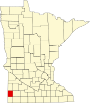
Pipestone County is a county in the U.S. state of Minnesota. As of the 2020 census, the population was 9,424. Its county seat is Pipestone.

<span class="mw-page-title-main">Trommald, Minnesota</span> City in Minnesota, United States

Trommald is a city in Crow Wing County, Minnesota, United States. The population was 99 at the 2020 census. It is part of the Brainerd Micropolitan Statistical Area.

<span class="mw-page-title-main">Sunburg, Minnesota</span> City in Minnesota, United States

Sunburg is a city in Kandiyohi County, Minnesota, United States. The population was 94 at the 2020 census.

<span class="mw-page-title-main">Avoca, Minnesota</span> City in Minnesota, United States

Avoca is a city in Murray County, Minnesota, United States. The population was 111 at the 2020 census.

<span class="mw-page-title-main">Hadley, Minnesota</span> City in Minnesota, United States

Hadley is a city in Murray County, Minnesota, United States. The population was 54 at the 2020 census.

<span class="mw-page-title-main">Slayton, Minnesota</span> City in Minnesota, United States

Slayton is a city in and the county seat of Murray County, Minnesota, United States. The population was 2,013 at the 2020 census.

<span class="mw-page-title-main">Erhard, Minnesota</span> City in Minnesota, United States

Erhard is a city in Otter Tail County, Minnesota, United States. The population was 132 at the 2020 census.

<span class="mw-page-title-main">Urbank, Minnesota</span> City in Minnesota, United States

Urbank is a city in Otter Tail County, Minnesota, United States. The population was 52 at the 2020 census.

<span class="mw-page-title-main">Hatfield, Minnesota</span> City in Minnesota, United States

Hatfield is a city in Pipestone County, Minnesota, United States. The population was 54 at the 2010 census.

<span class="mw-page-title-main">Holland, Minnesota</span> City in Minnesota, United States

Holland is a city located along the Rock River in Pipestone County in the U.S. state of Minnesota. Located in Pipestone County, it lies approximately eight miles from the city of Pipestone. The population was 187 at the 2010 census, and 215 in 2000.

<span class="mw-page-title-main">Ihlen, Minnesota</span> City in Minnesota, United States

Ihlen is a city in Pipestone County, Minnesota, United States. The population was 61 at the 2020 census.

<span class="mw-page-title-main">Pipestone, Minnesota</span> City in Minnesota, United States

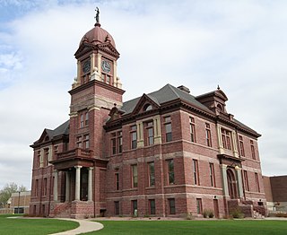
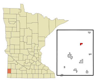
Pipestone is a city and the county seat of Pipestone County, Minnesota. The population was 4,215 at the 2020 census. The city is also the site of the Pipestone National Monument.

<span class="mw-page-title-main">Ruthton, Minnesota</span> City in Minnesota, United States

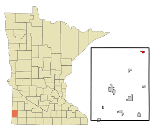
Ruthton is a city in Pipestone County, Minnesota, United States. The population was 241 at the 2010 census.

Sweet Township is a township in Pipestone County, Minnesota, United States. The population was 448 at the 2000 census. The unincorporated community of Airlie is located here, one mile east of the South Dakota border. The Pipestone National Monument is also located here. The township lies just outside the city of Pipestone, adjacent to the city's western and southwestern sides.

<span class="mw-page-title-main">Trosky, Minnesota</span> City in Minnesota, United States

Trosky is a city in Pipestone County, Minnesota, United States. The population was 98 at the 2020 census.

<span class="mw-page-title-main">McKinley, St. Louis County, Minnesota</span> City in Minnesota, United States

McKinley is a city in Saint Louis County, Minnesota, United States; located within the Iron Range region of Minnesota. The population was 103 at the 2020 census.

<span class="mw-page-title-main">St. Rosa, Minnesota</span> City in Minnesota, United States

Saint Rosa is a city in Stearns County, Minnesota, United States. The population was 58 at the 2020 census. It is part of the St. Cloud Metropolitan Statistical Area.

<span class="mw-page-title-main">Lake Wilson, Minnesota</span> City in Minnesota, United States

Lake Wilson is a city in Murray County, Minnesota, United States. The population was 254 at the 2020 census.

<span class="mw-page-title-main">Jasper, Minnesota</span> City in Minnesota, United States

Jasper is a city in Pipestone and Rock counties in the State of Minnesota. The population was 633 at the 2010 census. Most of the city lies in Pipestone County, with only a small part of the city extending into Rock County.

<span class="mw-page-title-main">Minneiska, Minnesota</span> City in Minnesota, United States

Minneiska is a city in Wabasha and Winona counties in the U.S. state of Minnesota. The population was 97 at the 2020 census.

References

  1. 1 2 "2023 U.S. Gazetteer Files". United States Census Bureau. Retrieved February 28, 2024.
  2. 1 2 U.S. Geological Survey Geographic Names Information System: Woodstock, Minnesota
  3. 1 2 3 "Explore Census Data". United States Census Bureau . Retrieved February 28, 2024.
  4. 1 2 "City and Town Population Totals: 2020–2022". United States Census Bureau. February 28, 2024. Retrieved February 28, 2024.
  5. "Woodstock (MN) sales tax rate" . Retrieved February 28, 2024.
  6. 1 2 Upham, Warren (1920). Minnesota Geographic Names: Their Origin and Historic Significance. Minnesota Historical Society. p.  https://archive.org/details/minnesotageogra00uphagoog/page/n438 419].
  7. Chicago and North Western Railway Company (1908). A History of the Origin of the Place Names Connected with the Chicago & North Western and Chicago, St. Paul, Minneapolis & Omaha Railways. p. 197.
  8. "Pipestone County". Jim Forte Postal History. Retrieved July 31, 2015.
  9. "Census of Population and Housing". United States Census Bureau. Retrieved June 4, 2015.