Burke Township, Pipestone County, Minnesota

Last updated

Burke Township, Minnesota
USA Minnesota location map.svg
Red pog.svg
Burke Township, Minnesota
Location within the state of Minnesota
Usa edcp location map.svg
Red pog.svg
Burke Township, Minnesota
Burke Township, Minnesota (the United States)
Coordinates: 43°59′5″N96°8′3″W / 43.98472°N 96.13417°W / 43.98472; -96.13417
Country United States
State Minnesota
County Pipestone
Area
  Total34.6 sq mi (89.5 km2)
  Land34.6 sq mi (89.5 km2)
  Water0.0 sq mi (0.0 km2)
Elevation
1,693 ft (516 m)
Population
 (2000)
  Total246
  Density7.1/sq mi (2.7/km2)
Time zone UTC-6 (Central (CST))
  Summer (DST) UTC-5 (CDT)
FIPS code 27-08650 [1]
GNIS feature ID0663704 [2]

Burke Township is a township in Pipestone County, Minnesota, United States. The population was 246 at the 2000 census.

Contents

History

Burke Township was organized in 1879, and named for Thomas Nicholas Burke (1830–1882), an Irish Roman Catholic theologian and preacher. [3]

Geography

According to the United States Census Bureau, the township has a total area of 34.6 square miles (90 km2), all land.

Demographics

As of the census [1] of 2000, there were 246 people, 85 households, and 74 families residing in the township. The population density was 7.1 inhabitants per square mile (2.7/km2). There were 88 housing units at an average density of 2.5 per square mile (0.97/km2). The racial makeup of the township was 97.56% White, 1.63% Asian, and 0.81% from two or more races.

There were 85 households, out of which 41.2% had children under the age of 18 living with them, 83.5% were married couples living together, 2.4% had a female householder with no husband present, and 11.8% were non-families. 11.8% of all households were made up of individuals, and 4.7% had someone living alone who was 65 years of age or older. The average household size was 2.89 and the average family size was 3.12.

In the township the population was spread out, with 28.5% under the age of 18, 8.1% from 18 to 24, 23.2% from 25 to 44, 29.3% from 45 to 64, and 11.0% who were 65 years of age or older. The median age was 38 years. For every 100 females, there were 98.4 males. For every 100 females age 18 and over, there were 100.0 males.

The median income for a household in the township was $35,903, and the median income for a family was $36,167. Males had a median income of $26,563 versus $17,500 for females. The per capita income for the township was $12,992. About 18.4% of families and 14.0% of the population were below the poverty line, including 11.1% of those under the age of eighteen and none of those 65 or over.

Politics

Burke Township is located in Minnesota's 1st congressional district, represented by Mankato educator Tim Walz, a Democrat. At the state level, Burke Township is located in Senate District 22, represented by Republican Doug Magnus, and in House District 22A, represented by Republican Joe Schomacker.

In the 2020 Democratic Party presidential primaries, it was the only township in the state to vote for candidate Tulsi Gabbard. [4]

Related Research Articles

Richwood Township is a township in Becker County, Minnesota, United States. The population was 610 as of the 2000 census.

Alliance Township is a township in Clay County, Minnesota, United States. The population was 246 at the 2000 census.

Bay Lake Township is a township in Crow Wing County, Minnesota, United States. The population was 923 at the 2000 census. This township took its name from Bay Lake.

Garrison Township is a township in Crow Wing County, Minnesota, United States. The population was 796 at the 2000 census. Within the township is the city of Garrison.

Sibley Township is a former township in Crow Wing County, Minnesota, United States. The population was 855 at the 2000 census. On June 4, 2002, the entire township was annexed to the neighboring city of Pequot Lakes, thus rendering the township government defunct.

Milton Township is a township in Dodge County, Minnesota, United States. The population was 692 at the 2000 census.

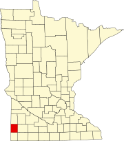
Verona Township is a township in Faribault County, Minnesota, United States. The population was 391 at the 2000 census.

Arbo Township is a township in Itasca County, Minnesota, United States. The population was 867 at the 2010 census.

Bowstring Township is a township in Itasca County, Minnesota, United States. The population was 230 at the 2010 census.

Deer River Township is a township in Itasca County, Minnesota, United States. The population was 704 at the 2010 census.

Oteneagen Township is a township in Itasca County, Minnesota, United States. The population was 310 at the 2010 census.

South Fork Township is a township in Kanabec County, Minnesota, United States. The population was 662 at the 2000 census.

Dailey Township is a township in Mille Lacs County, Minnesota, United States. The population was 234 at the 2010 census.

Corliss Township is a township in Otter Tail County, Minnesota, United States. The population was 462 at the 2000 census.

Effington Township is a township in Otter Tail County, Minnesota, United States. The population was 297 at the 2000 census.

<span class="mw-page-title-main">Bremen Township, Pine County, Minnesota</span> Township in Minnesota, United States

Bremen Township is a township in Pine County, Minnesota, United States. The population was 246 at the 2000 census.

Hubbard Township is a township in Polk County, Minnesota, United States. It is part of the Grand Forks-ND-MN Metropolitan Statistical Area. The population was 83 at the 2000 census.

Lake Henry Township is a township in Stearns County, Minnesota, United States. The population was 278 at the 2010 census.

Fieldon Township is a township in Watonwan County, Minnesota, United States. The population was 246 at the 2000 census.

<span class="mw-page-title-main">Ararat Township, Susquehanna County, Pennsylvania</span> Township in Pennsylvania, United States

Ararat Township is a township in Susquehanna County, Pennsylvania, United States. The population was 526 at the 2020 census.

References

  1. 1 2 "U.S. Census website". United States Census Bureau . Retrieved January 31, 2008.
  2. "US Board on Geographic Names". United States Geological Survey. October 25, 2007. Retrieved January 31, 2008.
  3. Upham, Warren (1920). Minnesota Geographic Names: Their Origin and Historic Significance. Minnesota Historical Society. p.  417.
  4. "Results: The Most Detailed Map of the Minnesota Democratic Primary". www.nytimes.com. The New York Times. Retrieved August 14, 2023.