Related Research Articles

Amador County, is a county in the U.S. state of California, in the Sierra Nevada. As of the 2010 census, the population was 38,091. The county seat is Jackson. Amador County, located within California's Gold Country, is known as "The Heart of the Mother Lode". There is a substantial viticultural industry in the county.

Amador City is a city in Amador County, California, United States. The population was 185 at the 2010 census, down from 196 at the 2000 census. Amador City is noted for being the smallest city in California by size.
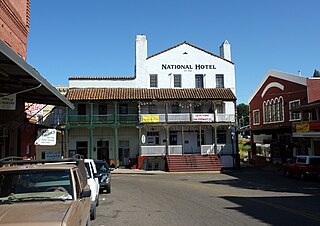
Jackson is a city in and the county seat of Amador County, California. The population was 4,651 at the 2010 census, up from 3,989 at the 2000 census. The city is accessible by both State Route 49 and State Route 88.

Sutter Creek is a city in Amador County, California, United States. The population was 2,501 at the 2010 census, up from 2,303 at the 2000 census. It is accessible via State Route 49.

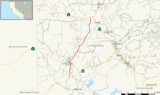
State Route 49 is a north–south state highway in the U.S. state of California that passes through many historic mining communities of the 1849 California gold rush. Highway 49 is numbered after the "49ers", the waves of immigrants who swept into the area looking for gold, and it is known as the Golden Chain Highway. This roadway begins at Oakhurst, Madera County, in the Sierra Nevada, where it diverges from State Route 41. It continues in a generally northwest direction, weaving through the communities of Goldside and Ahwahnee, before crossing into Mariposa County. State Route 49 then continues northward through the counties of Tuolumne, Calaveras, Amador, El Dorado, Placer, Nevada, Yuba, Sierra, and Plumas, where it reaches its northern terminus at State Route 70, in Vinton.
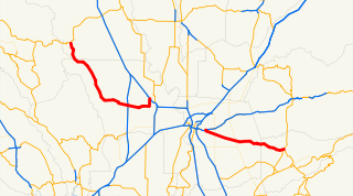
State Route 16 is a state highway in the northern region of the U.S. state of California that runs from Route 20 in Colusa County to Route 49 just outside Plymouth in Amador County, primarily crossing the Sacramento Valley. Much of the route through the Sacramento area is unsigned as it runs on a concurrency with the I-5 and US 50 freeways.
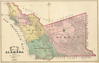
Murray Township was a township located in what is now the Livermore Valley portion of Alameda County, California, including the present day cities of Livermore, Dublin, and Pleasanton, and the census-designated place of Sunol.
State Route 124 is a state highway in the U.S. state of California that runs in Amador County from State Route 88 south of Ione to State Route 16 near Waits Station.
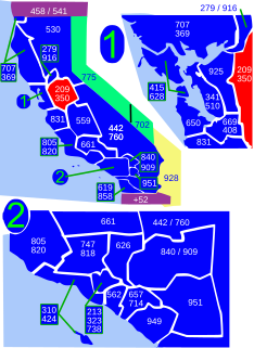
Area code 209 is the California telephone area code that was split from area code 415 on October 26, 1957. It covers Stockton, Modesto, Turlock, Merced, Winton, Atwater, Livingston, Manteca, Ripon, Tracy, Lodi, Galt, Sonora, Los Banos, San Andreas, Mariposa, and Yosemite, the northern San Joaquin Valley, and the Sierra Foothills.

The Amador Central Railroad was a standard gauge railroad that operated 11.8 miles (19.0 km) between a connection with the Southern Pacific Company (SP) at Ione and Martell near the town of Jackson, California. The carrier served the Sierra Nevada Foothills gold mining communities and hauled lumber products from the El Dorado National Forest. Amador is the name of the county in which the railroad operated.
Amador High School, located in Sutter Creek, California, is one of two high schools in Amador County. It is a public school that serves about 700 students in grades 9-12. Originally known as "Amador County High School" at its inception in 1911, the school's name changed to "Sutter Creek Union High School" in 1916, reverting to "Amador County High School" in 1949, at the request of that year's graduating class. In 1984, upon completion of the merger of three school districts in the county, the name was changed to "Amador High School".

Enterprise is a former mining camp in Amador County, California. It is located 5.5 miles (8.9 km) west-northwest of Fiddletown, on Big Indian Creek, at an elevation of 876 feet. Established to mine quartz, at its peak it had a population of around a hundred, but the prospects did not pan out, and there are only a few houses in the area now.
Secreta is a former settlement and mining camp in Amador County, California. It was on the South Fork Jackson Creek downstream from Clinton.
Mahala Flat is a former settlement in Amador County, California. It was located on the South Branch of Sutter Creek, south-southeast of Volcano.
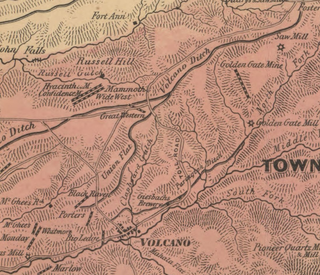
Fort Ann is a former gold mining camp in Amador County, California. It was located on the South Fork of Dry Creek, 3.5 miles (5.6 km) north of Volcano. Although local tradition has it that Fort Ann began as a military outpost, it began as a mining camp.
Copper Hill is a former settlement in Amador County, California. It was located between Little Indian Creek and the Cosumnes River, 3.5 miles (5.6 km) north-northwest of Forest Home.
Chaparral Hill is a former and mining camp in Amador County, California.
Amador Valley is a valley in eastern Alameda County, California and is the location of the cities of Dublin and Pleasanton. The valley is bounded by the foothills of the Diablo Range on the north and south, Pleasanton Ridge to the west, and Livermore Valley to the east.

Lake Amador is a reservoir located in Amador County, California. It lies at an elevation of 325 feet.

José María Amador was a Californio ranchero, gold miner, and soldier. Amador County and Amador City are both named after Amador, having found gold there in 1848.
References
- ↑ Durham, David L. (1998). California's Geographic Names: A Gazetteer of Historic and Modern Names of the State. Clovis, Calif.: Word Dancer Press. p. 442. ISBN 1-884995-14-4.
Municipalities and communities of Amador County, California, United States | ||
|---|---|---|
| Cities |  | |
| CDPs | ||
| Unincorporated communities | ||
| Ghost towns |
| |
| Footnotes | ‡This CDP also has portions in an adjacent county or counties | |
| This Amador County, California-related article is a stub. You can help Wikipedia by expanding it. |