Amper

Last updated • 9 min readFrom Wikipedia, The Free Encyclopedia

Amper
Amper I.jpg
The Amper south of Fürstenfeldbruck
Flusssystem Ammer Amper.png
The Ammer/Amper system within the Isar basin
Location
CountryGermany
State Bavaria
Physical characteristics
Source 
  location Northern Limestone Alps
Mouth  
  location
Isar
  coordinates
48°30′1″N11°57′24″E / 48.50028°N 11.95667°E / 48.50028; 11.95667
Length190 km (120 mi)
Basin size3,248 km2 (1,254 sq mi) [1]
Discharge 
  average±45 m3/s (1,600 cu ft/s)
Basin features
Progression IsarDanubeBlack Sea

The Amper, called the Ammer upstream of the Ammersee, through which it runs, is the largest tributary of the Isar in southern Bavaria, Germany. It flows generally north-eastward, reaching the Isar in Moosburg, about 185 kilometres (115 mi) from its source in the Ammergau Alps, with a flow of 45 m³/s. Including its tributary, Linder, it is 209.5 km (130.2 mi) long. [1] Major tributaries are the Glonn, which rises near Augsburg; the Würm, which is the outflow of Lake Starnberg; and the Maisach.

Contents

Etymology

The term "Amper" can be derived from the Indo-European root * ombh-," which denotes water or a watercourse. The Celtic name "ambra" was adopted by the Romans and has been attested as genitive ambre and locative amber since the 3rd century. According to another interpretation, Amper is related to the Breton and therefore Celtic word ampart. Accordingly, the river name would stand for the terms skillful, agile and strong.

In 1243 the Ammersee was first referred to as the Amirsee and it was not until the 14th century that a distinction was made between the Ammer as a tributary to the Ammersee and the Amper.

Geography

The Ammer, and thus also the Amper, drains part of the Ammergau Mountains to the northeast to the Isar and thus to the Danube. Over a distance of around 100 km, the Amper crosses four natural areas: the steep old and young moraines, the flat gravel plain and the Danube-Isar hill country.

The Ammer/Amper river system overcomes a total of 430 metres (1,410 ft) in altitude. The Ammer loses almost 200 meters in the 20-kilometer-long gorge south of Peißenberg.

Source

The source area of the Ammer is located in the Ammergau Alps at the exit of the Graswang valley between Graswang and Ettal. Some of the water flows down from a raised bog, and some of the various spring pots in the valley floor are fed by the water of the Linder that emerges here on the border between Tyrol and Bavaria near the Ammersattel.

The streams are fed by the Großer Ammerquellen, located on both sides of the river bed of the Linder, flow into the mostly dry bed of the Linder and, at some times of the year, together with the Linder, which is still flowing here, form the Große Ammer. The Kleine Ammer springs, located on the north side of the Graswang Valley, feed the Kleine Ammer, which flows into the Große Ammer between Ettal and Oberammergau and forms the Ammer with it.

Ammer

The Ammersee with the Alps in the background Ammersee und Alpen.jpg
The Ammersee with the Alps in the background

North of Unterammergau, the river leaves the Bavarian Alps after about 15 kilometers and flows through the Ammer-Loisach hill country to the north. In this young moraine landscape, created from the deposits of the Isar-Loisach glacier during the Würm glacial period, the Ammer cuts up to 80 meters deep into the moraine and the molasse underneath and forms the Ammerschlucht, also called Ammerleite. To the south of Hohenpeißenberg, the Ammer Gorge bends to the east. At Peißenberg, the river leaves the gorge and turns back north. It flows through a long, wide valley until it flows into the Ammersee east of Dießen am Ammersee. A little before that, the Alte Ammer branches off to the left, which after a short run is absorbed by the longer but usually less watery Rott, which also flows into the Ammersee.

Amper

After exiting the Ammersee near Eching am Ammersee, the Amper valley first cuts through a terminal moraine landscape of the Isar-Loisach glacier from the Würm glacial period near Grafrath and then flows through the Munich gravel plain from Fürstenfeldbruck. To the northeast of Dachau it comes into the area of the tertiary Danube-Isar hill country and finally flows into the Isar at Moosburg. Southwest of Moosburg, most of its water (30 m³/s) is withdrawn from the Amper and fed to the Isar through a canal south of Moosburg. This water is used to generate energy in the Uppenborn works on the Mittlere-Isar canal through another connecting canal. Immediately before it flows into the Isar, another part of the water is branched off and flows as the Klötzlmühlbach north of the Isar to Landshut.

Tributaries

The first tributary of the Ammer is shortly after the connection of the outflows from the Große Ammerquellen with the Linder is the approximately 7 kilometers long near Kohlbach. Its longest tributary in the Ammergau Alps is the Halbammer, which flows into it from the left at Saulgrub. In the area of the Ammer Gorge, the Ammer only takes in smaller streams. After exiting the gorge, the 19-kilometer-long Eyach and the 43-kilometer long Ach, which forms the outflow of the Staffelsee and is the longest tributary of the Ammer before it flows into the Ammersee, flow into it from the right in quick succession near Oberhausen. Larger tributaries in the further course to the Ammersee are the Angerbach near Weilheim in Upper Bavaria, the Grünbach near Wielenbach and the Kinschbach near Pähl, all of which flow into them from the right.

Larger tributaries of the Ammersee are the Rott near Dießen am Ammersee and the Kienbach and Fischbach in Herrsching am Ammersee.

Shortly after leaving the Ammersee, the Amper near Eching am Ammersee takes up the 36-kilometer-long Windach from the left. Other major tributaries are the Maisach (36 km long, flows from the left at Günding), the Würm, which forms the outflow of Lake Starnberg (40 km long, flows from the right at Hebertshausen) and the Glonn, which is 50 kilometers long the longest Amper tributary is (flows from the left at Allershausen). Shortly before the confluence of the Amper into the Isar, the approximately 14-kilometer-long Mühlbach, which is derived from the Moosach, flows into it at Wang as its last tributary from the right.

Nature and environmental protection

Since the middle of the 19th century, the natural course of the Ammer and Amper has been significantly changed by flood protection and the construction of power plants – with far-reaching consequences for the native flora and fauna. The continuity of the flowing water is often disturbed by weirs. This makes the migration and distribution of fish upstream and downstream more difficult or even impossible. The dike in some areas also meant an interference with the ecological balance. The alluvial forests were shielded from the natural water inflow by the dikes, so that the alluvial forest is only in remnants. To preserve the original river landscape, at least in some areas, several nature reserves, such as the Amperauen nature reserve with Leitenwälder between Fürstenfeldbruck and Schöngeising, have been designated.

The Ammer estuary and the Ampermoos nature reserve north of the Ammersee are among the seven internationally significant wetlands in Bavaria.

Business

Shipping

The Amper is only navigable in part and has no significance for inland navigation.

From 1880 to 1939 a regular steamboat connection operated between Stegen am Ammersee and Grafrath, which was mainly used by excursionists from Munich. These took the train to Grafrath and walked about 1.5 km from the train station to the landing stage. There they boarded the boat to Stegen, where they could transfer to Ammersee steamships.

After the opening of the railway line between Munich and Herrsching, the number of passengers on the water sank so much that the costs of keeping the section navigable made operation uneconomical; the ship connection from Grafrath to Stegen had to be stopped. The beginning of the Second World War brought the end to shipping on the Amper. The Maria Therese was the first steamship that opened the Amper shipping line between Inning and Grafrath on 10 May 1880. It was popularly known as the "Mooskuh" because the entire route between Grafrath and the Ammersee ran through the Ampermoos and its beep resembled the call of the bittern.

In the past, wood was rafted on the river, mainly from the Ammer Mountains. This is indicated by names such as Trifthof for an industrial park in Weilheim. This Trifthof was built in 1611. To bring the tree trunks further across the Ammersee to Dachau, they were connected to form drift rafts.

Power generation

Share of the Amperwerke Elektricitats-AG, issued 27 September 1932 Amperwerke Elektricitats-AG 1932.jpg
Share of the Amperwerke Elektricitäts-AG, issued 27 September 1932

Two hydropower plants are of historical importance. As early as 1891/92, the first hydropower plant in Bavaria was built by Oskar von Miller in Schöngeising. The world's first rail power station for single-phase alternating current, the Kammerl power station, went into operation a few years later around 1898 west of Saulgrub in the Ammertal valley. It served to supply the 23-kilometer-long line between Murnau and Oberammergau belonging to the Lokalbahn Aktien-Gesellschaft, which started the first scheduled electric train service in 1905. The Amperwerke was founded in 1908 to systematically use the hydropower on the Amper. A number of other run-of-river power plants along the river system with regional economic importance emerged in this way, mostly up to the First World War. These are works, among others. in Unterbruck near Fürstenfeldbruck (1892), Olching, Dachau, Hebertshausen, Volkmannsdorf near Allershausen or Kranzberg (1911). Hydropower plants require a consistently high water level so that energy generation does not come to a standstill in months with little rainfall. This was ensured by building a few smaller canals, weirs and a storage reservoir near Fürstenfeldbruck. At Zolling, Amper supplies the Zolling power plant with cooling water via a canal. The Haag hydropower plant is located on the same canal.

Tourism

In addition to a number of interesting cities along the Ammer and Amper rivers such as Weilheim, Fürstenfeldbruck, Dachau and Moosburg, the Ammersee in particular is of touristic importance. Along the Ammer, the Schleier waterfalls south of Bad Bayersoien and the Echelsbacher Bridge are the most important sights.

Long stretches of the river are lined with cycle paths that allow tours from the Alps to the mouth of the Amper at Moosburg an der Isar. Driving on the Ammer and Amper with canoes or similarly manoeuvrable boats is possible over almost the entire route, but not allowed all year round. Boating on the Ammer between 1 December and 30 April is only allowed with a discharge of at least 6 cubic meters / second. [2] During the bird breeding season (1 March to 15 July), driving on the Amper from Stegen to Grafrath and between Schöngeising and Fürstenfeldbruck is prohibited. [3] The city of Fürstenfeldbruck has designated a number of official bathing opportunities along the Amper.

See also

Literature

Related Research Articles

<span class="mw-page-title-main">Dachau, Bavaria</span> Town in Bavaria, Germany

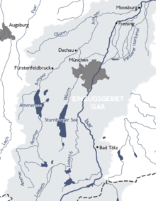
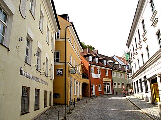
Dachau is a town in the Upper Bavaria district of Bavaria, a state in the southern part of Germany. It is a major district town—a Große Kreisstadt—of the administrative region of Upper Bavaria, about 20 kilometres north-west of Munich. It is now a popular residential area for people working in Munich, with roughly 45,000 inhabitants. The historic centre of town with its 18th-century castle is situated on an elevation and visible over a great distance.

<span class="mw-page-title-main">Isar</span> River in Austria and Germany

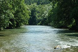
The Isar is a river in Austria and in Bavaria, Germany. Its source is in the Karwendel mountain range of the Alps. The Isar river enters Germany near Mittenwald and flows through Bad Tölz, Munich, and Landshut before reaching the Danube near Deggendorf. With 295 km length, it is among the longest rivers in Bavaria. It is Germany's second most important tributary of the Danube.

Munich is a Landkreis (district) in Bavaria, Germany. It borders the districts of Dachau, Freising, Erding, Ebersberg, Rosenheim, Miesbach, Bad Tölz-Wolfratshausen, Starnberg, Fürstenfeldbruck, and almost encircles the district-free city of Munich itself, which is the district seat.

<span class="mw-page-title-main">Ammersee</span> Lake in Upper Bavaria, Germany

Ammersee is a Zungenbecken lake in Upper Bavaria, Germany, southwest of Munich between the towns of Herrsching and Dießen am Ammersee. With a surface area of approximately 47 square kilometres (18 sq mi), it is the sixth largest lake in Germany. The lake is at an elevation of 533 metres (1,749 ft), and has a maximum depth of 81 metres (266 ft). Like other Bavarian lakes, Ammersee developed as a result of the ice age glaciers melting. Ammersee is fed by the River Ammer, which flows as the Amper out of the lake. Like neighbouring Lake Starnberg - deeper, bigger in surface area, similar in shape - it is a popular location for watersports.

<span class="mw-page-title-main">Loisach</span> River in Germany

The Loisach is a river that flows through Tyrol, Austria and Bavaria, Germany. The Loisach runs through the great moors Murnauer Moos and Loisach-Kochelsee-Moore

<span class="mw-page-title-main">Lake Starnberg</span> Lake in Bavaria, Germany

Lake Starnberg, or Starnberger See ) — called Lake Würm or Würmsee until 1962 — is Germany's second-largest body of fresh water, having great depth, and fifth-largest lake by area. It and its surroundings lie in three different Bavarian districts, or Landkreise. The lake is property of the state and accordingly managed by the Bavarian Administration of State-Owned Palaces, Gardens and Lakes.

<span class="mw-page-title-main">Würm</span> River in Germany

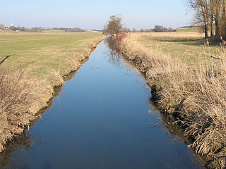
The Würm is a river in Bavaria, Germany, right tributary of the Amper. The length of the river is 39.8 kilometres (24.7 mi), or 76.3 kilometres (47.4 mi) including the Steinbach, the main feed of Lake Starnberg. It drains the overflow from Lake Starnberg and flows swiftly through the villages of Gauting, Krailling, Planegg, Gräfelfing and Lochham as well as part of Munich before joining, near Dachau, the Amper, which soon afterwards flows into the Isar and eventually into the Danube. Although the Würm is not a very large river, it is well known as it gave its name to the Würm glaciation.

<span class="mw-page-title-main">Ammer Saddle</span>

The Ammer Saddle is a high mountain pass in the Alps on the border between Tyrol, Austria and Bavaria, Germany.

<span class="mw-page-title-main">Wutach (river)</span> River in Germany

The Wutach is a river, 91 kilometres long, in the southeastern part of the Black Forest in the German state of Baden-Württemberg. It is a right-hand tributary of the Rhine. In its lower reaches it flows for about 6 kilometres along the border with the canton of Schaffhausen, Switzerland.

The 1999 Pentecost flood was a 100-year flood around the Pentecost season in 1999 that mostly affected Bavaria, Vorarlberg and Tirol. It was caused by heavy rainfall coinciding with the regular Alpine meltwater.

<span class="mw-page-title-main">Sylvenstein Dam</span> Dam in Bad Tölz-Wolfratshausen

Sylvenstein Dam is an earthen embankment dam in the Isar valley, in the alpine part of Upper Bavaria, Germany which impounds the Sylvenstein Reservoir.

<span class="mw-page-title-main">Ammergau Alps</span> Mountain range in the states of Bavaria, Germany and Tyrol, Austria

The Ammergau Alps are a mountain range in the Northern Limestone Alps in the states of Bavaria (Germany) and Tyrol (Austria). They cover an area of about 30 x 30 km and begin at the outer edge of the Alps. The highest summit is the Daniel which has a height of 2,340 metres (7,680 ft).

<span class="mw-page-title-main">Glonn (Amper)</span> River in Bavaria, Germany

The Glonn is a river of Upper Bavaria, Bavaria, Germany.

<span class="mw-page-title-main">Moosach (river)</span> River near Munich in Bavaria, Germany

Moosach is a 38-kilometre-long (24 mi) left tributary of the river Isar near Munich in Bavaria, Germany. It could also be described as a tributary of the river Amper, because of the stream Mühlbach that splits away carrying about 30% of the water just before the Moosach joins the Isar. After passing through Freising, the main flow enters the Isar near Oberhummel. The Mühlbach branch continues through Moosburg and enters the Amper close to its confluence with the Isar.

An alpentor in geology is the point where an entire glacier forced its way through to the Alpine Foreland from the Alps during the ice age.

<span class="mw-page-title-main">Austria–Germany border</span> International border

The border between the modern states of Austria and Germany has a length of 815.9 km (507.0 mi), or 815.0 km (506.4 mi) respectively. It is the longest international border of Austria and the second longest border of Germany with another country.

<span class="mw-page-title-main">Munich–Buchloe railway</span> Railway line in Bavaria, Germany

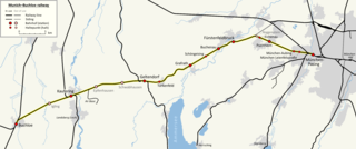
The Munich–Buchloe railway is a double-track, electrified main line in Bavaria, Germany. The 60 kilometre-long line runs from Munich Pasing via Geltendorf and Kaufering to Buchloe. Together with the Buchloe–Kempten–Lindau line, it is known as the Allgäubahn. The line is owned and maintained by DB Netz.

References

  1. 1 2 Complete table of the Bavarian Waterbody Register by the Bavarian State Office for the Environment (xls, 10.3 MB)
  2. "Wasserstand am Pegel Peissenberg/ Ammer bei 4-paddlers.com". 4-paddlers.com. Retrieved 21 October 2021.
  3. "Info page of the Fürstenfeldbruck district office" (PDF). Archived (PDF) from the original on 24 May 2014. Retrieved 20 October 2021.