
Ancroft is a village and civil parish in Northumberland, England. Prior to 1844, Ancroft lay within the Islandshire exclave of County Durham. It is south of Berwick-upon-Tweed, and has a population of 885, rising slightly to 895 at the 2011 census.

Islandshire was an area of Northumberland, England, comprising Lindisfarne or Holy Island, plus five parishes on the mainland.
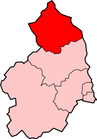
Berwick-upon-Tweed was a local government district and borough in Northumberland in the north-east of England, on the border with Scotland. The district had a resident population of 25,949 according to the 2001 census, which also notes that it is the most ethnically homogeneous in the country, with 99.6% of the population recording themselves in the 2001 census as White. It was also the smallest district in England with borough status, and the third-least densely populated local government district.

Dulverton is a small town and civil parish in the heart of West Somerset, England, near the border with Devon. The town has a population of 1,408. The parish includes the hamlets of Battleton and Ashwick which is located approximately 3.5 miles (5.6 km) north west of Dulverton. To the west of the hamlet lies Ashwick House, built in the Edwardian style in 1901. Also nearby is the estate of Northmoor, formerly a seat of Sir Frederick Wills,1st Baronet of Northmoor, one of the four Wills Baronetcys, and the founders of the Imperial Tobacco Company. In 1929 Sir Frederick's son & heir, Sir Gilbert Wills, 2nd Baronet, was raised to the peerage as Baron Dulverton, whose principal seat was at Batsford Park, near Batsford, Gloucestershire.

In England, a civil parish is a type of administrative parish used for local government. It is a territorial designation which is the lowest tier of local government below districts and counties, or their combined form, the unitary authority. Civil parishes can trace their origin to the ancient system of ecclesiastical parishes which historically played a role in both civil and ecclesiastical administration; civil and religious parishes were formally split into two types in the 19th century and are now entirely separate. The unit was devised and rolled out across England in the 1860s.

The Llŷn Peninsula extends 30 miles (50 km) into the Irish Sea from north west Wales, south west of the Isle of Anglesey. It is part of the historic county of Caernarfonshire, and historic region and local authority area of Gwynedd. Much of the eastern part of the peninsula, around Criccieth, may be regarded as part of Eifionydd rather than Llŷn, although the boundary is somewhat vague. The area of Llŷn is about 400 km2, and its population is at least 20,000.

The Counties Act 1844, which came into effect on 20 October 1844, was an Act of Parliament of the United Kingdom which eliminated many outliers or exclaves of counties in England and Wales for civil purposes.

Northmoor Green is a village in south central Somerset, England, that is more commonly known as Moorland, and sometimes mistakenly called Fordgate even though it is a separate hamlet. These places being hamlets of Moorland in the civil parish of North Petherton.

Little Wittenham is a village and civil parish on the south bank of the River Thames, northeast of Didcot in South Oxfordshire. In 1974 it was transferred from Berkshire to the county of Oxfordshire and from Wallingford Rural District to the district of South Oxfordshire.
Long Wittenham is a village and small civil parish about 3 miles (5 km) north of Didcot, and 3.5 miles (5.6 km) southeast of Abingdon. It was part of Berkshire until the 1974 boundary changes transferred it from Berkshire to Oxfordshire, and from the former Wallingford Rural District to the new district of South Oxfordshire.
Northmoor is a village and civil parish in West Oxfordshire, about 6 miles (10 km) west of Oxford and almost the same distance southeast of Witney. Northmoor is in the valley of the River Thames, which bounds the parish to the east and south, and is close to the River Windrush which forms part of the parish's western boundary. The 2011 Census recorded the parish's population as 377.

Hassall is a village and civil parish in the Borough of Cheshire East and the ceremonial county of Cheshire, England. The civil parish contains the very small hamlet of Day Green. According to the 2001 Official UK Census, the population was 281, reducing to 265 at the 2011 Census.

Hampton is a former civil parish, now in the parishes of No Man's Heath and District and Malpas, in the unitary authority of Cheshire West and Chester and the ceremonial county of Cheshire, England. According to the 2001 UK census, the total population of the civil parish was 409, decreasing marginally to 405 at the 2011 Census. The parish included Hampton Green. The civil parish was abolished in 2015 to form No Man's Heath and District, part of it also went to Malpas.

Taynton is a village and civil parish about 1 1⁄2 miles (2.4 km) northwest of Burford in West Oxfordshire. The village is on Coombe Brook, a tributary of the River Windrush. The parish is bounded in the south by the River Windrush, in the north partly by Coombe Brook and its tributary Hazelden Brook, in the west by the county boundary with Gloucestershire and in the east by field boundaries. The 2001 Census recorded the parish's population as 108.

Tiverton is a village and former civil parish, now in the parishes of Tiverton and Tilstone Fearnall and Tarporley, in the Cheshire West and Chester district and ceremonial county of Cheshire in England. It had a population of 406 in 2001, reducing to 318 at the 2011 census. The civil parish was abolished in 2015 to form Tiverton and Tilstone Fearnall, part also went to Tarporley. The former civil parish of Tiverton and the current parish of Tiverton and Tilstone Fearnall both include the hamlet of Four Lane Ends.
Stixwould and Woodhall is a civil parish in the East Lindsey district of Lincolnshire, England. The civil parish population was 255 at the 2011 census.
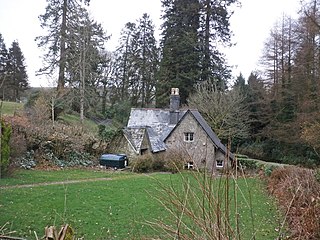
Northmoor is an historic estate in the parish of Dulverton in Somerset, England. The Victorian mansion house known as Northmoor House is set amongst steep wooded valleys on the southern edge of Exmoor.

