
Islandia is an unincorporated community and former city in Miami-Dade County, Florida, United States. It is located in the upper Florida Keys on the islands of Elliott Key and other nearby keys, such as Totten Key. It was the only municipality in the Florida Keys not located in neighboring Monroe County. The population was 18 at the 2010 Census. Most residents of the city were National Park Service employees.
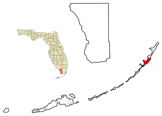
Key Largo is a census-designated place in Monroe County, Florida, United States, located on the island of Key Largo in the upper Florida Keys. The population was 10,433 at the 2010 census. The name comes from the Spanish Cayo Largo, or "long key". It is both the first island and town of the Florida Keys to be reached from the Overseas Highway to Key West. It was also the location of one of the stations of the Overseas Railroad.
North Key Largo is a census-designated place (CDP) in Monroe County, Florida, United States. The population was 1,244 at the 2010 census. It includes two private clubs, the Ocean Reef Club and the Key Largo Anglers Club and is reached from the mainland via the Card Sound Bridge.

Tavernier is a census-designated place (CDP) and unincorporated community in Monroe County, Florida, United States on Key Largo, the largest island in the upper Florida Keys. Tavernier's population was 2,173 at the 2000 census.

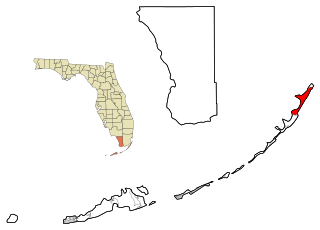
Key Largo is an island in the upper Florida Keys archipelago and is the largest section of the Keys, at 33 miles (53 km) long. It is one of the northernmost of the Florida Keys in Monroe County, and the northernmost of the Keys connected by U.S. Highway 1. Its earlier Spanish name was Cayo Largo, meaning long islet.

Elliott Key is the northernmost of the true Florida Keys, and the largest key north of Key Largo. It is located entirely within Biscayne National Park, in Miami-Dade County, Florida, east of Homestead, Florida. It is bordered by the Atlantic Ocean to the east, Biscayne Bay to the west, Sands Key to the north and Old Rhodes Key to the south. Adams Key is just west of the southern end of Elliott Key. Elliott Key is about seven miles (11 km) long. Its maximum width is about 2,500 feet (760 m) near the north end and its average width is less than 2,000 feet (610 m). The higher elevations on the island range from 6 to 8 feet (2.4 m) above sea level and occur generally along an unimproved road that runs longitudinally through the center of the island. The average elevation is about 3 feet (0.91 m) above sea level. The key is accessible only by boat. Elliott Key has a National Park Service campground, but is otherwise uninhabited.

Plantation Key is an island in Monroe County, Florida, United States. It is located in the upper Florida Keys on U.S. 1, between Key Largo and Windley Key.
Meig's Key is a small island north of the upper Florida Keys in Biscayne National Park. It is in Miami-Dade County, Florida.
Thompson is an unincorporated community in Monroe County, Florida, United States, located in the upper Florida Keys on Key Largo on US 1 northeast of Tavernier and southwest of Sunset Point and Rock Harbor.
Rock Harbor is an unincorporated community in Monroe County, Florida, United States, located in the upper Florida Keys on Key Largo on US 1 northeast of Thompson and southwest of Newport and the Census-designated place (CDP) of Key Largo.
Newport is an unincorporated community in Monroe County, Florida, United States, located in the upper Florida Keys on Key Largo on US 1 northeast of Rock Harbor and southwest of the Census-designated place (CDP) of Key Largo.
Grayvik was an unincorporated community in Monroe County, Florida, United States. It was located in the upper Florida Keys on Key Largo where the Ocean Reef Club now lies at the northnmost part of the island. It was northeast of the Census-designated place (CDP) of North Key Largo.
Sunset Point is an unincorporated community in Monroe County, Florida, United States, located in the upper Florida Keys on Key Largo on US 1 northeast of Tavernier and Thompson, and southwest of Rock Harbor.
Garden Cove is an unincorporated community in Monroe County, Florida, United States, located in the upper Florida Keys on Key Largo immediately southwest and bordering the Census-designated place (CDP) of North Key Largo.
Jewfish is an unincorporated community in Monroe County, Florida, United States. It is located in the upper Florida Keys on Key Largo off U.S. Route 1. It is just west of the census-designated place (CDP) of North Key Largo.
Carysfort is a coral reef located within the Florida Keys National Marine Sanctuary. It lies to the east of Key Largo, within the Key Largo Existing Management Area, which is immediately to the east of John Pennekamp Coral Reef State Park. This reef is within a Sanctuary Preservation Area (SPA). The reef is northeast of The Elbow.

The Elbow is a coral reef located within the Florida Keys National Marine Sanctuary. It lies to the east of Key Largo, within the Key Largo Existing Management Area, which is immediately to the east of John Pennekamp Coral Reef State Park. This reef is within a Sanctuary Preservation Area (SPA). The Elbow is southwest Carysfort and east of Dry Rocks reefs.
Dry Rocks is a coral reef located within the Florida Keys National Marine Sanctuary. It lies to the east of Key Largo, within the Key Largo Existing Management Area, which is immediately to the east of John Pennekamp Coral Reef State Park. The reef lies within a Sanctuary Preservation Area (SPA). It is close to Grecian Rocks and The Elbow.
Grecian Rocks is a coral reef located within the Florida Keys National Marine Sanctuary. It lies to the east of Key Largo, within the Key Largo Existing Management Area, which is immediately to the east of John Pennekamp Coral Reef State Park. This reef is within a Sanctuary Preservation Area (SPA).


