
Monroe County is a county in the state of Florida. As of the 2010 census, the population was 73,090. Its county seat is Key West. Monroe County includes the islands of the Florida Keys and comprises the Key West Micropolitan Statistical Area.

Islandia is an unincorporated community and former city in Miami-Dade County, Florida, United States. It is located in the upper Florida Keys on the islands of Elliott Key and other nearby keys, such as Totten Key. It was the only municipality in the Florida Keys not located in neighboring Monroe County. The population was 18 at the 2010 Census. Most residents of the city were National Park Service employees.
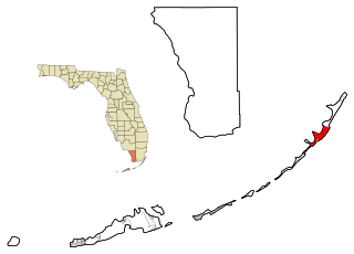
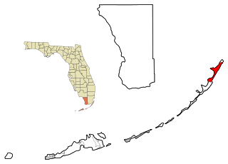
Key Largo is a census-designated place in Monroe County, Florida, United States, located on the island of Key Largo in the upper Florida Keys. The population was 10,433 at the 2010 census. The name comes from the Spanish Cayo Largo, or "long key". It is both the first island and town of the Florida Keys to be reached from the Overseas Highway to Key West. It was also the location of one of the stations of the Overseas Railroad.
North Key Largo is a census-designated place (CDP) in Monroe County, Florida, United States. The population was 1,244 at the 2010 census. It includes two private clubs, the Ocean Reef Club and the Key Largo Anglers Club and is reached from the mainland via the Card Sound Bridge.

Tavernier is a census-designated place (CDP) and unincorporated community in Monroe County, Florida, United States on Key Largo, the largest island in the upper Florida Keys. Tavernier's population was 2,173 at the 2000 census.

Card Sound Bridge is a high-rise toll causeway connecting southern Miami-Dade County and northern Monroe County. It is one of only two ways that motorists can leave or enter the Florida Keys. The toll for two-axle automobiles is USD $1.50 if paid via SunPass. An additional $2.50 surcharge is assessed for vehicles tolled via license plate photo. The all-electronic tolling system replaced the previous manned toll booth on October 20, 2018. The toll fee is waived upon evacuating the Keys for hurricanes or in instances in which US 1 is impassable.

John Pennekamp Coral Reef State Park is a Florida State Park located on Key Largo in Florida. It includes approximately 70 nautical square miles (240 km²) of adjacent Atlantic Ocean waters. The park is approximately 25 miles in length and extends 3 miles into the Atlantic Ocean. It was the first underwater park in the United States. The park was added to the National Register of Historic Places on April 14, 1972. The primary attractions of the park are the coral reefs and their associated marine life.

Plantation Key is an island in Monroe County, Florida, United States. It is located in the upper Florida Keys on U.S. 1, between Key Largo and Windley Key.

Conch Key is an island and unincorporated community in Monroe County, Florida, United States, located in the middle Florida Keys. U.S. 1 crosses the key at approximately mile markers 62-63, between Long and Duck Keys. It is part of the census-designated place of Duck Key.
Key Largo School, located on mile marker 105, is a Blue Ribbon School of Excellence, and is listed as one of the Top 50 Schools in the State of Florida. Grade levels are K through 8th Grade and are headed by Principal Laura Lietaert. As of 2006, KLS had 995 students. Their mascot is the Tornado and their school colors are Blue and Gold.
Thompson is an unincorporated community in Monroe County, Florida, United States, located in the upper Florida Keys on Key Largo on US 1 northeast of Tavernier and southwest of Sunset Point and Rock Harbor.
Rock Harbor is an unincorporated community in Monroe County, Florida, United States, located in the upper Florida Keys on Key Largo on US 1 northeast of Thompson and southwest of Newport and the Census-designated place (CDP) of Key Largo.
Newport is an unincorporated community in Monroe County, Florida, United States, located in the upper Florida Keys on Key Largo on US 1 northeast of Rock Harbor and southwest of the Census-designated place (CDP) of Key Largo.
Anglers Park is an unincorporated community in Monroe County, Florida, United States. It is located in the upper Florida Keys on Key Largo on US 1 northeast of the Census-designated place (CDP) of Key Largo and adjacent to the John Pennekamp Coral Reef State Park.
Grayvik was an unincorporated community in Monroe County, Florida, United States. It was located in the upper Florida Keys on Key Largo where the Ocean Reef Club now lies at the northnmost part of the island. It was northeast of the Census-designated place (CDP) of North Key Largo.
Garden Cove is an unincorporated community in Monroe County, Florida, United States, located in the upper Florida Keys on Key Largo immediately southwest and bordering the Census-designated place (CDP) of North Key Largo.
Jewfish is an unincorporated community in Monroe County, Florida, United States. It is located in the upper Florida Keys on Key Largo off U.S. Route 1. It is just west of the census-designated place (CDP) of North Key Largo.
Marathon Shores is a neighborhood within the city of Marathon in Monroe County, Florida, United States. It is located in the middle Florida Keys on the island of Key Vaca.

The Jewfish Creek Bridge is a beam bridge in the Florida Keys. Spanning both Jewfish Creek and Lake Surprise, it carries the Overseas Highway between the Florida Keys and the Florida mainland. The bridge is 65 feet (20 m) tall and opened in 2008, replacing a small drawbridge.
