Anneta, Kentucky

Last updated

Anneta
USA Kentucky location map.svg
Red pog.svg
Anneta
Usa edcp location map.svg
Red pog.svg
Anneta
Coordinates: 37°22′15″N86°14′43″W / 37.37083°N 86.24528°W / 37.37083; -86.24528
Country United States
State Kentucky
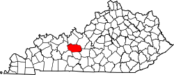
County Grayson
Elevation
771 ft (235 m)
Time zone UTC-6 (Central (CST))
  Summer (DST) UTC-5 (CDT)
ZIP codes
42754
Area code(s) 270 and 364
GNIS feature ID507402 [1]

Anneta is an unincorporated community located in southern Grayson County, Kentucky, United States. [2]

Contents

History

The community was named after the daughter of Peter Decker, the community's first postmaster, in 1884. The post office, originally known as Decker at its November 1882 establishment, would later relocate less than two years later, [3] and would remain in operation until the late 1960s.

Geography

Anneta is located about 8 miles (13 km) south-southeast of Leitchfield along Kentucky Route 259 (KY 259).

Education

Students in the area attend Grayson County Schools, including Grayson County High School.

Points of interest in and around Anneta

Nearby cities

References

  1. U.S. Geological Survey Geographic Names Information System: Anneta, Kentucky
  2. “Anneta Populated Place Profile / Grayson County, Kentucky Data”. kentucky.hometownlocator.com. Retrieved January 20, 2022.
  3. Decker, Christi (March 25, 2004). "Community Perspectives: All About Anneta". Grayson County News Gazette . Leitchfield, Kentucky. p. 22. Retrieved April 19, 2025 via Google Books.
  4. Loucon Training and Retreat Center