Antsla | |
|---|---|
Town | |
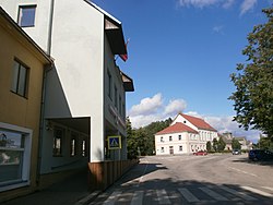 Town center | |
 Antsla Location in Estonia | |
| Coordinates: 57°49′45″N26°31′44″E / 57.82917°N 26.52889°E | |
| Country | |
| County | |
| Municipality | |
| Population (2024) [1] | |
• Total | 1,211 |
| • Rank | 39th |
| Time zone | UTC+2 (EET) |
| • Summer (DST) | UTC+3 (EEST) |
Antsla (German : Anzen) is a town in Võru County, southern Estonia, it is the administrative seat of Antsla Parish.
Contents
The borough of Antsla was reclassified as a third-rank town by Konstantin Päts on 1 May 1938. The settlement was first attested in 1405. The town has a furniture factory.
During the Second World War, Soviet forces captured Antsla in August 1944; German losses included hundreds of troops and large quantities of equipment. [2]
Antsla is located on the Valga–Pechory railway, but train traffic on the line has been inactive since 2001.

