This article needs additional citations for verification .(February 2020) |
Kiviõli | |
|---|---|
 | |
 Flag  Coat of arms | |
 Kiviõli Location in Estonia | |
| Coordinates: 59°21′N26°58′E / 59.350°N 26.967°E | |
| Country | |
| County | |
| Municipality | |
| Founded | 1922 |
| Town rights | 1946 |
| Area | |
• Total | 11.75 km2 (4.54 sq mi) |
| Population (2024) [1] | |
• Total | 4,792 |
| • Rank | 23rd |
| • Density | 410/km2 (1,100/sq mi) |
| Ethnicity | |
| • Estonians | 39.6% |
| • Russians | 51.5% |
| • other | 8.9% |
| Time zone | UTC+2 (EET) |
| • Summer (DST) | UTC+3 (EEST) |
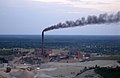
Kiviõli ( /ˌkɪviˈoʊli/ KIV-ee-OHL-ee; Estonian: [ˈkiviɤlʲi] ) is an industrial town in Ida-Viru County, Estonia, established in 1922. The main industry in the town is oil shale mining, which gives the town its name.