Apperley Viaducts

Last updated

Apperley Viaducts
Apperley Viaduct, Apperley Bridge, Bradford - geograph.org.uk - 4878963.jpg
Coordinates 53°50′31″N1°42′36″W / 53.842°N 1.710°W / 53.842; -1.710
Carries Airedale line
Crosses River Aire
Locale Apperley Bridge, West Yorkshire, England
Characteristics
Total length7 chains (460 ft; 140 m)
No. of spans10
Rail characteristics
No. of tracks 2
Track gauge 4 ft 8+12 in (1,435 mm) standard gauge
Electrified Overhead catenary
History
Opened1900
Location
Apperley Viaducts

The Apperley Viaducts are two adjacent railway viaducts straddling the River Aire in West Yorkshire, England. The open viaduct dates back to 1900, carrying the current double track Airedale line railway, whereas the redundant adjacent viaduct (to the immediate west) dates back to 1867, and was built to replace the original bridge at this point which collapsed in November 1866 due to severe flooding. The viaducts are two of the many railway crossings of the River Aire between Shipley and Leeds.

Contents

History

The first bridge over the Aire at this point was opened with the railway in May 1846, [1] when the inaugural train stopped at the viaduct to inspect the earthworks. [2] The first viaduct was 156 yards (143 m) long with ten arches, and carried up to 200 trains per day. [3] [4] Severe flooding in 1866 meant that instead of the river flowing through three arches, which it did normally, it was flooding through all ten arches of the viaduct by 16 November. [5] [6] This caused enough damage to the viaduct that it collapsed into the river in a matter of moments. [7] The 4:50 pm train from Bradford Market Street railway station crossed the viaduct after 5 o'clock and the guard reported to the stationmaster at Apperley Bridge station that he felt the viaduct was "insecure". [8] The signals were thrown to danger, and the station staff at Apperley Bridge station ran out to the viaduct to warn an approaching train - a 5:00 pm service from Bradford. However, it could not be stopped in time and it ran onto the viaduct, which sagged visibly with the weight of the train resting upon it, and the crew scrambled for the safety of the west of the viaduct, with the station staff from Apperley Bridge retreating to the east end of the viaduct. [9] Barely had the respective parties reached either end of the viaduct, when a loud crack was heard, and both the viaduct and train dropped into the river. [10]

A specialist locomotive recovery team had to wait for three days before they could get to the locomotive. The team inserted rails underneath the engine and used windlasses to retrieve the locomotive. It was then taken up an incline back onto the main running lines. [11] The piers were rebuilt and new girders delivered, with traffic resuming across the new viaduct in early 1867. [12] The girders were rolled from steel plates at an ironworks in Stanningley, and weighed over 500 tonnes (550 tons). [13] The 1867 viaduct was designed and engineered by the team of Benton and Woodiwiss, who would go on to fulfil some of the contracts on the Settle and Carlisle Railway for the Midland Railway Company. [14]

Initially, during the new build works, trains were terminated at Apperley Bridge and Shipley, with many through passengers being taken from Leeds to Bradford Adolphus Street, and walking through the city to Market Street (Forster Square station), before being taken onwards. [15] By the 24 November, trains were terminating either side of the viaduct and passengers walked across the river on a wooden footbridge, some 4–5 yards (3.7–4.6 m) wide, which connected them between the trains rather than transferring across Bradford. [16] [10]

At the northern end of the eastern viaduct (the one still in use) was a small siding that led down to Esholt Sewage Farm. [17] [18] The current viaduct which is in use, was constructed between 1899 and 1900 when the lines between Leeds and Shipley were quadrupled with the lines and viaducts being parallel to each other, (the nearby Thackley Tunnel having another bore cut through the hill also). [19] [20] [21] The viaduct is one of eight crossings over the River Aire by the railway line between Leeds and Shipley, and is 7 chains (460 ft; 140 m) long. [21] [22]

See also

Related Research Articles

<span class="mw-page-title-main">Wharfedale line</span> Railway line in England

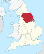
The Wharfedale line is one of the rail services in the West Yorkshire Metro area of northern England. The service connects Ilkley with Leeds and Bradford, and is operated by Northern Trains. West Yorkshire Metrocards are available for use on the line, covering Zones 3–5. The line is served predominantly by four-coach Class 333 electric multiple units.

<span class="mw-page-title-main">Airedale line</span> Rail line in Yorkshire, England

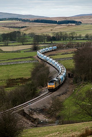
The Airedale line is one of the rail services in the West Yorkshire Metro area centred on West Yorkshire in northern England. The service is operated by Northern, on the route connecting Leeds and Bradford with Skipton. Some services along the line continue to Morecambe or Carlisle. The route covered by the service was historically part of the Midland Railway.

<span class="mw-page-title-main">Bradford Forster Square railway station</span> Railway station in West Yorkshire, England

Bradford Forster Square railway station serves Bradford, West Yorkshire, England. The majority of services to/from station use Class 333 electric multiple units operated by Northern Trains; they run on the Airedale line to Skipton, the Wharfedale line to Ilkley and the Leeds-Bradford line to Leeds.

<span class="mw-page-title-main">Shipley railway station</span> Railway station in West Yorkshire, England

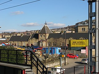
Shipley railway station serves the market town of Shipley in West Yorkshire, England. It is 2+34 miles (4.4 km) north of Bradford Forster Square and 10+34 miles (17.3 km) north-west of Leeds.

<span class="mw-page-title-main">Frizinghall railway station</span> Railway station in West Yorkshire, England

Frizinghall railway station is situated in the Frizinghall district of Bradford, West Yorkshire, England. The station, an unstaffed halt 2 miles (3 km) north of Bradford Forster Square is on the Airedale Line, and all trains serving it are operated by Northern Trains.

<span class="mw-page-title-main">Saltaire railway station</span> Railway station in West Yorkshire, England

Saltaire railway station serves the Victorian model village of Saltaire near Shipley in West Yorkshire, England. It is situated 3+12 miles (6 km) north of Bradford Forster Square.

<span class="mw-page-title-main">Bingley railway station</span> Railway station in West Yorkshire, England

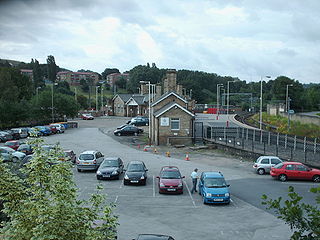
Bingley railway station is a grade II listed railway station that serves the market town of Bingley in West Yorkshire, England, and is 13.5 miles (21.7 km) away from Leeds and 5.5 miles (8.9 km) away from Bradford Forster Square on the Airedale line operated by Northern Trains.

<span class="mw-page-title-main">Skipton railway station</span> Railway station in North Yorkshire, England

Skipton railway station is a Grade II listed station which serves the market town of Skipton in North Yorkshire, England on the Airedale Line, which gives Skipton access to destinations such as Leeds, Bradford, Carlisle, Lancaster and Morecambe. The station is operated by Northern Trains and is situated 27 miles (43 km) north-west of Leeds.

The Leeds and Bradford Railway Company (L&BR) opened a railway line between the towns on 1 July 1846. It extended its line from Shipley through Keighley to Skipton and Colne, in 1847 and 1848.

<span class="mw-page-title-main">Apperley Bridge railway station</span> Railway station in West Yorkshire, England

Apperley Bridge station is situated in Bradford on the line between Leeds and Shipley, West Yorkshire, England. It serves the district of Apperley Bridge in the north-east of the city.

<span class="mw-page-title-main">Yorkshire Dales Railway</span> Railway line in North Yorkshire, England

The Yorkshire Dales Railway was a branch line linking the town of Skipton with the villages of Rylstone, Threshfield and Grassington in North Yorkshire, England. There were two stations on the line - Grassington & Threshfield and Rylstone - and a connection via the Skipton to Ilkley Line to Skipton.

<span class="mw-page-title-main">Leeds and Bradford Extension Railway</span> Former UK railway company

The Leeds and Bradford Extension Railway was an early British railway company in the West Riding of Yorkshire. It built a line from Shipley near Bradford through Keighley and Skipton to Colne. The Skipton–Colne Line closed in 1970, but the remainder of the line is still in use today, and once formed part of the Midland Railway's main line route from London to Glasgow.

<span class="mw-page-title-main">Kildwick and Crosshills railway station</span> Disused railway station in North Yorkshire, England

Kildwick and Crosshills [sic] was a railway station off Station Road in Cross Hills, North Yorkshire, England. It served the villages of Cross Hills, Cowling, Glusburn, Kildwick and Sutton-in-Craven.

<span class="mw-page-title-main">Kirkstall Forge railway station</span> Railway station in Leeds, West Yorkshire

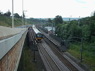
Kirkstall Forge railway station is a station serving the Kirkstall area of Leeds, West Yorkshire, England. It is on the Leeds to Bradford Line between Leeds City and Shipley and was opened on 19 June 2016, near the site of an earlier station with the same name.

<span class="mw-page-title-main">Otley and Ilkley Joint Railway</span> United Kingdom legislation

The Otley and Ilkley Joint Railway was a railway line running between the towns of Otley and Ilkley in West Yorkshire. The line was managed and run jointly by the Midland Railway (MR) and the North Eastern Railway (NER) and was 6+12 miles (10 km) long. Opened to passenger traffic on 1 August 1865 and freight traffic some months later, the line ran for almost 100 years before partial closure in July 1965 when the line to Otley closed. Today passenger services run over the rest of the line as part of the West Yorkshire Passenger Transport Executive (WYPTE) Wharfedale Line.

<span class="mw-page-title-main">Shipley Great Northern Railway branch line</span> Disused railway line in West Yorkshire, England

The Shipley Great Northern Railway branch line was a railway line that ran east, south and then westwards from Shipley to Bradford in West Yorkshire, England. The route was opened in 1874 to goods traffic and then to passengers in 1875 by the Great Northern Railway (GNR) and looped around the eastern edge of Bradford. The GNR arrived after other railways had been established in the West Yorkshire area and many of their lines were heavily reliant on tunnels and grand viaducts, the Shipley and Windhill line being an exception to this, although it did have some steep gradients. The branch extended for 8.5 miles (13.7 km) between the two terminuses of Shipley Windhill and Bradford Exchange. The route as built from Laisterdyke to Shipley was actually only 6.5 miles (10.5 km) as the initial section from Bradford Exchange to Laisterdyke was already in existence as part of the Great Northern Railway's line to Leeds.

<span class="mw-page-title-main">Esholt Sewage Works Railway</span> Former industrial railway in West Yorkshire, England

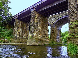
Esholt Sewage Works Railway was a standard gauge works railway constructed in 1910 to serve a sewage works in Esholt, West Yorkshire, England.

<span class="mw-page-title-main">Newlay and Horsforth railway station</span> Disused railway station in West Yorkshire, England

Newlay and Horsforth railway station, until 1889 and from 1961 called Newlay station, was a station on the route of the former Leeds and Bradford Railway, located on the right bank of the River Aire and on the left bank of the Leeds and Liverpool canal between Horsforth in the north and Bramley in the south. It was accessed from Pollard Lane, which still crosses the railway on a bridge there, and served mainly the southern parts of Horsforth in West Yorkshire, England.

<span class="mw-page-title-main">Thwaites railway station</span> Disused railway station in West Yorkshire, England

Thwaites railway station was a railway station located just east of Keighley, West Riding of Yorkshire, on the Midland Railway line through the Aire Valley between Keighley and Shipley. It opened to traffic in 1892 and closed 17 years later in 1909 due to poor patronage.

References

  1. Stretton, Clement Edwin (1901). The history of the Midland railway. London: Methuen & Company. p. 117. OCLC   6011687.
  2. Binns, Donald (1984). Steam in Airedale. Skipton: Wyvern Publications. p. 4. ISBN   0-907941-11-7.
  3. Alvin 2015, p. 2.
  4. "The Floods in the Northern Counties". The Times. No. 25659. 19 November 1866. p. 10. ISSN   0140-0460.
  5. Bairstow 2004, p. 36.
  6. Gough, John (1989). The Midland Railway: a chronology. Leicester: Railway and Canal Historical Society. p. 166. ISBN   0901461121.
  7. Williams 1888, p. 337.
  8. Alvin 2015, p. 3.
  9. Clayton, Emma (6 January 2016). "The day Apperley Viaduct was washed away in floods". Bradford Telegraph and Argus. Retrieved 1 April 2024.
  10. 1 2 Alvin 2015, p. 4.
  11. Williams 1888, p. 338.
  12. Williams 1888, p. 341.
  13. "Local and General". The Leeds Mercury. No. 8964. 5 January 1867. p. 7. OCLC   719815283.
  14. Skempton, Alec, ed. (2008). Biographical dictionary of civil engineers in Great Britain and Ireland. London: T. Telford. p. 853. ISBN   978-0-7277-3504-1.
  15. Bairstow 2004, pp. 36–37.
  16. Binns, Donald (1984). Steam in Airedale. Skipton: Wyvern Publications. p. 16. ISBN   0-907941-11-7.
  17. "View map: Great Britain. Ordnance Survey, SE13 - D//* (includes: Baildon; Bradford; Clayton; Eccleshill; Idle; Shipley) - Ordnance Survey 1:25... - Ordnance Survey 1:25,000 maps of Great Britain, 1945-1969". maps.nls.uk. 1952. Retrieved 1 April 2024. Located at SE189386
  18. Chapman, Stephen (1995). Railway Memories No.7: Airedale & Wharfedale. Todmorden: Bellcode Books. p. 26. ISBN   1-871233-05-4.
  19. Alvin 2015, p. 5.
  20. "Multiple News Items". Nottinghamshire Guardian. No. 2829. 12 August 1899. p. 5. OCLC   221918675.
  21. 1 2 Bairstow 2004, p. 13.
  22. Kelman, Leanne (2020). Railway Track Diagrams Book 2: Eastern (5 ed.). Frome: Trackmaps. 41. ISBN   978-1-9996271-3-3.

Sources