Kirkstall is a north-western suburb of Leeds, West Yorkshire, England, on the eastern side of the River Aire. The area sits in the Kirkstall ward of Leeds City Council and Leeds West parliamentary constituency, represented by Rachel Reeves. The population of the ward at the 2011 Census was 21,709.

Airedale is a valley, or dale, in North Yorkshire and West Yorkshire, England. It is named after the River Aire, which flows through it. The upper valley, from Malham Cove to Airton, is known as Malhamdale, named after the village of Malham. At Airton the valley widens and becomes Airedale proper. The river flows past Skipton on to Keighley, Bingley, Shipley, and Leeds.
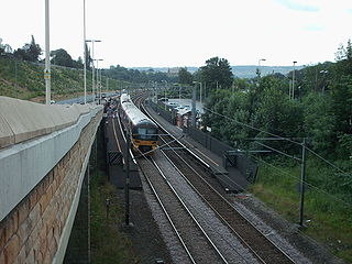
The Airedale line is one of the rail services in the West Yorkshire Metro area centred on West Yorkshire in northern England. The service is operated by Northern, on the route connecting Leeds and Bradford with Skipton. Some services along the line continue to Morecambe or Carlisle. The route covered by the service was historically part of the Midland Railway.

The Abbey Light Railway was a 2 ft narrow gauge railway in Kirkstall, Leeds, West Yorkshire, England. Built by enthusiasts, the Railway ran from the nearby Bridge Road commercial area into the grounds of Kirkstall Abbey, operating most Sundays.
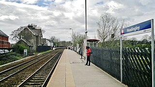
Headingley railway station is off Kirkstall Lane in Leeds, West Yorkshire, England, on the Harrogate Line, 3 miles (5 km) north west of Leeds. The station was opened in 1849 by the Leeds & Thirsk Railway, later part of the Leeds Northern Railway to Northallerton.

Burley is an inner city area of Leeds, West Yorkshire, England, 1 mile (1.6 km) north-west of Leeds city centre, between the A65 Kirkstall Road at the south and Headingley at the north, in the Kirkstall ward.

The Leeds Industrial Museum at Armley Mills is a museum of industrial heritage located in Armley, near Leeds, in West Yorkshire, Northern England. The museum includes collections of textile machinery, railway equipment and heavy engineering amongst others.

Apperley Bridge is a village in the metropolitan borough of the City of Bradford, in West Yorkshire, England in the Idle and Thackley Ward. Apperley Bridge is north-east of Bradford on the boundary with the City of Leeds bounded in the east by Carr Beck and to the south by Greengates. The village straddles the Leeds and Liverpool Canal and the River Aire. It takes its name from the old bridge over the river on Apperley Lane.

Thomas Grainger FRSE was a Scottish civil engineer and surveyor. He was joint partner with John Miller in the prominent engineering firm of Grainger & Miller.

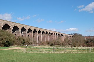
Bramhope Tunnel is on the Harrogate Line between Horsforth station and the Arthington Viaduct in West Yorkshire, England. Services through the railway tunnel are operated mainly by Northern. The tunnel was constructed during 1845–1849 by the Leeds and Thirsk Railway. It is notable for its 2.138-mile (3.441 km) length and its Grade II listed, crenellated north portal. The deaths of 24 men who were killed during its construction are commemorated in Otley churchyard by a monument that is a replica of the tunnel's north portal.

The River Irwell Railway Bridge was built for the Liverpool & Manchester Railway (L&MR), the world's first passenger railway which used only steam locomotives and operated as a scheduled service, near Water Street in Manchester, England. The stone railway bridge, built in 1830 by George Stephenson, was part of Liverpool Road railway station. The bridge was designated a Grade I listed building on 19 June 1988.

The Leeds Northern Railway (LNR), originally the Leeds and Thirsk Railway, was an English railway company that built and opened a line from Leeds to Stockton via Harrogate and Thirsk. In 1845 the Leeds and Thirsk Railway received permission for a line from Leeds to Thirsk, part of which opened in 1848, but problems building the Bramhope Tunnel delayed trains operating into Leeds until 1849.
The East and West Yorkshire Junction Railway was a railway company established in 1846 between the Leeds and Thirsk Railway at Knaresborough and the York, Newcastle and Berwick Railway near York, England. The company merged into the York and North Midland Railway in 1852.

Arthington Viaduct, listed known as the Wharfedale Viaduct, carries the Harrogate Line across the Wharfe valley between Arthington in West Yorkshire and Castley in North Yorkshire, England. It is a Grade II listed structure.
The Chappel Viaduct is a railway viaduct that crosses the River Colne in the Colne Valley in Essex, England. It carries the Gainsborough Line which now is a short branch linking Marks Tey in Essex to Sudbury in Suffolk. The line previously, however, extended to Shelford in Cambridgeshire.

Kirkstall Bridge is a Grade II listed road bridge in Kirkstall, City of Leeds, West Yorkshire, leading the B6157 road across the River Aire and the railway line between Leeds and Shipley.

Knaresborough Viaduct is a viaduct in the North Yorkshire town of Knaresborough, England. The viaduct carries the Harrogate line over the River Nidd in the town. The viaduct was supposed to have opened in 1848, but the first construction collapsed into the river very near to completion, which necessitated a new viaduct and delayed the opening of the line through Knaresborough by three years.
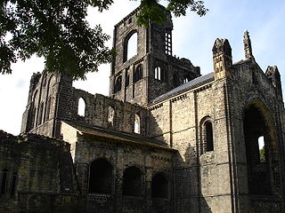
Kirkstall is a ward in the metropolitan borough of the City of Leeds, West Yorkshire, England. It contains 48 listed buildings that are recorded in the National Heritage List for England. Of these, one is listed at Grade I, the highest of the three grades, two are at Grade II*, the middle grade, and the others are at Grade II, the lowest grade. The ward contains Kirkstall, Burley and Hawksworth, all suburbs of Leeds. The River Aire and the Leeds and Liverpool Canal pass through the ward, and the listed buildings associated with these are weirs, sluices, locks, and a canal bridge. The most important building is the ward is Kirkstall Abbey, which is listed, together with associated structures. The other listed buildings include houses and associated structures, churches and items in churchyards, public houses, a school and a former Sunday school, a commemorative arch, road bridges, a railway viaduct and station, former mill buildings, buildings associated with a former forge, and a war memorial.

Newlay is a suburb of Horsforth, in West Yorkshire, England. Originally a hamlet, it is now part of Horsforth parish in the City of Leeds District, and has its own conservation area. Newlay is situated on the Leeds and Liverpool Canal and the River Aire, some 5 miles (8 km) north west of Leeds city centre.