Staithes Viaduct

Last updated

Staithes Viaduct
Staithes viaduct.jpg
Staithes viaduct
Coordinates 54°33′22″N0°47′42″W / 54.556°N 0.795°W / 54.556; -0.795 Coordinates: 54°33′22″N0°47′42″W / 54.556°N 0.795°W / 54.556; -0.795
OS grid reference NZ775189
CrossesStaithes Beck [note 1]
Locale Staithes, North Yorkshire, England
Preceded by Kilton Viaduct (northwards)
Characteristics
MaterialIron and concrete
Total length790 feet (240 m)
Height152 feet (46 m)
No. of spans17
Piers in water1
Rail characteristics
No. of tracks 1
History
Fabrication bySkerne Works
Opened1875
Closed1958
Location
Staithes Viaduct

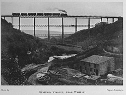
Staithes Viaduct was a railway bridge that straddled Staithes Beck at Staithes, Yorkshire, England. It was north of the closed Staithes railway station. It was known for an anemometer, a fitting to tell the signaller if winds across the viaduct were too strong for crossing trains.

Contents

Major crossing structures, including the viaduct, on the Whitby to Loftus line were made out of iron, with the piers additionally filled with concrete. The viaduct started to be built in 1875 and opened in 1883 – due to financial, build and ownership problems. The line closed in 1958 and the viaduct demolished in 1960.

History

The Whitby, Redcar and Middlesbrough Union Railway (WR&MUR) was built in the 1870s, but the construction of the line was beset by financial and geological problems. [2] Staithes viaduct was originally built in 1875, but traffic did not start until 1883. [3] The viaduct was constructed from tubular iron filled with concrete, with seventeen spans; six spans of 60 feet (18 m) in the middle of the bridge, and a further combined eleven spans at either end of the bridge measuring 30 feet (9.1 m) each. [4] The bridge was 790 feet (240 m) long, and was elevated 152 feet (46 m) above Staithes Beck, [5] with one of the piers sunk into the riverbed. [6] The piers of the viaduct were constructed of tubular steel, filled with concrete. [7] As built, the viaduct did not have the strengthening spars running horizontally through the piers; these were added in eight years after opening, with some stating that it was a reaction to the Tay Bridge disaster. [8]

The coast routes from Whitby were deemed to be awkward to build in terms of geology and necessitating large engineering programmes such as tunnels, embankments and bridges. The WR&MUR line was abandoned by the original contractors due to financial problems, and the NER took over the line, but had to effectively rebuild many of the tunnels and bridges. [9] The viaduct at Staithes was no exception; the tubes of the piers were supposed to have been filled with concrete, and when they were opened, it was found that only gravel had been poured into the tubes. So concrete made from local sandstone mixed with Portland cement was inserted as per the original intention. [10] These extra works further delayed opening of the line by two years, with the line opening in 1883 instead of 1881. [11] The line was assessed at least twice by a government inspector, with various recommendations for improvement of works. One report submitted by Major-General Hutchinson noted defects in at least three of the piers of Staithes Viaduct, and also was the first to mention a wind gauge and possible speed restrictions. [12]

The design was that of John Dixon, and the original contractor was Paddy Waddell. [6] The ironwork for the viaduct was constructed off site at the Skerne Iron Works, in Albert Hill, Darlington. [13] [14] The same company provided all the ironwork for the other four viaducts on the Whitby-Loftus line, however, the viaduct at Staithes was the tallest and longest, [15] being described as "spectacular". [16] The cross-sections of iron were also fabricated by the Skerne Works and were of heavy iron bars. [17] The diameter of the pier tubes on the 30-foot (9.1 m) spans was 2 feet 6 inches (0.76 m), with the same thickness at the top of the 60-foot (18 m) spans, however they tapered to 4 feet 6 inches (1.37 m) at the bottom. [18]

Staithes viaduct under construction Staithes viaduct, WR&MUR, construction.jpg
Staithes viaduct under construction

A diagram from the time shows the viaduct being erected from the south side of the ravine by a steam crane, but the question of how the iron was delivered to the site remains unanswered. As the nearest railhead was at Loftus, some 5 miles (8 km) to the north, an overland route seems unlikely. Williams postulates that the iron sections were delivered by sea to the small harbour at Staithes. [19]

In 1884 the North Eastern Railway installed an anemometer on the viaduct that was designed to ring a bell in Staithes signal box should the force of the wind reach a pressure greater than 28 pounds per square foot (1.3 kPa). [20] This would prompt a track investigation. In March of 1884, the NER issued instructions that the line speed across the viaduct was 20 miles per hour (32 km/h) and that if a storm rang the bell in the signal box, all effort should be made to stop southbound trains travelling over the viaduct if they were on their way. However, northbound trains were allowed to draw up into, and wait at, the station. [19] In 1935, the LNER stated that the system had hardly been used, [21] however, because of concerns about the winds across the viaduct, the equipment was replaced in 1946. [22]

The line was closed in May 1958, and the viaduct was dismantled two years later in 1960. British Rail stated that the cost of maintaining the five iron viaducts and tunnels on the line would cost over £57,000. All that remains of the structure at Staithes is the western abutment made of stone. The eastern abutment, and the associated station area, have disappeared under a housing development. [23] The structure is remembered by a plaque in the village with details on the viaduct. [5]

The last windspeed anenometer used on the viaduct is now in the collection of the National Railway Museum in York. [24]

Notes

  1. Ordnance Survey mapping shows the water beneath to be named Staithes Beck. It has also been described as Roxby Beck, with the steep ravine known as the valley of Dalehouse Beck. [1]

Related Research Articles

Tay Bridge Railway bridge across the River Tay, Scotland

The Tay Bridge carries the railway across the Firth of Tay in Scotland between Dundee and the suburb of Wormit in Fife. Its span is 2.75 miles. It is the second bridge to occupy the site.

Whitby railway station Railway station in North Yorkshire, England

Whitby is a railway station at the head of the Esk Valley Line, which runs between Middlesbrough and Whitby via Nunthorpe. The station, situated 6 miles 24 chains (10.1 km) east of Grosmont, serves the seaside town of Whitby, Borough of Scarborough in North Yorkshire, England. It is owned by Network Rail and managed by Northern Trains. The station is also served by heritage services operated by the North Yorkshire Moors Railway.

Appersett Hamlet in Wensleydale, North Yorkshire, England

Appersett is a hamlet in the Yorkshire Dales in the Richmondshire district of North Yorkshire, England one mile (1.6 km) west of Hawes. It lies on the A684 road and an unclassified road runs alongside Widdale Beck to connect with the B6255 road between Hawes and Ingleton.

Bennerley Viaduct Railway viaduct spanning the Erewash Valley

The Bennerley Viaduct is a disused railway viaduct spanning the Erewash Valley between Awsworth (Nottinghamshire) and Ilkeston (Derbyshire) in central England. It was built in 1877 but closed to rail traffic in 1968, as part of the Beeching cuts. It was sold to conservation group Railway Paths Ltd in 2001.

York and North Midland Railway

The York and North Midland Railway (Y&NMR) was an English railway company that opened in 1839 connecting York with the Leeds and Selby Railway, and in 1840 extended this line to meet the North Midland Railway at Normanton near Leeds. Its first chairman was the railway financier George Hudson, who had been called the railway king.

Whitby, Redcar and Middlesbrough Union Railway Disused railway line in Yorkshire, England

The Whitby, Redcar and Middlesbrough Union Railway (WRMU), a.k.a. the Whitby–Loftus Line, was a railway line in North Yorkshire, England, built between 1871 and 1886, running from Loftus on the Yorkshire coast to the Esk at Whitby, and connecting Middlesbrough to Whitby along the coast.

Ravenscar railway station Former railway station in the North Riding of Yorkshire, England

Ravenscar was a railway station on the Scarborough & Whitby Railway and served the village of Ravenscar, North Yorkshire, England.

Whitby West Cliff railway station Former railway station in the North Riding of Yorkshire, England

Whitby West Cliff railway station was a railway station on the Whitby Redcar and Middlesbrough Union Railway. It was opened on 3 December 1883, to serve the West Cliff area of the town of Whitby, North Yorkshire, England. It was one of two stations serving Whitby; the other was Whitby Town railway station, which served the lines to Malton and Battersby.

Sandsend railway station Former railway station in the North Riding of Yorkshire, England

Sandsend railway station was a railway station on the Whitby, Redcar and Middlesbrough Union Railway. It was opened on 3 December 1883, and served the villages of Sandsend and Lythe. It closed on 5 May 1958. The station building is now a private residence. It was the only station between Whitby and Loftus not to possess a passing loop.

Hinderwell railway station Former railway station in the North Riding of Yorkshire, England

Hinderwell railway station was a railway station on the Whitby Redcar and Middlesbrough Union Railway. It was opened on 3 December 1883, and served the villages of Hinderwell and Runswick Bay. Like most stations on the line between Loftus and Whitby West Cliff, it was built with a passing loop. However, the northbound side was not furnished with a platform until 1908. The station closed to all traffic on 5 May 1958.

Staithes railway station Former railway station in the North Riding of Yorkshire, England

Staithes railway station was a railway station on the Whitby Redcar and Middlesbrough Union Railway, serving the villages of Staithes and Dalehouse in North Yorkshire, England. It was opened on 3 December 1883.

Castielertobel Viaduct

The Castielertobel Viaduct is a single track railway bridge spanning the Castielertobelbach, and linking the municipalities of Castiel and Calfreisen, in the Canton of Graubünden, Switzerland. It was built between 1913 and 1914 for the Chur–Arosa railway, and is now owned and used by the Rhaetian Railway.

Sandsend Village in North Yorkshire, England

Sandsend is a small fishing village, near to Whitby in the Scarborough district of North Yorkshire, England. It forms part of the civil parish of Lythe. It is the birthplace of fishing magnate George Pyman. Originally two villages, Sandsend and East Row, the united Sandsend has a pub and restaurant. A large part of the western side of the village, in The Valley, is still owned by Mulgrave Estate. The Valley is one of the most expensive areas to buy property on the Yorkshire Coast.

Sandsend Tunnel

Sandsend Tunnel is a tunnel on the former Whitby, Redcar and Middlesbrough Union Railway that was opened in 1883 and closed in 1958. The rail line that ran through it was originally intended to travel along the top of the cliffs, however some of the cliff fell into the sea whilst construction was suspended so the NER constructed two tunnels, the Sandsend Tunnel and the Kettleness Tunnel.

Walnut Tree Viaduct

Walnut Tree Viaduct was a railway viaduct located above the southern edge of the village of Taffs Well, South Wales. Originally built to carry the Barry Railway across a narrow gorge through which the River Taff, Taff Vale Railway and Cardiff Railway passed, it was deconstructed in 1969, leaving only two of the support columns visible from the A470 road.

Monmouth Viaduct

The Monmouth Viaduct or Chippenham Meadow Viaduct is a 20-arch 183m red sandstone viaduct, with two 23m steel lattice-girder spans over the river. It carried the Coleford, Monmouth, Usk & Pontypool Railway line across the River Wye at Monmouth, Wales. A further river crossing by the Ross and Monmouth Railway was later built nearby.

Goole railway swing bridge Swing bridge in the East Riding of Yorkshire, England

The Skelton Viaduct, also known as the Hook bridge or Goole railway swing bridge, is a large viaducted hogback plate girder bridge with swing span over the River Ouse, Yorkshire near Goole, East Riding of Yorkshire, England. The bridge was designed by Thomas Elliot Harrison for the Hull and Doncaster Branch of the North Eastern Railway and opened in 1869.

Kettleness Hamlet in North Yorkshire, England

Kettleness, is a hamlet in the Scarborough District of North Yorkshire, England. The settlement only consists of half-a-dozen houses, but up until the early 19th century, it was a much larger village. However, most of that village, which was on the headland, slipped into the sea as a result of instability caused by quarrying for the alum industry. Kettleness became a smaller settlement, with houses rebuilt slightly further inland.

Grinkle Mine Former ironstone mine in North Yorkshire, England

Grinkle Mine, was an ironstone mine working the main Cleveland Seam near to Roxby in North Yorkshire, England. Initially, the ironstone was mined specifically for the furnaces at the Palmer Shipbuilders in Jarrow on the River Tyne, but later, the mine became independent of Palmers. To enable the output from the mine to be exported, a 3-mile (4.8 km) narrow-gauge tramway was constructed that ran across three viaducts and through two tunnels to the harbour of Port Mulgrave, where ships would take the ore directly to Tyneside.

Kilton Viaduct Viaduct in Yorkshire, England

Kilton Viaduct was a railway viaduct that straddled Kilton Beck, near to Loftus, in North Yorkshire, England. The viaduct was opened to traffic in 1867, however in 1911, with the viaduct suffering subsidence from the nearby ironstone mining, the whole structure was encased in waste material from the mines creating an embankment which re-opened fully to traffic in 1913. The railway closed in 1963, but then in 1974, it re-opened as part of the freight line to Boulby Mine carrying potash traffic.

References

  1. Carter, Ernest Frank (1963). The railway encyclopaedia. London: Starke. p. 305. OCLC   11931902.
  2. Hoole 1986, p. 68.
  3. "Disused Stations: Staithes Station". www.disused-stations.org.uk. Retrieved 15 May 2021.
  4. Forrest, W R L (January 1897). "Strengthening the East Row and Upgang Viaducts on the Whitby and Loftus Railway". Minutes of the Proceedings of the Institution of Civil Engineers. 130 (1897): 234. doi:10.1680/imotp.1897.19267.
  5. 1 2 "Nostalgia on Tuesday: Happy landing". The Yorkshire Post. 8 May 2018. Retrieved 15 May 2021.
  6. 1 2 "Demolished viaducts". www.forgottenrelics.co.uk. Retrieved 17 May 2021.
  7. Tomlinson, William Weaver (1915). The North Eastern Railway; its rise and development. Newcastle-upon-Tyne: Reid. p. 695. OCLC   8890833.
  8. "Lost viaducts brought the coast together" . infoweb.newsbank.com. 6 May 2014. Retrieved 16 May 2021.
  9. Hoole 1986, p. 20–21.
  10. "The Whitby, Redcar, and Middlesbrough Union railway". The York Herald. No. 5757. Column E. 22 July 1875. p. 6.
  11. Hoole 1986, p. 26.
  12. Williams 2010, p. 10.
  13. Hutchinson 1879, p. 105.
  14. "Eye in the sky from the past - No. 14" . infoweb.newsbank.com. 22 December 2000. Retrieved 16 May 2021.
  15. Bairstow, Martin (2008). Railways around Whitby : Scarborough - Whitby - Saltburn, Malton - Goathland - Whitby, Esk Valley, Forge Valley and Gilling lines. Leeds: Martin Bairstow. p. 34. ISBN   978-1-871944-34-1.
  16. Young, Alan (2015). The lost stations of Yorkshire; the North and East Ridings. Kettering: Silver Link. p. 89. ISBN   978-1-85794-453-2.
  17. Hutchinson 1879, p. 110.
  18. Hutchinson 1879, p. 109.
  19. 1 2 Williams, Michael Aufrère. "Tunnels and viaducts of the Whitby-Loftus line". www.forgottenrelics.co.uk. Retrieved 26 May 2021.
  20. Winchester, Clarence, ed. (December 1935). "Trains stopped by gales". Railway Wonders of the World. London: OSV. 47: 1,481. OCLC   964363866.
  21. Dunn, Tim (30 December 2020). "The railway's mechanical marvels". Rail Magazine. No. 921. Peterborough: Bauer Media. p. 58. ISSN   0953-4563.
  22. Champion, Donald L (January 1947). "Pressure Plate Anemometer on Staithes Viaduct, L.N.E.R.". Weather. Royal Meteorological Society. 2 (1): 9. doi:10.1002/j.1477-8696.1947.tb00666.x.
  23. Atterbury, Paul (2009). Discovering Britain's lost railways (2 ed.). Basingstoke: AA. p. 135. ISBN   978-0749563707.
  24. "Wind speed recorder, North Eastern Railway, ex Staithes Viaduct - Science Museum Group Collection". collection.sciencemuseumgroup.org.uk. Retrieved 26 May 2021.

Sources