Royston to Thornhill line

Last updated

Royston to Thornhill line
Dismantled railway near Notton. - geograph.org.uk - 144205.jpg
Dismantled railway near Notton.
Overview
Other name(s)West Riding Lines
StatusClosed
Owner MR (1905 – 1948)
BR (1948 – 1968)
Locale West Yorkshire, England
Stations4 (all goods-only)
Service
Type Heavy rail
History
Openedsee below:
Royston to Thornhill Midland1905
Middlestown Junction to Dewsbury Savile Town1906
Mirfield to Huddersfield Newtown1910
Closed1968 (completely)
Technical
Line length15 miles (24 km) total:
    • Royston – Thornhill 8 miles (13 km)
    • Middlestown Junction – Savile Town 2.5 miles (4 km)
    • Mirfield – Newtown 4.5 miles (7.2 km)
Track gauge 1,435 mm (4 ft 8+12 in) standard gauge

The Royston to Thornhill line was a Midland Railway venture constructed in West Yorkshire, England, that had the intent to allow trains to travel from Sheffield to Bradford without going through Leeds. The scheme, which was promoted as the West Riding Lines, would have travelled underneath Bradford city centre in a long tunnel and ended up in the Aire Valley providing a through line across Bradford. In the event, only the section from Royston to Thornhill, a smaller branch to a goods station at Dewsbury Savile Town, and a longer branch from Mirfield to Huddersfield were ever built. By the late 1960s, the lines had all been closed, however, the viaducts at Bradley, Crigglestone, and Horbury still remain.

Contents

History

The line was promoted by the Midland Railway with a view to shortening the distance needed to travel from London St Pancras to Bradford, [note 1] and also to allow the Midland to make inroads into the Huddersfield, Halifax and Dewsbury areas. [2] The proposal received assent from Parliament in 1898, with a estimated cost of £2.1 million. [3] The length of the entire line between Royston and Bradford was listed as 24 miles (39 km), and the extension would put Bradford on the main line to London. [4] However, only 15 miles (24 km) of the proposed length was ever built; 8 miles (13 km) connecting Royston with Thornhill Junction, 2.5 miles (4 km) connecting to Dewsbury Savile Town, and a 4.5-mile (7.2 km) branch from Mirfield to Huddersfield Newtown. [5]

Construction started in 1902 starting from Royston Junction, and was open from there to Thornhill Junction by November 1905, and into Dewsbury Savile Town by March 1906. [6] [7] Major engineering efforts on the line include viaducts at Horbury Bridge and Calder Grove (Crigglestone), and a 250-yard (230 m) tunnel at Crigglestone. [8] [9] After the Dewsbury branch had crossed the L&YR main line, the line dropped down a 1-in-40 gradient and passed through a 188 yards (172 m) tunnel before arriving at the terminus. [10] The only major structure on the single-track Mirfield to Huddersfield Newtown Branch, was a 15-arch viaduct across the River Colne at Bradley. [11] Had the scheme been carried out to the full plans, a new line would have been constructed along the Spen Valley, and a tunnel would have been required under Bradford for a length of 5,000 yards (4,600 m), which would have started south of Bradford and emerged at the Midland Line from Forster Square [note 2] just 150 yards (140 m) north of the platform ends at Forster Square. [7] After the initial sections of the line were built, the Midland Railway halted any further construction stating that the engineering difficulties of building the line in Bradford were proving too costly. [12] The plans for a line through Spen Valley were shelved when an agreement with the L&YR was reached regarding running powers over the line between Thornhill and Low Moor, thus allowing the Midland into Bradford without the need to build a new line. [13]

One of the conditions attached to the 1898 bill was that the Midland Railway were legally responsible protect the water rights for a water-powered mill in the Ripley area of Bradford. When tunnelling through hills, the normal approach is to drain all water away to the nearest watercourse, but this would have deprived Ripley's mill of its water, preventing it from operating. [14] Consideration was given to a viaduct across Bradford instead of a tunnel, but by 1907, a West Riding Lines Abandonment Bill was being tabled in Parliament for changes to the original bill. [15] By 1910, three express trains per day were leaving Bradford for St Pancras, but using the L&YR lines to Thornhill Midland Junction, and the lack of a through station at Dewsbury (Savile Town was a terminus), led to the Dewsbury Town Council opposing an amended scheme that used running powers of the other lines than a continuation of the line through Dewsbury. [16] The whole project was shelved at the start of the First World War, and never resurrected, with the scheme being formally abandoned in November 1919. [17] [18]

Although the line was furnished with three stations, no passenger traffic called at these, and only the Lancashire & Yorkshire Railway ran local passenger trains over the formation of the line as through trains, with the L&YR possessing running powers over the Midland line as far south as Sheffield. [19] Longer-distance services, such as The Yorkshireman, saw a direct Bradford to London St Pancras (avoiding Leeds) using the line, but this only ran between 1925 and 1939, the service being cut back during the World War II. [20] [21] Most passenger services continued until 1948, but the last services ran over the line in 1968. [22] Middlestown and Crigglestone East stations had goods yards, and they were built with two platforms each, both of these aligned along the main running lines. [23] Dewsbury Savile Town closed in 1950, however, the line was open from Middlestown Junction to Dewsbury well into the early 1960s as a wagon storage facility. [24]

The line was transferred from the London Midland Region of British Rail, to the North Eastern Region in 1957. [25] The bulk of the line was closed in 1968, though the section between Thornhill and Crigglestone Viaduct was kept open to provide materials for the building of the M1 at the eastern end. [26]

The eastern section of line through Notton is now bridleway and cyclepath, connecting with the Trans Pennine Trail in Royston. [27]

A further Midland branch extended from Mirfield to Huddersfield Newtown. The Midland built this line from Mirfield to Huddersfield as the LNWR would not allow the Midland running powers over their Line between Heaton Lodge Junction and Huddersfield. [28] However, the original plan was to extend the line from Middlestown Junction all the way to Huddersfield, but the L&YR consented to allow the Midland Railway to use the section between Thornhill Midland Junction and Mirfield, before the Midland's own branch left southwards at Mirfield station. This benefitted the Midland in reduced costs of a longer line. The line ran for 4.5 miles (7.2 km) and was built as a double track formation, though only one running line was ever laid. [10] [29] Newtown Goods Yard, and the line opened on 1 November 1910. [30] As the LNWR was amalgamated into the Midland at the Grouping of 1923, [31] [note 3] the longer line was deemed unnecessary, and so a connection was made with the main Huddersfield to Heaton Lodge line in 1923 at Red Doles Junction. [33] [34] Thereafter, goods trains from Newtown Yard propelled backwards up the line, so that they were facing the correct way to then run southwards to Hillhouse Yard, and the line to Mirfield from Red Doles Junction closed completely in 1937. [35] This produced a shorter branch of 1 mile 286 yards (1.871 km) between Red Doles and Newtown. [11] Newtown Goods Yard closed in August 1968. [36]

Stations

The viaducts

Crigglestone Viaduct Disused railway viaduct, Calder Grove - geograph.org.uk - 193164.jpg
Crigglestone Viaduct

Horbury Viaduct is 333 yards (304 m) long, 26-foot (7.9 m) wide, and has 17 arches. [41] The viaduct is lower than at Crigglestone as it only reaches a maximum height of 50 feet (15 m), and each span is 45 feet (14 m) across. [42] Crigglestone Viaduct spans the Hallam Line and the A645 road, and used to also run over old colliery workings, and the west to south Horbury curve railway line which closed in 1991. Crigglestone has 21 arches, spanning 1,270 feet (390 m) and is over 82 feet (25 m) high. From west to east, the first 16 arches are 50 feet (15 m) across, the next two are 64 feet (20 m), and the final three are 57 feet (17 m) across. [43]

Crigglestone straddled the coal workings for British Oak and Flockton collieries, the Horbury Curve (also known as the Crigglestone Curve) - a railway line connecting Horbury to the line going south from Wakefield to Barnsley, the A645, and finally, the Wakefield to Barnsley Line itself. [44] Both Horbury and Crigglestone viaducts are built of blue brick, and designed by J. A. McDonald. [43] In 2023, Crigglestone was renovated with repointed brickwork, vegetation cut back, and new bat boxes and bat tubes installed after it was found that pipistrelle bats were living within its structure. [45]

Bradley Viaduct is 255 yards (233 m) long, 90 feet (27 m) high, and has 15 arches. [46] Bradley Viaduct now forms part of the Calder Valley Greenway, and the section of the greenway between the viaduct and Mirfield, is on the former railway trackbed. [47]

See also

Notes

  1. The Midland Railway estimated that the distance between London St Pancras and Bradford would be shorter by 11 miles (18 km). [1]
  2. At that time, the terminus of the Midland Railway at the Northern end of the city centre was known as Market Street. The station was renamed as Forster Square in 1924.
  3. As a preparation for the grouping to take place, the L&YR had already been amalgamated into the LNWR in 1922. [32]

Related Research Articles

<span class="mw-page-title-main">Calder Valley line</span> Railway line in England

The Calder Valley line is a railway route in Northern England between the cities of Leeds and Manchester as well as the seaside resort of Blackpool. It is the slower of the two main rail routes between Leeds and Manchester, and the northernmost of the three main trans-Pennine routes.

<span class="mw-page-title-main">Huddersfield line</span> Inter-regional railway in Northern England

The Huddersfield line is the main railway line between the English cities of Leeds and Manchester, via Huddersfield. It is one of the busiest MetroTrain lines. The route travels south-south-west from Leeds through Dewsbury. After a short westward stretch through Mirfield, where it runs on the ex-L&YR section, it continues south-west through Huddersfield, using the Colne Valley to its headwaters. The long Standedge Tunnel, just after Marsden, crosses under the watershed; the majority of the run down to Manchester is in the Tame Valley. From Manchester, some services continue to Manchester Airport and others to Liverpool.

<span class="mw-page-title-main">Hallam Line</span> Railway line in Yorkshire, England

The Hallam Line is a railway connecting Leeds and Sheffield via Castleford in the West Yorkshire Metro area of northern England. It is a slower route from Leeds to Sheffield than the Wakefield line. Services on this line are operated by Northern Trains. Services from Leeds to Nottingham also use the line.

The Ashton, Stalybridge and Liverpool Junction Railway was opened in 1846 to connect the industrial town of Ashton-under-Lyne to the developing railway network, and in particular to the port of Liverpool. It was a short line, joining the Manchester and Leeds Railway at Miles Platting and the connection to Liverpool was over that line and the Liverpool and Manchester Railway.

<span class="mw-page-title-main">Manchester and Leeds Railway</span> Former British railway company

The Manchester and Leeds Railway was a British railway company that built a line from Manchester to Normanton where it made a junction with the North Midland Railway, over which it relied on running powers to access Leeds. The line followed the valley of the River Calder for much of the way, making for easier gradients but by-passing many important manufacturing towns. Crossing the watershed between Lancashire and Yorkshire required a long tunnel. The line opened throughout in 1841.

<span class="mw-page-title-main">Mirfield railway station</span> Railway station in West Yorkshire, England

Mirfield railway station serves the town of Mirfield in West Yorkshire, England. It lies on the Huddersfield Line and is managed by both Northern and Grand Central train operating companies, and is served by TransPennine Express as well. The station is 4 miles (6 km) north east from Huddersfield.

<span class="mw-page-title-main">Holbeck railway station</span> Railway station in West Yorkshire, England

Holbeck railway station was a railway station that served the district of Holbeck, in Leeds, West Yorkshire, England.

The Queensbury lines was the name given to a number of railway lines in West Yorkshire, England, that linked Bradford, Halifax and Keighley via Queensbury. All the lines were either solely owned by the Great Northern Railway (GNR) or jointly by the GNR and the Lancashire and Yorkshire Railway (L&YR). The terrain was extremely challenging for railway construction, and the lines were very expensive to build. The lines were

<span class="mw-page-title-main">Bradley railway station</span> Disused railway station in West Yorkshire, England

Bradley railway station served the district of Bradley, West Yorkshire, England until closure in 1950.

<span class="mw-page-title-main">Thongs Bridge railway station</span> Disused railway station in West Yorkshire, England

Thongs Bridge railway station was the only intermediate stop on the railway line between Brockholes and Holmfirth, West Yorkshire, England. Opened in July 1850, the station was temporarily closed in 1865 due to the collapse of Mytholmbridge Viaduct. The station closed to passengers permanently in 1959, closing completely in 1965.

<span class="mw-page-title-main">Bradford Exchange railway station</span> Former railway station in Bradford. Yorkshire, England

Bradford Exchange railway station served the city of Bradford, West Riding of Yorkshire, England, from 1850 to 1973, before being replaced by a smaller, new-build station, which was later called Bradford Interchange. Railway lines from Halifax, Queensbury, Wakefield and Leeds met south of the city centre with services terminating in the station. In the British Rail era, many services did not terminate at Exchange station but became through services which reversed in the station to carry on their journey. Exchange station was originally opened in 1850 by the Lancashire & Yorkshire Railway (L&YR) as Drake Street, becoming Exchange in April 1867 with the arrival of services from the Great Northern Railway (GNR).

<span class="mw-page-title-main">Leeds, Bradford and Halifax Junction Railway</span> Railway line in Yorkshire, England

The Leeds, Bradford and Halifax Junction Railway (LB&HJR) was an English railway company. It built a line between Bradford and Leeds, and had running powers over the Lancashire and Yorkshire Railway to Halifax. It opened its main line in 1854 and later built a number of branch lines.

<span class="mw-page-title-main">Heckmondwike Spen railway station</span> Disused railway station in West Yorkshire, England

Heckmondwike Spen was a railway station opened by the London & North Western Railway (LNWR) in Heckmondwike, West Yorkshire, England. The station was one of two in the town of Heckmondwike, the other being Heckmondwike railway station which was opened by the Lancashire & Yorkshire Railway (L&Y). Both stations have been closed and the lines they served have closed too although the formations that they occupied have both been converted into greenways.

<span class="mw-page-title-main">Spen Valley Line</span> Disused railway line in West Yorkshire, England

The Spen Valley Line was a railway that connected Mirfield with Low Moor through the Spen Valley in West Yorkshire, England. Opened up by the Lancashire and Yorkshire Railway in 1847, with full opening to Low Moor in 1848, the line served a busy industrial and textile area and allowed a connection for trains between Huddersfield and Bradford. The line was absorbed by the London & North Western Railway, the London Midland and Scottish Railway (LMS) and British Railways on Nationalisation. A separate link between Heckmondwike Central and Thornhill that opened later and was known as the Ravensthorpe Branch, allowed through running to Wakefield and beyond. The line was closed down to passengers in 1965 with freight continuing sporadically until 1981. A Spur onto the former Leeds New Line from the Ravensthorpe Branch kept the very southern end open until the late 1980s. The majority of the route is now the Spen Valley Greenway cycle path.

<span class="mw-page-title-main">Bradford, Wakefield and Leeds Railway</span> Railway Company

The Bradford, Wakefield and Leeds Railway was an independent railway company that built a line between Wakefield and a junction close to Leeds, in Yorkshire, England. It opened its main line in 1857, and was worked by the Great Northern Railway. The line shortened the GNR route to Leeds.

<span class="mw-page-title-main">Woodkirk railway station</span> Disused railway station in West Yorkshire, England

Woodkirk railway station was a Great Northern Railway (GNR) station on the Batley to Beeston line, which connected Batley to Leeds Central, in West Yorkshire, England. The station opened in July 1890 and was closed in September 1939 to passengers, but the line stayed open until 1964. The station was 1.75 miles (2.82 km) north of Batley railway station, and 6.75 miles (10.86 km) south of Leeds Central railway station.

<span class="mw-page-title-main">Clayton West branch line</span> Former railway line in Yorkshire, England

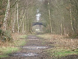
The Clayton West branch line was a standard gauge passenger and freight railway near Huddersfield, in West Yorkshire, England. The line was built by the Lancashire and Yorkshire Railway, opening to traffic in September 1879. Many proposals were considered to extending the line eastwards towards Darton, and then connecting to Barnsley, but these never came to fruition. In 1963, both stations on the line,, were listed for closure under the Beeching cuts, but the branch survived as a passenger carrying railway until 1983. The branch also forwarded coal from two collieries adjacent to the line, which maintained a freight service on the branch up until closure.

<span class="mw-page-title-main">Kirkburton branch</span> Former railway line in Yorkshire, England

The Kirkburton branch was a railway branch in West Yorkshire, England. The line was built by the London and North Western Railway (LNWR) in the 1860s, the only LNWR branch line in the Huddersfield area, although originally, the intention had been to link Kirkburton with Clayton West and through to Barnsley, but this never came to fruition. The line opened to traffic in 1867, and was closed to passengers in 1930. Freight carried on using the branch until 1965. A second railway station for Deighton was opened in 1982 on the main running line between Huddersfield and Mirfield. The removal of passenger services along the branch was down to low passenger numbers; the railway ran along the valley floor and most of the populated areas were high up on the valley sides.

<span class="mw-page-title-main">Heaton Lodge Junction</span> Railway junction in Yorkshire, England

Heaton Lodge Junction is a railway junction on the Trans-Pennine line, which connects Manchester Piccadilly with Leeds via Huddersfield, and the Calder Valley Line through Sowerby Bridge to Wakefield. The line and junctions were historically important as they connected the industrialised areas of Lancashire and Yorkshire.

<span class="mw-page-title-main">Huddersfield Viaduct</span> Railway viaduct in Yorkshire, England

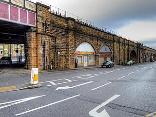
Huddersfield Viaduct is a railway bridge to the north-east of Huddersfield railway station in West Yorkshire, England. The viaduct carries the Huddersfield Line connecting Huddersfield with Dewsbury, Leeds, and York eastwards, and Manchester and Liverpool westwards. The viaduct was built to carry two lines, but was widened in the 1880s to take four tracks, and then reduced to two tracks in 1970. Huddersfield Viaduct is less well-known than other viaducts in the Kirklees area as they are higher, but Huddersfield Viaduct is the longest in the Kirklees district.

References

  1. Batty 1989, p. 91.
  2. Thornhill 1986, p. 39.
  3. Joy 1984, p. 97.
  4. "The Midland Railway in the West Riding". The Railway Times. No. 3, 118. 9 October 1897. p. 492. OCLC   642446180.
  5. Joy 1984, pp. 260–261, 263.
  6. Batty 1989, p. 91–92.
  7. 1 2 Thornhill 1986, p. 41.
  8. Taylor, Kates (2005). Not so merry Wakefield. Barnsley: Wharncliffe. p. 107. ISBN   1-903425-72-7.
  9. 1 2 "The Thornhill and Royston Line, Midland Railway". The Engineer. 108. London: Office for Publishing and Advertisements: 27. 1909. ISSN   0013-7758. OCLC   230064438.
  10. 1 2 Anderson 2000, p. 7.
  11. 1 2 Anderson 2000, p. 96.
  12. Thornhill 1986, pp. 41–42.
  13. Flowers, Andy (August 2023). "Junctions in profile: Heaton Lodge". Today's Railways. No. 258. Sheffield: Platform 5. p. 29. ISSN   1475-9713.
  14. Batty 1989, pp. 92–93.
  15. "Private bills in Parliament". The Guardian. No. 18, 864. 24 January 1907. p. 3. OCLC   697762507.
  16. Batty 1989, p. 94.
  17. Bairstow, Martin (2004). Railways through Airedale & Wharfedale. Farsley: Bairstow. p. 37. ISBN   1-871944-28-7.
  18. Batty 1989, p. 96.
  19. Gough 1989, p. 158.
  20. Joy 1984, p. 99.
  21. Batty 1989, p. 117.
  22. Suggitt, Gordon (2015) [2007]. Lost railways of South & West Yorkshire. Newbury: Countryside Books. p. 140. ISBN   978-1-84674-043-5.
  23. Gough 1989, p. 343.
  24. Wild, Jack; Chapman, Stephen (1998). Railway Memories No. 11: Halifax and the Calder Valley. Todmorden: Bellcode Books. p. 77. ISBN   1-871233-10-0.
  25. "Regional & Other Boundary Changes". s-r-s.org.uk. Retrieved 8 May 2024.
  26. Batty, Stephen (1987). British Rail at work: West Yorkshire. London: Ian Allan. p. 36. ISBN   0711017034.
  27. "Chevet Branch Line" (PDF). cycling-wakefield.org.uk. Retrieved 7 May 2024.
  28. Batty 1989, p. 92.
  29. 1 2 Bairstow 1984, p. 18.
  30. Gough 1989, pp. 158–159.
  31. Bairstow 1984, p. 42.
  32. Pixton, Bob (2024). The Railway Grouping 1923 to the Beeching Era. Barnsley: Pen & Sword. p. 20. ISBN   978-1-39908-828-2.
  33. Anderson 2000, p. 17.
  34. Bairstow 1984, p. 9.
  35. Anderson 2000, pp. 18, 96.
  36. Gough 1989, p. 159.
  37. Thornhill 1986, p. 40.
  38. Joy 1984, p. 127.
  39. Anderson 2000, p. 8.
  40. Anderson 2000, p. 98.
  41. "Horbury Viaduct". forgottenrelics.org. Retrieved 8 May 2024.
  42. Biddle, Gordon (2003). Britain's historic railway buildings: an Oxford gazetteer of structures and sites. Oxford: Oxford University Press. p. 437. ISBN   0198662475.
  43. 1 2 Biddle, Gordon (2003). Britain's historic railway buildings: an Oxford gazetteer of structures and sites. Oxford: Oxford University Press. p. 436. ISBN   0198662475.
  44. Newton, Grace (8 June 2023). "Crigglestone Viaduct: Edwardian railway viaduct in Yorkshire that has been disused for over 30 years is restored". The Yorkshire Post. Retrieved 16 May 2024.
  45. Highways, National (22 May 2023). "Project profile: Crigglestone Viaduct - National Highways". National Highways. Retrieved 16 May 2024.
  46. "Bradley Viaduct". forgottenrelics.org. Retrieved 14 May 2024.
  47. "Calder Valley Greenway". sustrans.org.uk. Retrieved 14 May 2024.

Sources