Thirsk and Malton line

Last updated

Thirsk and Malton line
Station House, Gilling East - geograph.org.uk - 1308272.jpg
Gilling station looking east. The platforms were behind the Station House and the goods warehouse is on the right above the gate.
Overview
StatusClosed
Locale North Yorkshire
Termini
Stations8
Service
TypeHeavy Rail
Operator(s) North Eastern Railway
London North Eastern Railway
British Rail
History
Opened19 May 1853 [1]
Closed(Completely) October 1964 [2]
Technical
Line length22  miles 52  chains (36.5 km)
Number of tracks1
Track gauge 4 ft 8+12 in (1,435 mm)
Operating speed20 miles per hour (32 km/h) Pilmoor – Gilling
30 miles per hour (48 km/h)
Gilling – Malton
Thirsk & Malton line
BSicon CONTgq.svg
BSicon eABZq+lr.svg
BSicon CONTfq.svg
BSicon exSTR.svg
Sunbeck Junction
BSicon exABZg+l.svg
BSicon exCONTfq.svg
BSicon exHST.svg
Husthwaite Gate
BSicon exHST.svg
Coxwold
BSicon exHST.svg
Ampleforth
BSicon exHST.svg
Gilling
BSicon exABZgl.svg
BSicon exCONTfq.svg
BSicon exHST.svg
Hovingham Spa
BSicon exHST.svg
Slingsby
BSicon exHST.svg
Barton le Street
BSicon exHST.svg
Amotherby
BSicon lv-BHF.svg
BSicon CONTg@Gq.svg
BSicon ekABZq2.svg
BSicon xKRZo+xk3.svg
BSicon CONTfq.svg
Malton
York–Scarborough line
BSicon exkABZg+4.svg
Scarborough Road Jn
BSicon exCONTf.svg

The Thirsk and Malton line was a railway line that ran from a triangular junction on what is now the East Coast Main Line and served eight villages between Thirsk and Malton in North Yorkshire, England. The line was built after a protracted process due to inefficiencies and financial problems suffered by the then York and North Midland Railway.

Contents

The line was opened in 1853 and connected with the Malton and Driffield Junction Railway at Scarborough Road Junction just east of Malton. The entire route was initially envisaged as a through route between Hull and Glasgow, but it mostly ended up serving the local communities on the line. Express workings regularly used it between Scarborough and Newcastle, but they were reduced to a slower speed than usual because of the lower speeds on the rural lines. The line closed to passengers between Gilling and Malton in December 1930. The section from the East Coast Main Line (ECML) to Gilling was retained after closure as the branch from Gilling to Pickering did not close to passengers until 1953 with complete closure coming in 1964.

History 1853–1930

Several companies were vying to build railways across Ryedale, but in 1846, the Newcastle and Darlington Junction Railway received assent from Parliament for the construction of a line towards Malton from what was the Great North of England Railway's route between York and Darlington. [3] Several amalgamations later and construction was started in October 1851 [4] with the Thirsk and Malton (T & M) Line opening in 1853 under the York, Newcastle and Berwick Railway. [5] In 1854, the Y, N & B became a constituent part of the North Eastern Railway and the Thirsk and Malton railway became an asset of the NER. [6]

The branch was built with north and south facing junctions on the York, Newcastle and Berwick line (what today is known as the East Coast Main Line). Both Sessay Wood Junction (north) and Bishophouse Junction (south) had double track formations that verged eastwards and narrowed into a single line at Sunbeck Junction. Bishophouse Junction to Sunbeck Junction was not opened until 9 October 1871, when the Gilling and Pickering (G & P) route opened up to traffic. [7]

The line then proceeded in a north easterly direction towards Husthwaite Gate and Coxwold, before going due east to Ampleforth and Gilling. At Gilling there was a spur to the north for the Gilling and Pickering Line, whereas the Thirsk and Malton Line headed south eastwards through Hovingham, Slingsby, Barton-le-Street and Amotherby before crossing the York to Scarborough line on an overbridge and arriving at Scarborough Road Junction, Malton. [8] The line was 22  miles 52  chains (36.5 km) [9] in length with a further section of 68 chains (1.4 km) from Scarborough Road Junction to Malton Station. [10]

The line was single throughout with passing loops at Coxwold and Gilling. The place where the G & P ran north from the Thirsk and Malton line was listed as Parliamentary Junction, [note 1] [11] but in effect it was two single lines eastwards from Gilling Station which diverged without a junction. This was an economy measure meaning that the NER didn't need to install any points or employ staff to operate them. The two lines ran parallel to each other for 2 miles (3.2 km) out of Gilling Station. [12] When the G & P was constructed, it was not necessary to obtain extra land for the formation east of Gilling to Parliamentary Junction as the original T & M proposal involved buying enough land for double track. In the end, only a single line was constructed and all bridges were built for single lines only leaving a large slice of unused land inside the railway fencing. [11]

Trains for Malton needed to stop at Scarborough Road Junction and then reverse into Malton station using the Malton and Driffield lines. Trains for Gilling, Pilmoor and Thirsk had to do the same manoeuvre in reverse. Save for the odd excursion, summer only Filey Holiday Camp trains and stone traffic, no trains went through directly from Thirsk to Driffield. [13] Stations on the section between Gilling and Scarborough Road Junction saw their last regular passenger trains on 30 December 1930 with official closure coming on 1 January 1931. [14] By 1914, the services on this stretch of the line had been downgraded to run between Gilling and Malton with a connection to the Pickering to York services at Gilling Station. [15] Four services a day operated on this section. [16] The stations remained open for goods and it was possible to travel as a passenger from these stations on Summer Saturday's only until complete closure. [5]

York, Newcastle & Berwick, York & North Midland, Leeds Northern maps before the G & P route was built York, Newcastle & Berwick, York & North Midland, Leeds Northern maps.jpg
York, Newcastle & Berwick, York & North Midland, Leeds Northern maps before the G & P route was built

The other four stations between Sunbeck Junction and Gilling were kept open for services using the Gilling and Pickering line. The passenger services on this line amounted to two daily workings in each direction from York. By 1944, the LNER timetable shows just one through working to York and a daily working to Alne on the East Coast Main Line with connections on to York from there. [17]

History 1930–1964

Express trains did use the branch between 1930 and 1962 with services between Glasgow and Scarborough. These summer only services would use the G & P line east of Gilling and they were reduced to a 'trundle' when using the route (as the linespeeds were between 20 miles per hour (32 km/h) and 30 miles per hour (48 km/h)). [5] The route was also used by Scarborough to Middlesbrough services when the coastal route through Robin Hood's bay was at capacity. [12]

On 1 January 1948, the Ryedale lines came under the control of British Railways. Passenger traffic carried on for a further 5 years on the western edge of the line between Gilling and Hustwaite Gate (the York to Pickering services that used the G & P line). All stations on the line were closed to passengers by 26 February 1953, [18] however many excursions, diversions and expresses still used the line. [16] Traffic exchanging lines at Malton was hauled to and from Scarborough Road Junction with a pilot engine attached at the rear of the train. This allowed the engine of the train to be facing in the right direction when it came to leave Malton or Scarborough Road Junction. A turntable was available at Malton, but a pilot engine helped with the gradient on the Malton to Driffield Junction line. [5] [19]

A derailment at Pilmoor on 19 March 1963 damaged the Junction at Sessay Wood. By this point only the express and excursion passenger trains were working over this section and so it was decided not to repair it. Goods traffic was limited to a daily pick up-goods and the expresses could be re-routed via Malton and York. [20]

Closure of the system to all traffic came on 7 August 1964. The section from Amotherby to Malton via reversal at Scarborough Road Junction was retained until October 1964 to fulfill a contract with BATA (Brandsby Agricultural Trading Association) at Amotherby Mill. After this, all the lines were removed. [21]

Stations

Although it was initially proposed as a through Hull to Glasgow route, the Thirsk and Malton Railway became a local branch line albeit connected to other lines at each end. Eight stations were constructed along the line and the table below lists the locations of each station (except Malton and the two stations either side of the triangular junction on the East Coast Main Line).

NameCoordinatesNotes
Husthwaite Gate 54°10′28.7″N1°12′36.5″W / 54.174639°N 1.210139°W / 54.174639; -1.210139 A small section of tramway existed here to aid in the removal of timber from Angram Wood 200 yards (180 m) north east of the station. [22]
Coxwold 54°11′11.0″N1°10′45.5″W / 54.186389°N 1.179306°W / 54.186389; -1.179306 Coxwold had a passing loop which would be used for the morning trains to and from York to pass each other. [23]
Ampleforth 54°10′58.3″N1°07′13.5″W / 54.182861°N 1.120417°W / 54.182861; -1.120417 Closed in 1950, three years before the other stations on the line. [15]
Gilling 54°11′14.6″N1°03′32.0″W / 54.187389°N 1.058889°W / 54.187389; -1.058889 Only had one platform on opening. A second platform (and passing loop) was added when the G & P line opened in 1871. After this the station was sometimes known as Gilling Junction. [24] Was also known as 'Gilling for Ampleforth College', as it was more convenient to alight here for the college than at Ampleforth station itself. [25]
Hovingham Spa 54°10′34.3″N0°58′25.8″W / 54.176194°N 0.973833°W / 54.176194; -0.973833 Originally just Hovingham. The word Spa was added to the station name in 1896. [9]
Slingsby 54°10′11.4″N0°55′52.4″W / 54.169833°N 0.931222°W / 54.169833; -0.931222 Had a long siding into which trains could be shunted to allow others to pass. [26]
Barton-le-Street 54°09′44.3″N0°53′29.2″W / 54.162306°N 0.891444°W / 54.162306; -0.891444
Amotherby 54°09′16.2″N0°51′10.2″W / 54.154500°N 0.852833°W / 54.154500; -0.852833 The mill adjacent to the station kept this section of the line open when the rest had been closed. British Rail had an agreement to serve the mill with the owners (BATA) which means the stretch of line to Amotherby did not close until October 1964, two months after everywhere else on the line. [27]

Ampleforth College Tramway

Gilling was the station for passengers wishing to go to Ampleforth College and special trains would be run at the start and the end of term time. The college was equidistant between Ampleforth and Gilling Stations, but access was easier from Gilling. A 3 foot (0.91 m) gauge tramway was built in 1895 to connect Gilling with the College. [28] Open wagons were supplied to transport staff and pupils to the college from the station, but they were secondary to the main traffic which was coal for the gas boilers. The line was horse-drawn throughout its history (though at least one diesel/petrol locomotive was used) and was closed sometime after 1923 when the college changed over to electric lighting. [24]

Unused connection

One of the proposals in the building of the Pilmoor, Boroughbridge and Knaresborough Railway was a connection from that line directly onto the T & M Line east of Sunbeck Junction. Whilst the earthworks were built including a bridge over the ECML, the line was never installed. This was to have been a through route between Leeds and Scarborough. [29] The embankment of the unused railway on the western side of the ECML was the location of four signals that faced at 90 degrees to the running lines on the ECML. These were utilised for sight testing of drivers when on training runs out of York. [30] [31]

Accidents and incidents

Post closure

The rails and bridges were removed in 1965 [34] and most of the former railway buildings became private dwellings. [35]

Parts of the trackbed have been converted into pathways, especially at Slingsby and Fryton where the former line is part of the village heritage trail. [36]

Notes

  1. The name is taken from the Act of Parliament, meaning the G & P started there.

Related Research Articles

<span class="mw-page-title-main">Malton railway station</span> Railway station in North Yorkshire, England

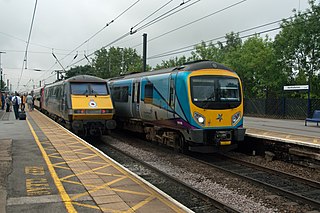
Malton railway station is a Grade II listed station which serves the towns of Malton and Norton-on-Derwent in North Yorkshire, England. Situated on the York-Scarborough Line, it is operated by TransPennine Express, who provide all passenger train services. Once a former interchange between four lines, Malton station is now only served by trains operating between York and Scarborough.

<span class="mw-page-title-main">Ampleforth</span> Village and civil parish in North Yorkshire, England

Ampleforth is a village and civil parish in North Yorkshire, England, 20 miles (32 km) north of York. The village is situated on the edge of the North York Moors National Park. The parish has a population of 883 according to the 2001 census, increasing to 1,345 at the 2011 Census, and includes Ampleforth College. The name Ampleforth means "the ford where the sorrel grows".

<span class="mw-page-title-main">Pickering railway station</span> Heritage railway station in North Yorkshire, England

Pickering railway station is the southern terminus of the North Yorkshire Moors Railway and serves the town of Pickering in North Yorkshire, England. The first railway arrived in Pickering from the north in 1836, however, it wasn't until the railway was connected from the south in 1845, that the current station was built. The station was closed by British Railways in March 1965, but since 1975, the station has served as the southern terminus of the North York Moors Railway.

<span class="mw-page-title-main">Gilling East</span> Village and civil parish in North Yorkshire, England

Gilling East is a village and civil parish in North Yorkshire, England, on the main B1363 road between York and Helmsley, 2 miles (3.2 km) south of Oswaldkirk and 5 miles (8 km) south of Helmsley. It is named "East" to distinguish it from Gilling West near Richmond, some 32 miles (51 km) away. It had a population of 321 at the 2001 Census, which had risen to 345 at the 2011 census. In 2015, North Yorkshire County Council estimated the population to be 360. The village lies in the Howardian Hills just south of the North York Moors National Park and close to Ampleforth Abbey and College.

<span class="mw-page-title-main">Rillington railway station</span> Disused railway station in North Yorkshire, England

Rillington railway station was a railway station serving the village of Rillington in North Yorkshire, England and on the York to Scarborough Line. It was also the junction station for the line to Whitby and was opened on 5 July 1845 by the York and North Midland Railway. It closed to normal passenger traffic on 22 September 1930, but was used by special trains until the 1960s. The goods yard was closed on 10 August 1964. The station building has been converted to a private house but the remainder of the station has now been demolished.

<span class="mw-page-title-main">A170 road</span> Road in North Yorkshire, England

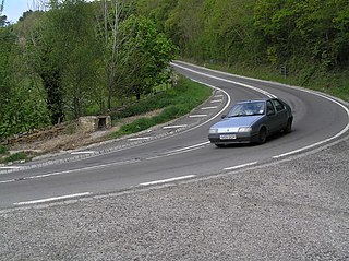
The A170 is an A road in North Yorkshire, England that links Thirsk with Scarborough through Hambleton, Helmsley, Kirkbysmoorside, Pickering. The road is 47 miles (76 km); a single carriageway for almost its totality.

<span class="mw-page-title-main">Malton and Driffield Junction Railway</span> Disused railway in Yorkshire, England

The Malton and Driffield Junction Railway, later known as the Malton and Driffield branch was a railway line in Yorkshire that ran between the towns of Malton, North Yorkshire and Driffield in the East Riding of Yorkshire.

<span class="mw-page-title-main">York and North Midland Railway</span> Former English railway company

The York and North Midland Railway (Y&NMR) was an English railway company that opened in 1839 connecting York with the Leeds and Selby Railway, and in 1840 extended this line to meet the North Midland Railway at Normanton near Leeds. Its first chairman was the railway financier George Hudson, who had been called the railway king.

<span class="mw-page-title-main">Whitby, Redcar and Middlesbrough Union Railway</span> Former railway line in Yorkshire, England

The Whitby, Redcar and Middlesbrough Union Railway (WRMU), a.k.a. the Whitby–Loftus Line, was a railway line in North Yorkshire, England, built between 1871 and 1886, running from Loftus on the Yorkshire coast to the Esk at Whitby, and connecting Middlesbrough to Whitby along the coast.

<span class="mw-page-title-main">Whitby West Cliff railway station</span> Former railway station in the North Riding of Yorkshire, England

Whitby West Cliff railway station was a railway station on the Whitby Redcar and Middlesbrough Union Railway. It was opened on 3 December 1883, to serve the West Cliff area of the town of Whitby, North Yorkshire, England. It was one of two stations serving Whitby; the other was Whitby Town railway station, which served the lines to Malton and Battersby.

<span class="mw-page-title-main">Guisborough railway station</span> Disused railway station in North Yorkshire, England

Guisborough railway station was the terminus of the Middlesbrough and Guisborough Railway. It served the town of Guisborough in North Yorkshire, England. The station was opened to goods in November 1853, and to passenger traffic on 25 February 1854. The station was closed to passengers, along with the entire Nunthorpe–Guisborough branch, on 2 March 1964, with freight being lost in August 1964.

<span class="mw-page-title-main">Helmsley railway station</span> Disused railway station in North Yorkshire, England

Helmsley railway station served the market town of Helmsley in North Yorkshire from 1871 until 1964, although the regular passenger service ceased in 1953. Helmsley station was nearly 15 miles (24 km) from Pilmoor station on the East Coast Main Line, and 12 miles (19 km) from Pickering.

<span class="mw-page-title-main">Gilling railway station</span> Disused railway station in North Yorkshire, England

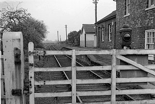
Gilling railway station is a disused railway station in North Yorkshire, England that served the village of Gilling East. East of it, the Gilling and Pickering line branched off the Thirsk and Malton line.

<span class="mw-page-title-main">Ampleforth railway station</span> Disused railway station in North Yorkshire, England

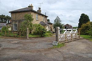
Ampleforth railway station, served the village of Ampleforth, in the Northern English county of North Yorkshire. It was located on a line which ran from Pickering to the East Coast Main Line at Thirsk. The station was close to the noted Ampleforth College although passengers for the college used the station at Gilling further east as this was more convenient for onward transfer to the college.

<span class="mw-page-title-main">Husthwaite Gate railway station</span> Disused railway station in North Yorkshire, England

Husthwaite Gate railway station is a disused railway station in North Yorkshire, England. It served the nearby village of Husthwaite.

<span class="mw-page-title-main">Pilmoor, Boroughbridge and Knaresborough Railway</span> Disused railway line in Yorkshire, England

The Pilmoor, Boroughbridge and Knaresborough Railway was a railway line in North Yorkshire, England, that connected Pilmoor on the East Coast Main Line with the towns of Boroughbridge and Knaresborough. The first part of the branch headed south-westwards from the East Coast Main Line and terminated at Boroughbridge. In 1875, the branch was extended again to meet the line at Knaresborough.

<span class="mw-page-title-main">Pilmoor railway station</span> Disused railway station in North Yorkshire, England

Pilmoor railway station was in North Yorkshire, England, from 1847 to 1958, at the junction of the Great North of England Railway and the Pilmoor, Boroughbridge and Knaresborough Railway, about 6 miles (10 km) south-southeast of Thirsk at the southern edge of the civil parish of Sessay. The scattered settlement of Pilmoor, from which its name was derived, is located southwest of it.

<span class="mw-page-title-main">Barton le Street railway station</span> Disused railway station in North Yorkshire, England

Barton le Street railway station, served the village of Barton le Street, in North Yorkshire, England. It was located on the Thirsk and Malton railway line which ran between the two towns.

<span class="mw-page-title-main">Gilling and Pickering line</span> Former railway line in Yorkshire, England

The Gilling and Pickering line (G&P) was a railway line that ran from Gilling to Pickering in North Yorkshire, England.

<span class="mw-page-title-main">Railways in Northallerton</span> About the railways in Northallerton, North Yorkshire, England

The network of railways in Northallerton, North Yorkshire, England, was constructed by three companies whose lines through the town were built between 1841 and 1852. They were all amalgamated into the North Eastern Railway (NER) which in turn was subsumed into the London and North Eastern Railway in 1923 and British Rail in 1948. British Rail closed two lines, the Wensleydale line in 1954 and a section of the Leeds Northern Railway to Harrogate in 1969. The Wensleydale line was retained as a freight branch and resurrected as a heritage railway in 2003 but the line to Harrogate closed completely. Despite closures and rationalisation, the station still is at a major junction on the East Coast Main Line.

References

  1. Suggitt 2005, p. 97.
  2. Suggitt 2005, p. 99.
  3. Suggitt 2005, p. 96.
  4. "In detail". Yorkshire Wolds Railway. Retrieved 15 August 2016.
  5. 1 2 3 4 Hoole 1974, p. 89.
  6. Chapman 2008, p. 5.
  7. Howat 2004, p. 112.
  8. "From City to Seaside". Rail Magazine. No. 491. EMAP Active. 7 July 2004. p. 45. ISSN   0953-4563.
  9. 1 2 Howat 1988, p. 3.
  10. Chapman 2008, p. 104.
  11. 1 2 Howat 1988, p. 16.
  12. 1 2 Hoole 1983, p. 14.
  13. Howat 1988, p. 22.
  14. Burgess 2011, p. 14.
  15. 1 2 Suggitt 2005, p. 98.
  16. 1 2 3 Hoole 1983, p. 15.
  17. "Bradshaws Guide for Great Britain & Ireland no 1328: 1944". Internet Archive. Bradshaws. p. 979. Retrieved 15 August 2016.
  18. Howat 1988, p. i.
  19. Reed, Des (18 November 2010). "Tales of the railway awaken memories". Gazette & Herald. Retrieved 15 August 2016.
  20. Burgess 2011, p. 16.
  21. Howat 1988, p. 48.
  22. 1 2 Howat 1988, p. 9.
  23. Howat 1988, p. 11.
  24. 1 2 Catford, Nick. "Gilling". Disused Stations. Retrieved 13 August 2016.
  25. Howat 1988, p. 13.
  26. Howat 1988, p. 18.
  27. Howat 1988, p. 20.
  28. Chapman 2008, p. 8.
  29. Burgess 2011, p. 20.
  30. Hoole 1977, p. 6.
  31. Hoole 1977, p. 55.
  32. Howat 1988, p. 12.
  33. "Accident Returns: Extract for the Accident at Ampleforth on 30th December 1865" (PDF). Railways Archive. Retrieved 13 August 2016.
  34. Catford, Nick. "Ampleforth". Disused Stations. Retrieved 15 August 2016.
  35. Catford, Nick. "Coxwold". Disused Stations. Retrieved 15 August 2016.
  36. "Slingsby country walk". Gazette & Herald. 7 October 2009. Retrieved 13 August 2016.

Bibliography