
Queensbury is a village in the metropolitan borough and city of Bradford, West Yorkshire, England. Perched on a high vantage point above Halifax, Clayton and Thornton and overlooking Bradford, Queensbury is one of the highest parishes in England, with views beyond the West Yorkshire conurbation to the hills of Brontë Country and the Yorkshire Dales to the north and north west. Its population of 8,718 in 2001 increased to 16,273 in the 2011 Census.
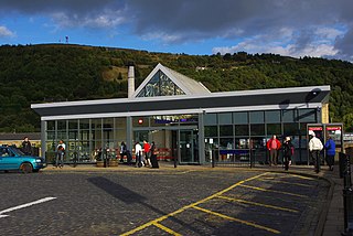
Halifax railway station serves the town of Halifax in West Yorkshire, England. It lies on the Calder Valley line and is 17 miles (27 km) west from Leeds.
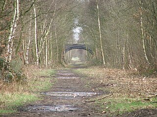
The Queensbury lines was the name given to a number of railway lines in West Yorkshire, England, that linked Bradford, Halifax and Keighley via Queensbury. All the lines were either solely owned by the Great Northern Railway (GNR) or jointly by the GNR and the Lancashire and Yorkshire Railway (L&YR). The terrain was extremely challenging for railway construction, and the lines were very expensive to build. The lines were

Queensbury railway station was a station on the Queensbury lines serving the village of Queensbury, West Yorkshire, England. The station was unusual due to its triangular shape, and at its opening the only other examples of this arrangement were Ambergate station in Derbyshire and Earlestown in Lancashire; since then Shipley station, also in West Yorkshire, has gained platforms on all three sides. Of the stations on the Queensbury lines, this was the most ambitious.
Holmfield railway station is a closed railway station that served the village of Holmfield in Halifax, West Yorkshire, England.

St Dunstans railway station is a closed station in the city of Bradford, West Yorkshire, England. The station was the location of a three-way junction with platforms on two of the lines.

Bradford Exchange railway station served the city of Bradford, West Riding of Yorkshire, England, from 1850 to 1973, before being replaced by a smaller, new-build station, which was later called Bradford Interchange. Railway lines from Halifax, Queensbury, Wakefield and Leeds met south of the city centre with services terminating in the station. In the British Rail era, many services did not terminate at Exchange station but became through services which reversed in the station to carry on their journey. Exchange station was originally opened in 1850 by the Lancashire & Yorkshire Railway (L&YR) as Drake Street, becoming Exchange in April 1867 with the arrival of services from the Great Northern Railway (GNR).

Wilsden railway station was a station on the Queensbury Lines which ran between Keighley, Bradford and Halifax.

Thornton railway station was a station on the Keighley-Queensbury section of the Queensbury Lines which ran between Keighley, Bradford and Halifax via Queensbury. The station served the village of Thornton, West Yorkshire, England from 1878 to 1955.
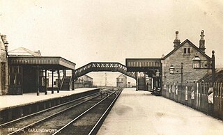
Cullingworth railway station was a station on the Queensbury Lines which ran between Keighley, Bradford and Halifax. The station served the village of Cullingworth, West Yorkshire, England. It opened for passengers in 1884 and closed in May 1955. Goods traffic continued until 1963, when the surviving line closed completely.
Great Horton railway station was a railway station on the Queensbury-Bradford section of the Queensbury Lines which ran between Bradford, Keighley and Halifax via Queensbury. The station opened for passengers in 1878 and closed on 23 May 1955 but remained open to goods with full staff until 28 June 1965 before it was closed, then demolished and the branch line tracks ripped up.
Woodside Viaduct was a railway bridge in Halifax, West Yorkshire, England. It had six arches and was situated between Woodside Tunnel and Lee Bank Tunnel. The bridge carried the Queensbury to Halifax section of the Queensbury lines.

The Harrogate–Church Fenton line was a railway line in North Yorkshire, opened by the York and North Midland Railway between 1847 and 1848, linking Harrogate and Church Fenton.
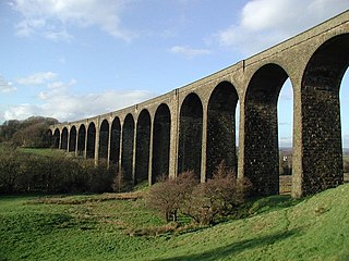
Hewenden Viaduct, situated near Cullingworth, West Yorkshire, England, originally served as a railway viaduct along the Queensbury Lines. Being one of the highest viaducts in Britain, it has been recognised as a Grade II listed structure.
The Shipley Great Northern Railway branch line was a railway line that ran east, south and then westwards from Shipley to Bradford in West Yorkshire, England. The route was opened in 1874 to goods traffic and then to passengers in 1875 by the Great Northern Railway (GNR) and looped around the eastern edge of Bradford. The GNR arrived after other railways had been established in the West Yorkshire area and many of their lines were heavily reliant on tunnels and grand viaducts, the Shipley and Windhill line being an exception to this, although it did have some steep gradients. The branch extended for 8.5 miles (13.7 km) between the two terminuses of Shipley Windhill and Bradford Exchange. The route as built from Laisterdyke to Shipley was actually only 6.5 miles (10.5 km) as the initial section from Bradford Exchange to Laisterdyke was already in existence as part of the Great Northern Railway's line to Leeds.

Lees Moor Tunnel is an abandoned tunnel on the former Great Northern Railway line between Queensbury and Keighley in West Yorkshire, England. The former dual track tunnel is just north of the village of Cullingworth in West Yorkshire and when built was 1,533 yards (1,402 m) long. Due to the pitch black inside and the squealing of the wheels on the 1 in 50 radius curve, drivers nicknamed it the 'Hell Hole'. After closure to passengers, the tunnel was used in experiments involving the effects of smoke inhalation and cancer.

The Great Northern Railway Trail is a cycleway and footpath in the Bradford District of West Yorkshire, England. The path follows the route of a former railway, that of the Great Northern railway line between Bradford and Keighley that went via Queensbury and Cullingworth. The path has been designated as part of the National Cycle Route number 69.

The Spen Valley Line was a railway that connected Mirfield with Low Moor through the Spen Valley in West Yorkshire, England. Opened up by the Lancashire and Yorkshire Railway in 1847, with full opening to Low Moor in 1848, the line served a busy industrial and textile area and allowed a connection for trains between Huddersfield and Bradford. The line was absorbed by the London & North Western Railway, the London Midland and Scottish Railway (LMS) and British Railways on Nationalisation. A separate link between Heckmondwike Central and Thornhill that opened later and was known as the Ravensthorpe Branch, allowed through running to Wakefield and beyond. The line was closed down to passengers in 1965 with freight continuing sporadically until 1981. A Spur onto the former Leeds New Line from the Ravensthorpe Branch kept the very southern end open until the late 1980s. The majority of the route is now the Spen Valley Greenway cycle path.

The Apperley Viaducts are two adjacent railway viaducts straddling the River Aire in West Yorkshire, England. The open viaduct dates back to 1900, carrying the current double track Airedale line railway, whereas the redundant adjacent viaduct dates back to 1867, and was built to replace the original bridge at this point which collapsed in November 1866 due to severe flooding. The viaducts are two of the many railway crossings of the River Aire between Shipley and Leeds.
The Royston to Thornhill line was a Midland Railway venture constructed in West Yorkshire, England, that had the intent to allow trains to travel from Sheffield to Bradford without going through Leeds. The scheme, which was promoted as the West Riding Lines, would have travelled underneath Bradford city centre in a long tunnel and ended up in the Aire Valley providing a through line across Bradford. In the event, only the section from Royston to Thornhill, a smaller branch to a goods station at Dewsbury Savile Town, and a longer branch from Mirfield to Huddersfield were ever built. By the late 1960s, the lines had all been closed, however, the viaducts at Bradley, Crigglestone, and Horbury still remain.

