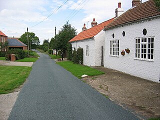
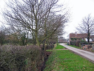
Aike is a hamlet and former civil parish, now in the parish of Lockington, in the East Riding of Yorkshire, England. The hamlet is centred around a single developed street, which lies to the east of the Yorkshire Wolds. Aike is approximately 4 miles (6 km) north of Beverley and approximately 0.4 miles (1 km) from the west bank of the River Hull. It is approached by a 2.5-mile (4 km) lane which is a no-through road that does not continue beyond the village, although a farm track continues as far as a bridge across the Beverley and Barmston Drain. In 1931 the parish had a population of 48.

The A165 is a road that links Scarborough and Kingston upon Hull, both in Yorkshire, England. The road is designated as a Primary Route from its junction with the A64 in Scarborough to its southern terminus in Hull.

Long Riston is a village in the civil parish of Riston, in the East Riding of Yorkshire, England, in an area known as Holderness. It is situated approximately 9 miles (14 km) north of Kingston upon Hull city centre and 6 miles (10 km) east of Beverley town centre. It lies to the east of the A165 road which by-passes the village. In 1931 the parish had a population of 266. On 1 April 1935 the parish was abolished to form Riston.

Snaith is a market town in the East Riding of Yorkshire, England, close to the River Aire and the M62 and M18 motorways, 7 miles (11 km) west of Goole, 10 miles (16 km) east of Knottingley, 8 miles (13 km) south of Selby, 10 miles (16 km) southwest of Howden and 8 miles (13 km) northwest of Thorne.

North Rigton is a village and civil parish in the Harrogate district of North Yorkshire, England. It is 2 miles (3 km) south of Harrogate. The population of the parish was 460 in 2011. Almscliffe Crag adjacent to the village was used for scenery at the end of Yorkshire Television dramas, The Beiderbecke Affair, The Beiderbecke Tapes and The Beiderbecke Connection. The area was never referred to by name.
Thirtleby is a hamlet in the civil parish of Coniston, in the East Riding of Yorkshire, England. It is situated approximately 6 miles (9.7 km) north-east of Hull city centre and 1 mile (1.6 km) west of the village of Sproatley.

South Newbald is a hamlet and former civil parish, now in the parish of Newbald, in the East Riding of Yorkshire, England. It is situated approximately 12 miles (19 km) north-west of Hull city centre, 2.5 miles (4 km) north of South Cave and 4 miles (6.4 km) south of Market Weighton. It lies to the east of the A1034 road. The larger village of North Newbald is just to the north. In 1931 the parish had a population of 173.
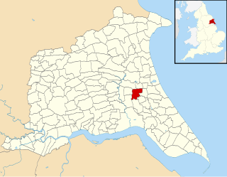
Riston is a civil parish in the East Riding of Yorkshire, England. It is situated approximately 9 miles (14 km) north of Hull city centre and covering an area of 1,374.241 hectares.

Gardham or Low Gardham is a small hamlet in the East Riding of Yorkshire, England. It is situated approximately 5 miles (8 km) west of Beverley town centre and 2 miles (3.2 km) west of the village of Cherry Burton. 1.5 miles (2.4 km) to the north-east lies Etton.

High Gardham is a small hamlet in the East Riding of Yorkshire, England. It is situated approximately 5.5 miles (9 km) west of Beverley town centre and 3 miles (5 km) west of the village of Cherry Burton. It lies to the south of the A1079 road.

Little Catwick is a hamlet in the East Riding of Yorkshire, England. It is situated approximately 7 miles (11 km) north-east of Beverley town centre. It lies 0.5 miles (0.8 km) east of the A165 Leven by-pass.
Kirby Underdale is a village and civil parish in the East Riding of Yorkshire, England. It is situated approximately six miles north of Pocklington town centre and lies one mile north of the main A166 road from York to Driffield.

Etton is a village and civil parish in the East Riding of Yorkshire, England. It is situated approximately 4 miles (6 km) north-west of Beverley town centre and 2 miles (3.2 km) west of the village of Leconfield. 1 mile (1.6 km) to the south-east is Cherry Burton. To the west lie the hamlets of Kiplingcotes and Gardham. South Dalton lies 1.5 miles to the north-west.
Balkholme is a hamlet and former civil parish, now in the parish of Kilpin and the East Riding of Yorkshire, England. In 1931 the parish had a population of 78.

Hempholme is a hamlet in the civil parish of Brandesburton, in Holderness, in the East Riding of Yorkshire, England. It is situated approximately 8 miles (13 km) north-east of Beverley town centre, and 1 mile (1.6 km) east of the Driffield Navigation.

Gowthorpe is a hamlet in the East Riding of Yorkshire, England. It is situated approximately 4 miles (6 km) north-west of Pocklington town centre and 3 miles (5 km) east of the village of Stamford Bridge.
Fimber is a village and civil parish in the East Riding of Yorkshire, England. It is situated approximately 8 miles (13 km) north-west of Driffield town centre and 3 miles (5 km) south-west of the village of Sledmere. It lies on the B1248 road. The civil parish is formed by the village of Fimber and the hamlet of Towthorpe. According to the 2001 UK Census, Fimber parish had a population of 91.

Everthorpe is a hamlet in the East Riding of Yorkshire, England. It is situated approximately 11 miles (18 km) west of Hull city centre and 10 miles (16 km) east of the market town of Howden, midway between North Cave and South Cave. It lies 1 mile (1.6 km) north of the A63 road and 1 mile west of the A1034 road. Everthorpe forms part of the civil parish of North Cave.

Etherdwick is a hamlet in the East Riding of Yorkshire, England in an area known as Holderness. It is approximately 9 miles (14 km) north-west of Withernsea town centre. It lies 1.5 miles (2.4 km) to the west of the B1242 road.

Coniston is a village and civil parish in the East Riding of Yorkshire, England, in an area known as Holderness. It is situated approximately 6 miles (10 km) north-east of Hull city centre and less than 1 mile (1.6 km) north-east of the village of Ganstead. It lies on the A165 road.

