
Arusha City is a Tanzanian city, with a population of 617,631, and the regional capital of the Arusha Region, with a population of 2,356,255.

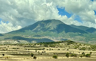
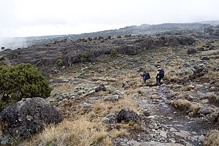
Mount Meru is a dormant stratovolcano located 70 kilometres (43 mi) west of Kilimanjaro in southeast Arusha Region, Tanzania. At a height of 4,562.13 metres (14,968 ft), it is visible from Mount Kilimanjaro on a clear day, and is the fifth-highest of the highest mountain peaks of Africa, dependent on definition.

Singida Region is one of Tanzania's 31 administrative regions. The region covers a land area of 49,340 km2 (19,050 sq mi). The region is comparable in size to the combined land area of the nation state of Slovakia. The Region is bordered to the north by Shinyanga Region, Simiyu Region and Arusha Region, to the northeast by Manyara Region, to the east by Dodoma Region, to the southeast by Iringa Region, to the southwest by Mbeya Region and to the west by Tabora Region. The regional capital is the municipality of Singida. According to the 2022 national census, the region had a population of 2,008,058.
Manyara Region is one of Tanzania's 31 administrative regions. The regional capital is the town of Babati. According to the 2012 national census, the region had a population of 1,425,131, which was lower than the pre-census projection of 1,497,555. For 2002–2012, the region's 3.2 percent average annual population growth rate was tied for the third highest in the country. It was also the 22nd most densely populated region with 32 people per square kilometre.
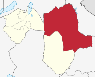
Arusha Region is one of Tanzania's 31 administrative regions and is located in the northeast of the country. The region's capital and largest city is the city of Arusha. The region is bordered by Kajiado County and Narok County in Kenya to the north, the Kilimanjaro Region to the east, the Manyara and Singida Regions to the south, and the Mara and Simiyu regions to the west. Arusha Region is home to Ngorongoro Conservation Area, a UNESCO World Heritage Site. The region is comparable in size to the combined land and water areas of the state of Maryland in the United States.

'Monduli District is one of seven districts of the Arusha Region of Tanzania. It is bordered to the north by Longido District, to the east by Arusha Rural District, to the south by the Manyara Region and to the west by Ngorongoro District and Karatu District. The District covers an area of 6,993 km2 (2,700 sq mi). The town of Monduli is the administrative seat of the district. According to the 2002 Tanzania National Census, the population of the Monduli District was 185,237. By 2012, the population of the district was 158,929. By 2022, the population had grown to 227,585.

Karatu District is one of seven districts of the Arusha Region of Tanzania. The district is bordered to the north by the Ngorongoro District and to the west by the Meatu District in the Simiyu Region. The district is bordered to the east by the Monduli District, and to the south and southeast by the Mbulu District and the Babati District. The district covers an area of 3,207 km2 (1,238 sq mi). The district is comparable in size to the land area of Samoa. The district has an max elevation of 1,739 m (5,705 ft) on Oldeani Peak. Karatu district is home to the hunter-gatherer community of the Hadza people. Also Karatu is known agriculturally as the onion capital of Tanzania. The district capital is the town of Karatu. According to the 2022 census, the population of the district was 280,454.
Arusha City Council is one of seven administrative districts of Arusha Region in Tanzania. It is surrounded to the south, west and north by Arusha Rural District and to east by Meru District. The district covers an area of 267.0 km2 (103.1 sq mi). The district is comparable in size to the land area of Cayman Islands. The district capital is the city of Arusha. As of 1994, Arusha District was the wealthiest district in Tanzania. According to the 2022 Tanzania National Census, the population of Arusha Urban District was 617,631.

Arumeru District is a former district in the Arusha Region of Tanzania. It was bordered to the north, west, and southwest by Monduli District, to the southeast by the city of Arusha, and to the east by the Kilimanjaro Region.

Hai is one of the seven districts of the Kilimanjaro Region of Tanzania.The district covers approximately 1,217 square kilometres (470 sq mi). It is bordered to the southwest by the Meru District of Arusha Region, to the west by the Siha District, and to the east by the Moshi Urban District and Moshi Rural District and the Rombo District to the far north. The western breach part of Mount Kilimanjaro is located in the Hai District. According to the 2022 census, the population of the Hai District was 240,999.
Simanjiro District is one of the six districts of the Manyara Region of Tanzania. It is bordered to the north by Arusha Region, to the north east by Kilimanjaro Region, to the south east by Tanga Region, to the south by Kiteto District, to the south west by Dodoma Region and to the west by Babati Rural District. The district headquarters are located in Orkesumet. According to the 2022 Tanzania National Census, the population of Simanjro District was 291,169. Simanjiro District is endowed with gemstones, being the only location on the planet that has tanzanite. Simanjiro was also where the first tsavolite was discovered.

Usa River also known locally as Ussa is an administrative ward of the Meru District in the Arusha Region of Tanzania. It is the seat of Meru District. To the north and west, the ward is surrounded by the wards of Nkoaranga, Poli, and Seela Sing'isi. To the south and east, respectively, are the wards of Kikwe and Maroroni, and Maji ya Chai. As of 2012, Usa River ward had a population of 23,437.

The Arusha people are a Bantu ethnic and indigenous group based in the western slopes of mount Meru in Arusha District of Arusha Region in Tanzania. The Maasai regard the Arusha people as related as they were once a part of the immigrant Maasai whom arrived in Arusha in the late 18th century from Kenya. The Arusha people are not to be confused by Arusha residents who are a mix of people of different ethnic backgrounds that are born and reside within the borders of the Arusha Region.

Meru District, officially the Meru District Council is one of seven districts of the Arusha Region of Tanzania.The District is bordered to the north by Longido District, to the east by Siha and Hai Districts of Kilimanjaro Region, to the south by Simanjiro District of Manyara Region, and to the west by Arusha Rural District and Arusha Urban District. It covers an area of 1,266 km2 (489 sq mi). The district is comparable in size to the land area of Faroe Islands. Meru District has an max elevation of 3,800 m (12,500 ft) at Rhino Point on Mount Meru. The administrative capital of the district is Usa River. According to the 2022 Tanzania National Census, the population of Meru District council was 331,603.
Kisongo is an administrative ward and small town in the Arusha Rural District of the Arusha Region of Tanzania. According to the 2022 census, the ward has a total population of 12,519. It is located in the outskirts of Arusha, about 7 km west of Arusha Airport. The word Kisongo comes from one of the four major Masai Clan families, Kiputiei, Loitai, Purko and Kisongo.
Mateves is a Tanzanian administrative ward located in Arusha Rural District of the Arusha Region. It is one of 21 administrative wards in the district. Mateves means places where the fever tree grows in the Maasai language. Mateves ward is bordered by Musa ward to the northwest, Oltrumet ward to the far northeast, a tip of the Olorieni ward to the northeast as well. Olasiti ward borders Mateves to the north east and Terrat to the south east. To the south of Mateves is Oljoro ward and the southwest of Mateves is the Moita Ward and lastly, towards the west is Kisongo ward. The small town of Ngorbob is the seat of the ward. The ward is home to the Mungu Crater and Loljoro Hill at 1,585 meters. The ward covers an area of 104.4 km2 (40.3 sq mi), and has an elevation of 1,328 m (4,357 ft). According to the 2012 census, the ward had a total population of 15,632

Sekei is an administrative ward and district capital located in the Arusha City Council of Arusha Region in Tanzania. The ward is bordered by Kaloleni ward to the west, Sokon II ward to the north, Kimandolu ward to the east, Themi to the south and, a tiny portion of Kati ward to the southeast. The name sekei comes from the Masai word seki which is a type of tree that grew there before settlement. Sekei ward was officially established in 1969 and is the location of the headquarters of Arusha City Council.

Longido District is one of seven districts of the Arusha Region of Tanzania. The district is bordered to the east by the Ngorongoro District, to the south west by the Monduli District and southeast by the Arusha Rural District and Meru District. To the far east by Siha District of Kilimanjaro Region and the north by Kenya. It covers an area of 7,885 km2 (3,044 sq mi). The district is comparable in size to the land area of Puerto Rico.Longido District was created in 2007 from Monduli District. Mount Longido, Gelai and Kitumbeine volcano are all located within the boundaries of the district. The administrative seat is the town of Longido. According to the 2022 census, the population of the district was 175,915. Longido District is known as Arusha's gem district, as it is home to Anyolite and Rubies.
Siha is one of the seven administrative districts of Kilimanjaro Region in Tanzania. The district covers approximately 1,217 square kilometres (470 sq mi). It is bordered to the west by Meru District in Arusha Region and to the northeast by Rombo District and the southeast Hai District. The western part of Mount Kilimanjaro is located within the district's boundaries.

Sokon II is one of the 27 administrative wards of the Arusha District Council located in the Arusha Region of Tanzania. The name Sokon comes from the Swahili word for market, sokoni. The ward shares a similar name with another ward located in Arusha Urban District called Sokon I and the former is one of 27 rural administrative wards in the district as of 2012. Sokon II ward is bordered by Oltoroto and Moivo ward in the west, Ilkiding'a ward to the north, Bangata ward to the east. On the southern border Sokon II is bordered by Baraa, Kimandolu and Sekei wards. According to the 2012 census, the ward has a total population of 32,073. Thus, Sokon II is the most populous ward in Arusha District. Also the ward headquarters are Oldadai village. In addition, the Arusha District Administration building is located in Sokon II ward.


