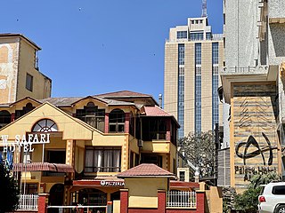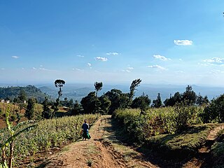
Arusha City is a Tanzanian city and the regional capital of the Arusha Region, with a population of 416,442 plus 323,198 in the surrounding Arusha Rural District. Located below Mount Meru on the eastern edge of the eastern branch of the Great Rift Valley, Arusha City has a temperate climate. The city is close to the Serengeti National Park, the Ngorongoro Conservation Area, Lake Manyara National Park, Olduvai Gorge, Tarangire National Park, Mount Kilimanjaro, and Mount Meru in the Arusha National Park and is thus considered the safari capital of the world.

Mount Meru is a dormant stratovolcano located 70 kilometres (43 mi) west of Mount Kilimanjaro in southeast Arusha Region, Tanzania. At a height of 4,562.13 metres (14,968 ft), it is visible from Mount Kilimanjaro on a clear day, and is the fifth-highest of the highest mountain peaks of Africa, dependent on definition.

Arusha Region is one of Tanzania's 31 administrative regions and is located in the north of the country. The region's capital and largest city is the city of Arusha. The region is bordered by Kajiado County and Narok County in Kenya to the north, the Kilimanjaro Region to the east, the Manyara and Singida Regions to the south, and the Mara and Simiyu regions to the west. Arusha Region is home to Ngorongoro Conservation Area, a UNESCO World Heritage Site. The region is comparable in size to the combined land and water areas of the state of Maryland in the United States.

Arusha National Park covers Mount Meru, a prominent volcano with an elevation of 4566 m, in the Arusha Region of north eastern Tanzania. The park is small but varied with spectacular landscapes in three distinct areas. In the west, the Meru Crater funnels the Jekukumia River; the peak of Mount Meru lies on its rim. Ngurdoto Crater in the south-east is grassland. The shallow alkaline Momella Lakes in the north-east have varying algal colours and are known for their wading birds.

Monduli is one of the seven districts of the Arusha Region of Tanzania. The District covers an area of 6,993 km2 (2,700 sq mi). It is bordered to the north by Longido District, to the east by Arusha Rural District, to the south by the Manyara Region and to the west by Ngorongoro District and Karatu District. The town of Monduli is the administrative seat of the district. According to the 2002 Tanzania National Census, the population of the Monduli District was 185,237. By 2012, the population of the district was 158,929.

Arusha Urban District is one of the seven districts of the Arusha Region of Tanzania, and it contains the regional and economic capital; the city of Arusha. It is bordered to the south, west and north by Arusha Rural District and to east by Meru District. As of 1994, Arusha District was the wealthiest district in Tanzania with TSh 91,024/=. According to the 2012 Tanzania National Census, the population of Arusha Urban District was 416,442.

Arumeru District is a former district in the Arusha Region of Tanzania. It was bordered to the north, west, and southwest by Monduli District, to the southeast by the city of Arusha, and to the east by the Kilimanjaro Region.
Usa River or Usaa River is a town and ward around 23 kilometres (14 mi) to the east of the City of Arusha, the capital of the Arusha Region of northern Tanzania. Usa River is the district capital of Meru District. As of 2012, Usa River ward had a population of 23,437.

The Arusha people are a Bantu ethnic and indigenous group based in the western slopes of mount Meru in Arusha District of Arusha Region in Tanzania. The Maasai regard the Arusha people as related as they were once a part of the immigrant Maasai society that arrived in Arusha in the 18th century from Kenya. The Arusha people are not to be confused by Arusha residents who are Tanzanian people of different ethnic backgrounds that are born and reside within the borders of the Arusha Region.
Makumira is a small town located in Poli ward of Meru District in Arusha Region of northern Tanzania. It lies on the slope of Mount Meru, the fifth-highest mountain in Africa. Makumira is about 16 kilometres from the city of Arusha on the main road, A23. The neighboring villages are Tengeru and Usa River.

Meru or Meru District Council is one of the seven districts councils of the Arusha Region of Tanzania.The District covers an area of 1,266 km2 (489 sq mi). and has an max elevation of 3,800 m (12,500 ft). Meru District is bordered to the north by Longido District, to the east by Siha and Hai Districts of Kilimanjaro Region, to the south by Simanjiro District of Manyara Region, and to the west by Arusha Rural District and Arusha Urban District. The administrative capital of the council is Usa River.
Leguruki is an administrative ward in the Meru District of the Arusha Region of Tanzania. The ward is home to ober 60 small lakes and is the lake ward of Meru district and also home to the eastern section of Arusha National Park. The ward is bordered to the east by Siha Distric of Kilimanjaro Region. According to the 2002 census, the ward has a total population of 15,678.
Maji ya Chai is an administrative ward in the Meru District of the Arusha Region of Tanzania. The ward is home to the University of Arusha is also where the gate of Arusha National Park is located. According to the 2012 census, the ward has a total population of 29,313. Thus making the ward the most populous in Meru district.
Nduruma, is a administrative ward in Arusha Rural District in the east Arusha Region of Tanzania. It is bordered to the north by Mlangarini, to the south by Bwawani, and to the east by Kikwe ward of the Meru District. The ward covers an area of 62.72 square kilometres (24.22 sq mi) with an average elevation of 1,041 metres (3,415 ft).
Kimandolu is an administrative ward in the Arusha District of the Arusha Region of Tanzania. It is roughly 6 km from the centre of Arusha town and lies between the Old Moshi Road and the Arusha-Himo highway, which leads directly to Moshi and Kilimanjaro International Airport. There are various charitable NGOs currently working in the area with schools, healthcare and sports, such as Art In Tanzania. The local representative is Jackson Lemunga.

Longido is one of the six districts in the Arusha Region of Tanzania. The District covers an area of 7,885 km2 (3,044 sq mi). It is bordered to the east by the Ngorongoro District, to the south west by the Monduli District and Southeast by the Arusha Rural District and Meru District. To the far east by Siha District of Kilimanjaro Region and the north by Kenya. Longido District was created in 2007 from Monduli District. Mount Longido is located within the boundaries of the district.

The Meru, also known as the Va-Rwa, are a Bantu ethnic group native to the slopes of Mount Meru in Arusha Region. The Meru people share the same name with the Meru people of Kenya, but they are completely different ethnic groups each with their own unique history and identity.

Arusha District Council is one of the seven districts of the Arusha Region of Tanzania. It is bordered to the north by Longido District, to the east by Meru District, to the south by Kilimanjaro Region, and to the west by Monduli District. It surrounds Arusha City.


