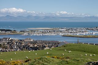
Pwllheli is a market town and community on the Llŷn Peninsula, in Gwynedd, north-west Wales. It had a population of 4,076 in 2011, which declined slightly to 3,947 in 2021; a large proportion (81%) were Welsh speaking. Pwllheli is the place where Plaid Cymru was founded. It is the birthplace of the Welsh poet Sir Albert Evans-Jones.
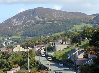
Penmaenmawr is a town and community in Conwy County Borough, Wales, which was formerly in the parish of Dwygyfylchi and the traditional county of Caernarfonshire. It is on the North Wales coast between Conwy and Llanfairfechan and was an important quarrying town, though quarrying is no longer a major employer. The population of the community was 4,353 in 2011, including Dwygyfylchi and Capelulo. The town itself having a population of 2,868 (2011).

The River Conwy is a river in north Wales. From its source to its discharge in Conwy Bay it is 55 kilometres (34 mi) long and drains an area of 678 square km. "Conwy" was formerly anglicised as "Conway."

River Neath is a river in south Wales running south west from the point at which its headwaters arising in the Brecon Beacons National Park converge to its mouth at Baglan Bay below Briton Ferry on the east side of Swansea Bay.
Ketu is the name of a Yoruba subgroup, historical kingdom and region straddling parts of what is now southeastern Republic of Benin and parts of southwest Nigeria. The chief town and traditional capital of the area was the town of Kétou (Kétu), which is considered to be one of the oldest capitals of the Yoruba-speaking people, tracing its establishment to a settlement founded by a descendant of Oduduwa called Sopasan or Soipasan. The Oba of the town were traditionally styled "Alákétu", and are related directly to Ile-Ife in present-day Nigeria. Other towns that were historically part of the Kétu Kingdom are;

The Ẹgbado, now Yewa, are a subgroup of the Yoruba people and mostly inhabit the eastern area of Ogun West Senatorial District, Ogun State, in south-west Nigeria, Africa. In 1995, the group's name was changed to Yewa after the Yewa River, the river (odo) they foraged towards. The name of this river is derived from the Yoruba goddess Yewa. Yewa/Ẹgbado mainly occupy four Local Government Areas in Ogun State, Yewa South, Yewa North, Imeko-Afon, and Ipokia, while the Ado-Odo/Ota LGA forms the fifth Awori part of the senatorial district. Other Yewa/Ẹgbado are located in Lagos West, Lagos East, Oyo North, and Oyo South senatorial zones.

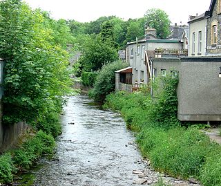
Corris is a village in the county of Gwynedd, Wales, about 4.5 miles (7 km) north of the town of Machynlleth. The village lies on the west bank of the Afon Dulas, around that river's confluence with the Afon Deri. Corris railway station is the headquarters and museum of the Corris Railway, a preserved narrow gauge railway.
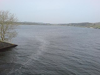
Llyn Cefni is a small reservoir in the centre of Anglesey, Wales which is managed by Welsh Water and Hamdden Ltd, while the fishery is managed by the Cefni Angling Association. The reservoir is located just 1 kilometre (0.6 mi) northwest of the island's county town of Llangefni.
The River Brenig is a tributary river of the River Teifi and runs through the market town of Tregaron in Ceredigion, Wales.
Oyigbo also known as Obigbo is a Local Government Area located in Rivers State, Nigeria. It is a town, 30 kilometers from the Port city of Port Harcourt, 25km from the city of Aba. It's predominantly inhabited by the Asa people an indigenous Igbo people who are also found in Ukwa west L.G.A in Abia state and the Ndoki people who are also found in Ukwa East L.G.A of Abia state and Ukanafun L.G.A of Akwa ibom state

Ukwa West is a Local Government Area in Abia State, Nigeria. Its headquarters is in the town of Oke Ikpe.

Imeko Afon is a Local Government Area in the west of Ogun State, Nigeria bordering the Republic of Benin. Its headquarters are in the town of Imeko at coordinates 7°29′00″N2°53′00″E.

Ìlàje is a Local Government Area in Ondo State, South-West Nigeria. Its headquarters are in the town of Igbokoda. The Ilajes are a distinct migratory coastal linguistic group of Yoruba peoples spread along the coastal belts of Ondo, Ogun, Lagos and Delta states and originally made up of four geo-political entities, namely: Ode Ugbo, Ode Mahin, Ode Etikan and Aheri. While most towns and villages in the Mahin kingdom are distributed on arable lands, the towns and villages in the other three polities of Ugbo, Aheri and Etikan kingdoms are spread out along the beaches and swampy terrain of the Atlantic Ocean coast.
Ogo Oluwa is a Local Government Area in Oyo State, Nigeria. Its headquarters are in the town of Ajaawa.

Dwygyfylchi is a village in Conwy County Borough, Wales. It is part of the community of Penmaenmawr which has a population of 4,353. The electoral ward of Capelulo which includes Dwygyfylchi had a population of 1,485 in 2011. It forms part of the historic county of Caernarfonshire.
Muktar Tolani Shagaya is a Nigerian politician and a current House of Representatives member in the 10th National Assembly, representing Ilorin West/Asa Federal Constituency since June 2023. He is the deputy chairman, House of the Representatives Committee on Basic Education & Services. Since assuming office as a member of the National Assembly, Shagaya Tolani has sponsored over 15 bills, co-sponsored several others, and introduced motions in the House of Representatives.
Bello Yinusa Oniboki is a Nigerian academician and politician representing the Afon constituency, Asa local government area in the Kwara State House of Assembly at the 10th Assembly.
Aliyu Wahab Opakunle is a Nigerian politician representing the Afon constituency, Asa local government area in the Kwara State House of Assembly.
Amosa Mohammed Mobolaji is a Nigerian politician and member of the 8th assembly representing Afon constituency the Kwara State House of Assembly.
Aboto Alfa, Kwara is an agrarian village in Asa local government Area, Kwara State, Nigeria. The postal code of the village is 240104.


