
Hurlstone Park is a suburb in the Inner West of Sydney, New South Wales, Australia. Hurlstone Park is located nine kilometres south-west of the Sydney central business district and is mostly in the local government area of the City of Canterbury-Bankstown, and partly in the Inner West Council. The suburb is bounded by: the Cooks River to the south, Garnet Street to the east, New Canterbury Road to the north, Canterbury Road to the north-west, and Church Street to the west.

Doncaster East is a suburb of Melbourne, Victoria, Australia, 20 km east of Melbourne's Central Business District, located within the City of Manningham local government area. Doncaster East recorded a population of 30,926 at the 2021 census.

Marion is a suburb in the City of Marion, around 10 kilometres (6.2 mi) south-west of the city centre of Adelaide, the capital of South Australia. Founded as a rural village in 1838 on the banks of the Sturt River, Marion was found to have rich soil and the population expanded rapidly. Colonel William Light laid out the plan for the village, as he had done with the City of Adelaide itself.
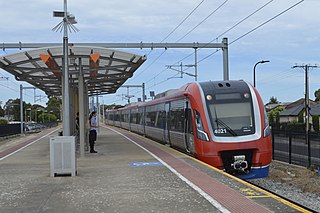
Ascot Park railway station is located on the Seaford line. Situated in the south-western Adelaide suburb of Ascot Park, it is 10.2 kilometres from Adelaide station.

Prospect is the seat of the City of Prospect and an inner northern suburb of greater Adelaide. It is located 5 km (3.1 mi) north of Adelaide's centre.
Grange is a coastal suburb of the City of Charles Sturt, in Adelaide, South Australia, located about 11 kilometres (6.8 mi) from the Adelaide city centre. The suburb is named after Captain Charles Sturt's cottage, built in 1840–41, which still stands and is now a museum. In addition to Grange Beach, the suburb has several parks and reserves, as well as the Grange Hotel, which was originally licensed in 1881.

Blair Athol is located about 6 km (4 mi) north of the Adelaide CBD, South Australia. Blair Athol borders the suburbs of Gepps Cross, Enfield, Prospect and Kilburn. The suburb is rectangular, stretching from Grand Junction Road in the north to Angwin Avenue in the south between Prospect Road on the west and Main North Road on the east. Blair Athol's main and longest street is Florence Avenue.

Clarence Park is an inner southern suburb of Adelaide, South Australia in the City of Unley. Its borders are Mills Street (north), Goodwood Road (east), Cross Road (south) and the Seaford railway line (north-west).

Black Forest is an inner southern suburb of Adelaide, South Australia. It is located in the City of Unley, bounded by the Glenelg tram line (north-west), the Seaford railway line (south-east), South Road (west) and East Avenue (east).

Millswood is an inner-southern mainly residential suburb of Adelaide in the City of Unley. It was named after Scotsman Samuel Mills, who arrived in the colony in 1839.
Plympton is an inner south-western suburb of Adelaide, South Australia. The name is believed to have been given by Henry Mooringe Boswarva to a private subdivision in the area, naming after his home town in Devon, England. It was accepted as an official name for the suburb in 1944.

Clovelly Park is an inner southern suburb of Adelaide in the local government area of the City of Marion. Before becoming an 'advanced' suburb, it was a farm and vineyard. The suburb is bordered by Daws Road to the north, South Road to the east, Sturt Road to the south, and a combination of Percy Avenue and the Flinders railway line to the west. It is situated approximately 20 minutes from the Adelaide city centre, and about 2 minutes from Flinders University, Flinders Medical Centre and Westfield Marion.
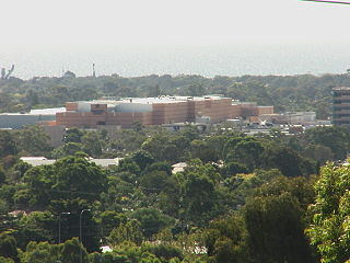
Oaklands Park is a southern suburb of Adelaide, South Australia in the City of Marion. The Marion Shopping Centre is a major feature of the suburb.

Park Holme is a south-western suburb of Adelaide in the City of Marion, South Australia, located about 8 km (5 mi) from the Adelaide city centre. It is bordered to the east by Marion Road, to the west by Hendrie Street, to the south by Oaklands Road, and to the north by Tarranna Ave, which is just south of Bray Street. It is adjacent to Ascot Park, Edwardstown, South Plympton, Mitchell Park, Clovelly Park, Glengowrie, Morphettville and Oaklands Park. Park Holme covers 115 hectares, (1.15 sq km).

Plympton Park is an inner south-western suburb of Adelaide 8 km from the CBD, in the state of South Australia and falls under the City of Marion. The post code for Plympton Park is 5038. It is adjacent to Park Holme, Plympton, South Plympton, and Morphettville. It is bordered to the east by Marion Road, to the west by Park Terrace, to the south by Taranna Avenue and to the north by the Glenelg tram line.

Goodwood Road is a major north–south arterial road, approximately 10 kilometres long, in Adelaide, South Australia. It runs between the Adelaide city centre and Adelaide's southern suburbs of Pasadena and Panorama.

Woodville North is a north-western suburb of Adelaide 10 km from the Adelaide city centre, in the state of South Australia, Australia and falls under the City of Charles Sturt. The post code for Woodville North is 5012. It is adjacent to Pennington, Athol Park, Woodville Gardens, Mansfield Park, Woodville and Kilkenny. It is bordered to the east by Hanson Road to the west by Carlton Crescent, to the south by Torrens Road and to the north by Hamilton Road. The suburb is residential, apart from an industrial pocket to the northwest.

Cross Road is a major arterial road that travels east–west through the inner southern suburbs of the Australian city of Adelaide. It is designated route A3.

Daws Road is a major arterial road in the central southern suburbs of Adelaide. It runs east–west between Marion Road in the west and Goodwood Road in the east. Pasadena High School and the Repatriation Hospital are on Daws Road.
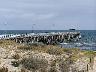
Port Noarlunga South is a suburb in the Australian state of South Australia located in the Adelaide metropolitan area on the coastline of Gulf St Vincent about 30 kilometres south of the state capital of Adelaide.
