The Asia Pacific Geoparks Network (APGN) is the regional geopark network of the Global Geoparks Network (GGN) and the UNESCO International Geosciences and Geoparks Programme (UNESCO-IGGP). Its main role is to coordinate the activities of GGN in the UNESCO regions of Asia and the Pacific, to promote networking between global geoparks and geopark professionals in the region and to provide support for sustainable economic development in geopark areas. As of 2020 February, the APGN had 60 institutional members (UNESCO Global Geoparks) in countries. [1] [2] The Pacific region is currently not represented by a global geopark, but there are ongoing geopark projects, [3] just as in other countries of Asia.
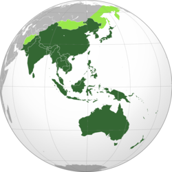
The APGN was founded in 2007 based on the proposal at the 1st Asia Pacific Geoparks Symposium in Langkawi (Malaysia). It was endorsed by GGN in 2008 and became its official regional geopark network in 2013, in compliance with its Rules of Operation. [4]
The governing bodies of the regional network as an agency are:
The personnel recognized as official members of the regional agency are:
The region only approximately follows continental guidelines. Turkey and Russia are in the European network. Iran is in the Asia Pacific. Otherwise the country distribution is Australasia.
The member states of the APGN have established national geopark networks. By UNESCO rules a geopark must first apply for membership in the national geopark network and be accredited there before it can apply to membership in the regional geopark network. Having been accredited in the latter they may apply to the global network. This bottom-up method helps to insure that the member nations organize the activities of GGN on a national level first.
National Network | Number of UNESCO Global Geoparks | Number of national geoparks | Reference |
---|---|---|---|
Chinese National Geoparks | 39 | 236 | [5] |
Indonesian National Geoparks | 4 | 15 | [6] |
Japanese National Geoparks | 9 | 35 | [7] |
Korean National Geoparks | 3 | 7 | [8] |
Malaysian National Geoparks | 2 | ||
Philippine National Geoparks | 1 | [9] | |
Thai National Geoparks | 2 | 4 | |
Vietnamese National Geoparks | 3 |
As a regional geopark network, APGN is the organizer of several workshops and seminars, capacity building activities, common projects, promotional activities, and common publications between the member countries and UNESCO Global Geoparks. Besides the regular meetings of the Advisor and Coordination Committees, the most important events of the network are the biennial symposiums, a place of exchange on research activities and management practices in geoparks.
Symposium | Venue | |
---|---|---|
1st Asia-Pacific Geoparks Network Symposium | Langkawi UGG, Malaysia | 2007 |
2nd Asia-Pacific Geoparks Network Symposium | Hanoi, Vietnam | July 2011 |
3rd Asia-Pacific Geoparks Network Symposium | Jeju UGG Korea | September 2013 |
4th Asia-Pacific Geoparks Network Symposium | San'in Kaigan UGG, Japan | September 2015 |
5th Asia-Pacific Geoparks Network Symposium | Zhijindong Cave UGG, China | September 2017 |
6th Asia-Pacific Geoparks Network Symposium | Rinjani-Lombok UGG, Indonesia | September 2019 |
Bohol, officially the Province of Bohol, is an island province of the Philippines located in the Central Visayas region, consisting of the island itself and 75 minor surrounding islands. Its capital is Tagbilaran, the largest city of the province. With a land area of 4,821 km2 (1,861 sq mi) and a coastline 261 km (162 mi) long, Bohol is the tenth largest island of the Philippines.
The Chocolate Hills are a geological formation in the Bohol province of the Philippines. There are at least 1,260 hills, but there may be as many as 1,776 hills spread over an area of more than 50 square kilometers (20 sq mi). They are covered in green grass that turns into a chocolate-like brown during the dry season, hence the name.
Lushan Geopark (庐山世界地质公园) is located in the region around Mount Lu, Jiujiang. The protected area of 500 square kilometres (190 sq mi) extends from the Yangtze River to the Poyang Lake basin.
A geopark is a protected area with internationally significant geology within which sustainable development is sought and which includes tourism, conservation, education and research concerning not just geology but other relevant sciences.
The International Union of Geological Sciences (IUGS) is an international non-governmental organization devoted to international cooperation in the field of geology. As of 2023, it represents more than 1 million geoscientists around the world.
Geotourism is tourism associated with geological attractions and destinations. Geotourism deals with the abiotic natural and built environments. Geotourism was first defined in England by Thomas Alfred Hose in 1995.
The former Kanawinka Geopark is situated along a structurally controlling geological fault of the same name that extends from the Naracoorte Caves in South Australia into Western Victoria, before disappearing offshore at Portland.
The International Search and Rescue Advisory Group (INSARAG) is a network of disaster-prone and disaster-responding countries and organizations dedicated to urban search and rescue (USAR) and operational field coordination. It aims to establish standards and classification for international USAR teams as well as a methodology for international response coordination in the aftermath of earthquakes and collapsed structure disasters. The INSARAG Secretariat is located in the United Nations Office for the Coordination of Humanitarian Affairs (OCHA) at the Palais des Nations in Geneva.
The European Geoparks Network (EGN) functions as the regional organization of the Global Geoparks Network (GGN) and the UNESCO International Geosciences and Geoparks Programme (UNESCO-IGGP). Its main objective is to ensure cooperation between geoparks for the protection of geological heritage and the promotion of sustainable development of their territories in Europe. In 2020 January, the EGN had 75 institutional members from 26 European countries and there are several aspiring geopark projects, applying for a UNESCO label and therefore the permanent EGN membership.
UNESCO Global Geoparks (UGGp) are geoparks certified by the UNESCO Global Geoparks Council as meeting all the requirements for belonging to the Global Geoparks Network (GGN). The GGN is both a network of geoparks and the agency of the United Nations Educational, Scientific and Cultural Organization (UNESCO). that administers the network.
The Northern Corridor Economic Region, commonly referred to as the Northern Corridor is a development plan encompassing the four northwestern states of Malaysia, namely Perlis, Penang, Kedah and Perak. It was launched in 2007 by the federal government with an aim to transform the region into a sustainable and socio-economically balanced region by 2025. The Northern Corridor Implementation Authority (NCIA) is the statutory body responsible to establishing the NCER's direction, policies and strategies.
The Canadian Commission for UNESCO (CCUNESCO), administered by the Canada Council for the Arts, is Canada's national commission for UNESCO, actively advancing the organization's mandate to contribute to peace based on the intellectual and moral solidarity of humankind by promoting cooperation among nations.
Dunhuang Yardang National Geopark (Chinese: 敦煌雅丹国家地质公园), officially Dunhuang UNESCO National Geopark (China), is a 2015 approved UNESCO national geopark in Dunhuang, Gansu Province, China, that shows the Yardang geological feature of the area. Fully certified, the park must also be a member of the regional network, in this case the Asia Pacific Geoparks Network and the Global Geopark Network. Yardangs, the chief feature of geologic interest, were created over time by the soft part of the earth's surface being eroded by wind and rain, with the hard part of the rocks remaining in the desert.
Geoheritage is the geological aspect of natural and cultural heritage. A geosite is a particular geological heritage asset. It is a heritage category comparable to other forms of natural heritage, such as biodiversity.
Biosphere reserves are areas comprising terrestrial, marine and coastal ecosystems. The biosphere reserve title is handed over by UNESCO. Each reserve promotes solutions reconciling the conservation of biodiversity with its sustainable use. Biosphere reserves are 'Science for Sustainability support sites' – special places for testing interdisciplinary approaches to understanding and managing changes and interactions between social and ecological systems, including conflict prevention and management of biodiversity. Biosphere reserves are nominated by national governments and remain under the sovereign jurisdiction of the states where they are located. Their status is internationally recognized.