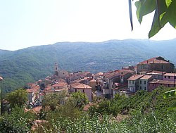
Apricale is a comune (municipality) in the Province of Imperia in the Italian region Liguria, located about 120 kilometres (75 mi) southwest of Genoa and about 30 kilometres (19 mi) west of Imperia.

Castellaro is a comune (municipality) in the Province of Imperia in the Italian region Liguria, located about 100 kilometres (62 mi) southwest of Genoa and about 14 kilometres (9 mi) west of Imperia. As of 31 December 2004, it had a population of 1,083 and an area of 8.7 square kilometres (3.4 sq mi).

Chiusavecchia is a comune (municipality) in the Province of Imperia in the Italian region Liguria, located about 90 kilometres (56 mi) southwest of Genoa and about 10 kilometres (6 mi) northwest of Imperia. As of 31 December 2004, it had a population of 488 and an area of 3.3 square kilometres (1.3 sq mi).

Diano Arentino is a comune (municipality) in the Province of Imperia in the Italian region Liguria, located about 90 kilometres (56 mi) southwest of Genoa and about 7 kilometres (4 mi) north of Imperia. As of 31 December 2004, it had a population of 648 and an area of 8.3 square kilometres (3.2 sq mi).
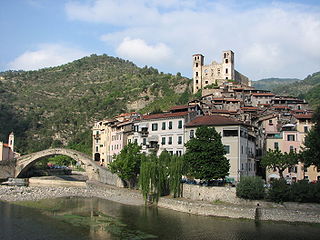
Dolceacqua is a comune (municipality) in the Province of Imperia in the Italian region Liguria, located about 120 kilometres (75 mi) southwest of Genoa and about 35 kilometres (22 mi) west of Imperia, on the border with France. As of 31 December 2014, it had a population of 2,078 and an area of 20.2 square kilometres (7.8 sq mi).

Isolabona is a comune (municipality) in the Province of Imperia in the Italian region Liguria, located about 120 kilometres (75 mi) southwest of Genoa and about 30 kilometres (19 mi) west of Imperia. As of 2011, it had a population of 716, spread between 333 families throughout an area of 12.4 square kilometres (4.8 sq mi).

Lucinasco is a comune (municipality) in the Province of Imperia in the Italian region Liguria, located about 90 kilometres (56 mi) southwest of Genoa and about 11 kilometres (7 mi) northwest of Imperia. As of 31 December 2004, it had a population of 268 and an area of 8.2 square kilometres (3.2 sq mi).

Ospedaletti is a comune (municipality) in the Province of Imperia in the Italian region of Liguria, located about 120 kilometres (75 mi) southwest of Genoa and about 25 kilometres (16 mi) southwest of Imperia.

Pontedassio is a comune (municipality) in the Province of Imperia in the Italian region Liguria. Which is located about 90 kilometres (56 mi) southwest of Genoa and about 6 kilometres (4 mi) north of Imperia. As of December 31, 2004, it has a population of 2,159 and an area of 14.5 square kilometres (5.6 sq mi).
Pornassio is a comune (municipality) in the Province of Imperia in the Italian region Liguria, located about 90 kilometres (56 mi) southwest of Genoa and about 25 kilometres (16 mi) northwest of Imperia. As of 31 December 2004, it had a population of 642 and an area of 27.7 square kilometres (10.7 sq mi).

Prelà is a comune (municipality) in the Province of Imperia in the Italian region Liguria, located about 100 kilometres (62 mi) southwest of Genoa and about 9 kilometres (6 mi) northwest of Imperia. As of 31 December 2004, it had a population of 497 and an area of 15.4 square kilometres (5.9 sq mi).
Riva Ligure is a comune (municipality) in the Province of Imperia in the Italian region Liguria, located about 110 kilometres (68 mi) southwest of Genoa and about 13 kilometres (8 mi) southwest of Imperia. As of 31 December 2004, it had a population of 2,830 and an area of 2.1 square kilometres (0.81 sq mi).

San Lorenzo al Mare is a comune (municipality) in the Province of Imperia in the Italian region Liguria, located about 100 kilometres southwest of Genoa and about 10 km (6 mi) west of Imperia. As of 31 December 2004, it had a population of 1,409 and an area of 1.3 square kilometres (0.5 sq mi).

Terzorio is a comune (municipality) in the Province of Imperia in the Italian region Liguria, located about 100 kilometres (62 mi) southwest of Genoa and about 11 kilometres (7 mi) southwest of Imperia. The municipality has an area of 1.9 square kilometres (0.73 sq mi).

Vasia is a comune (municipality) in the Province of Imperia in the Italian region Liguria, located about 100 kilometres (62 mi) southwest of Genoa and about 9 kilometres (6 mi) northwest of Imperia.

Vessalico is a comune (municipality) in the Province of Imperia in the Italian region Liguria, located about 90 kilometres (56 mi) southwest of Genoa and about 20 kilometres (12 mi) northwest of Imperia.
Villa Faraldi is a comune (municipality) in the Province of Imperia in the Italian region Liguria, located about 80 kilometres (50 mi) southwest of Genoa and about 10 kilometres (6 mi) northeast of Imperia. As of 31 December 2004, it had a population of 466 and an area of 9.6 square kilometres (3.7 sq mi).