
None is a comune (municipality) in the Metropolitan City of Turin in the Italian region Piedmont, located about 20 kilometres (12 mi) southwest of Turin.

Montemagno is a comune (municipality) in the Province of Asti in the Italian region Piedmont, located about 50 kilometres (31 mi) east of Turin and about 13 kilometres (8 mi) northeast of Asti. As of 31 December 2010 it had a population of 1,228 and an area of 15.9 square kilometres (6.1 sq mi).

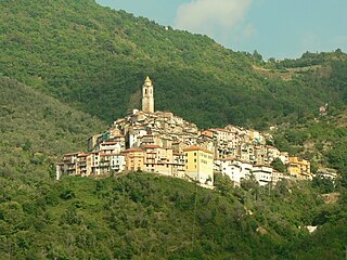
Apricale is a comune (municipality) in the Province of Imperia in the Italian region Liguria, located about 120 kilometres (75 mi) southwest of Genoa and about 30 kilometres (19 mi) west of Imperia.

For people with the surname, see Badalucco (surname).

Camporosso is a comune (municipality) in the Province of Imperia in the Italian region Liguria, located about 160 kilometres (99 mi) southwest of Genoa and about 45 kilometres (28 mi) west of Imperia.
Castelvittorio is a comune (municipality) in the Province of Imperia in the Italian region Liguria, located about 120 kilometres (75 mi) southwest of Genoa and about 30 kilometres (19 mi) west of Imperia.

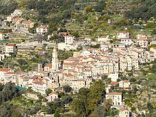
Ceriana is a comune (municipality) in the Province of Imperia in the Italian region Liguria, located about 110 kilometres (68 mi) southwest of Genoa and about 20 kilometres (12 mi) west of Imperia. As of 2018, it had a population of 1,214 and an area of 32.1 square kilometres (12.4 sq mi).

Diano Castello is a comune (municipality) in the Province of Imperia in the Italian region Liguria, located about 90 kilometres (56 mi) southwest of Genoa and about 5 kilometres (3 mi) northeast of Imperia. As of 31 December 2004, it had a population of 2,061 and an area of 6.0 square kilometres (2.3 sq mi).

Dolcedo is a comune (municipality) in the Province of Imperia in the Italian region Liguria, located about 100 kilometres (62 mi) southwest of Genoa and about 7 kilometres (4 mi) northwest of Imperia.

Molini di Triora is a comune (municipality) in the Province of Imperia in the Italian region Liguria, located about 100 kilometres (62 mi) southwest of Genoa and about 25 kilometres (16 mi) northwest of Imperia. As of 31 December 2004, it had a population of 741 and an area of 57.9 square kilometres (22.4 sq mi).

Perinaldo is a comune (municipality) in the Province of Imperia in the Italian region Liguria, located about 120 kilometres (75 mi) southwest of Genoa and about 30 kilometres (19 mi) west of Imperia.

San Biagio della Cima is a comune (municipality) in the Province of Imperia in the Italian region Liguria, located about 120 kilometres (75 mi) southwest of Genoa and about 30 kilometres (19 mi) west of Imperia.

Taggia is a comune (municipality) in the Province of Imperia in the Italian region Liguria, located about 110 kilometres southwest of Genoa and about 15 km (9 mi) west of Imperia. It has around 13,000 inhabitants.
Vallebona is a comune (municipality) in the Province of Imperia in the Italian region Liguria, located about 120 kilometres (75 mi) southwest of Genoa and about 30 kilometres (19 mi) west of Imperia. Vallebona borders the following municipalities: Bordighera, Ospedaletti, Perinaldo, San Biagio della Cima, Seborga, Soldano, and Vallecrosia.

Vallecrosia is a comune (municipality) in the Province of Imperia in the Italian region Liguria, located about 120 kilometres (75 mi) southwest of Genoa and about 30 kilometres (19 mi) west of Imperia. It is next to the busy city of Ventimiglia.
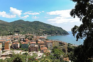
Levanto is a comune (municipality) in the province of La Spezia in the Italian region of Liguria, located almost 90 kilometres (56 mi) southeast of Genoa and about 20 kilometres (12 mi) northwest of La Spezia. The town is on the coast at the mouth of a river valley, between hills thickly wooded with olive and pine trees. The ridges on either side of the valley thrust out into the sea as the headlands of Mesco and Levanto. The municipality forms part of the coastal district known as the Comunità Montana della Riviera Spezzina, and part of its territory is included in the Cinque Terre National Park.
San Nicolò di Comelico is a comune (municipality) in the province of Belluno in the Italian region of Veneto, located about 130 kilometres (81 mi) north of Venice.

Gangi is a comune (municipality) in the Metropolitan City of Palermo in the Italian region Sicily, located about 80 kilometres (50 mi) southeast of Palermo.

Imperia Porto Maurizio railway station was one of two stations serving the city and comune of Imperia, in Liguria, northwestern Italy. Opened in 1872, it formed part of the Genoa–Ventimiglia railway, and was situated just over two thirds along the way from Genoa towards Ventimiglia. It was replaced on December 11, 2016, along with Imperia's other former railway station, Imperia Oneglia, 2.2 kilometres (1.4 mi) to the east, by a new inland station, simply named Imperia, situated on a new double-track line replacing the old coastal route.
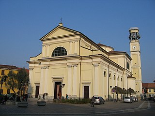
The Church of Saint Bartholomew is the cathedral and the oldest parish in Brugherio, Italy. It houses relics of the three Magi. It is characterised by its relatively high bell tower measuring 36.8 metres (121 ft).


