Briga Alta is a comune (municipality) in the Province of Cuneo in the Italian region Piedmont.
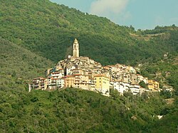
Apricale is a comune (municipality) in the Province of Imperia in the Italian region Liguria, located about 120 kilometres (75 mi) southwest of Genoa and about 30 kilometres (19 mi) west of Imperia.
For people with the surname, see Badalucco (surname).

Castellaro is a comune (municipality) in the Province of Imperia in the Italian region Liguria, located about 100 kilometres (62 mi) southwest of Genoa and about 14 kilometres (9 mi) west of Imperia. As of 31 December 2004, it had a population of 1,083 and an area of 8.7 square kilometres (3.4 sq mi).

Cipressa is a comune (municipality) in the Province of Imperia in the Italian region Liguria, located about 100 kilometres (62 mi) southwest of Genoa and about 9 kilometres (6 mi) southwest of Imperia. As of 31 December 2004, it had a population of 1,183 and an area of 9.5 square kilometres (3.7 sq mi).

Civezza is a comune (municipality) in the Province of Imperia in the Italian region Liguria, located about 127 kilometres (79 mi) southwest of Genoa and about 7 kilometres (4 mi) west of Imperia. As of 31 December 2004, it had a population of 557 and an area of 3.8 square kilometres (1.5 sq mi).

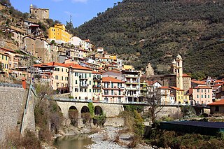
Diano Castello is a comune (municipality) in the Province of Imperia in the Italian region Liguria, located about 90 kilometres (56 mi) southwest of Genoa and about 5 kilometres (3 mi) northeast of Imperia. As of 31 December 2004, it had a population of 2,061 and an area of 6.0 square kilometres (2.3 sq mi).

Isolabona is a comune (municipality) in the Province of Imperia in the Italian region Liguria, located about 120 kilometres (75 mi) southwest of Genoa and about 30 kilometres (19 mi) west of Imperia. As of 2011, it had a population of 716, spread between 333 families throughout an area of 12.4 square kilometres (4.8 sq mi).

Mendatica is a comune (municipality) in the Province of Imperia in the Italian region Liguria, located about 100 kilometres (62 mi) southwest of Genoa and about 30 kilometres (19 mi) northwest of Imperia.

Molini di Triora is a comune (municipality) in the Province of Imperia in the Italian region Liguria, located about 100 kilometres (62 mi) southwest of Genoa and about 25 kilometres (16 mi) northwest of Imperia. As of 31 December 2004, it had a population of 741 and an area of 57.9 square kilometres (22.4 sq mi).

Montegrosso Pian Latte is a comune (municipality) in the Province of Imperia in the Italian region Liguria, located about 100 kilometres (62 mi) southwest of Genoa and about 25 kilometres (16 mi) northwest of Imperia.

Olivetta San Michele is a comune (municipality) in the Province of Imperia in the Italian region Liguria, located about 130 kilometres (81 mi) southwest of Genoa and about 40 kilometres (25 mi) west of Imperia, on the border with France. As of 31 December 2004, it had a population of 245 and an area of 13.8 square kilometres (5.3 sq mi).

Ospedaletti is a comune (municipality) in the Province of Imperia in the Italian region of Liguria, located about 120 kilometres (75 mi) southwest of Genoa and about 25 kilometres (16 mi) southwest of Imperia.

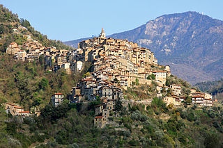
Perinaldo is a comune (municipality) in the Province of Imperia in the Italian region of Liguria, located about 120 kilometres (75 mi) southwest of Genoa and about 30 kilometres (19 mi) west of Imperia.

Pigna is a comune (municipality) in the Province of Imperia in the Italian region of Liguria, located about 110 kilometres (68 mi) southwest of Genoa and about 30 kilometres (19 mi) west of Imperia, on the border with France. In 2024, it has an evaluated population of 741 and an area of 53.7 square kilometres (20.7 sq mi).
Pornassio is a comune (municipality) in the Province of Imperia in the Italian region Liguria, located about 90 kilometres (56 mi) southwest of Genoa and about 25 kilometres (16 mi) northwest of Imperia. As of 31 December 2004, it had a population of 642 and an area of 27.7 square kilometres (10.7 sq mi).

Rezzo is a comune (municipality) in the Province of Imperia in the Italian region Liguria, located about 100 kilometres (62 mi) southwest of Genoa and about 20 kilometres (12 mi) northwest of Imperia.
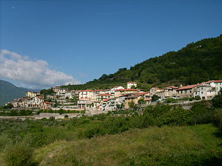
San Lorenzo al Mare is a comune (municipality) in the Province of Imperia in the Italian region Liguria, located about 100 kilometres southwest of Genoa and about 10 km (6 mi) west of Imperia. As of 31 December 2004, it had a population of 1,409 and an area of 1.3 square kilometres (0.5 sq mi).

Terzorio is a comune (municipality) in the Province of Imperia in the Italian region Liguria, located about 100 kilometres (62 mi) southwest of Genoa and about 11 kilometres (7 mi) southwest of Imperia. The municipality has an area of 1.9 square kilometres (0.73 sq mi).
Triora is a comune (municipality) in the province of Imperia in the Italian region Liguria, located about 100 kilometres (62 mi) southwest of Genoa and about 25 kilometres (16 mi) northwest of Imperia, on the border with France. As of 31 December 2004, it had a population of 416 and an area of 68.0 square kilometres (26.3 sq mi).