Airole | ||
---|---|---|
Comune | ||
Comune di Airole | ||
Airole | ||
| ||
Coordinates: 43°52′N7°33′E / 43.867°N 7.550°E Coordinates: 43°52′N7°33′E / 43.867°N 7.550°E | ||
Country | Italy | |
Region | Liguria | |
Province | Province of Imperia (IM) | |
Frazioni | Collabassa, case Noceire, case Giauma | |
Area | ||
• Total | 14.8 km2 (5.7 sq mi) | |
Elevation | 149 m (489 ft) | |
Population (Dec. 2004) | ||
• Total | 461 | |
• Density | 31/km2 (81/sq mi) | |
Demonym(s) | Airolesi | |
Time zone | CET (UTC+1) | |
• Summer (DST) | CEST (UTC+2) | |
Postal code | 18030 | |
Dialing code | 0184 | |
Website | Official website |
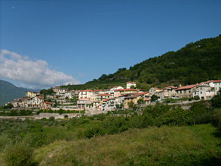
Airole (Ligurian :Airöe, locally Airöre) is a comune (municipality) in the Province of Imperia in the Italian region of Liguria, located about 130 kilometres (81 mi) southwest of Genoa and about 40 kilometres (25 mi) west of Imperia, on the border with France. As of 31 December 2004, it had a population of 461 and an area of 14.8 square kilometres (5.7 sq mi). [1]
Ligurian is a Gallo-Italic language spoken in Liguria in Northern Italy, parts of the Mediterranean coastal zone of France, Monaco and in the villages of Carloforte and Calasetta in Sardinia. It is part of the Gallo-Italic and Western Romance dialect continuum. The Genoese (Zeneize), spoken in Genoa, the capital of Liguria, is the language's prestige dialect on which the standard is based.
The comune is a basic administrative division in Italy, roughly equivalent to a township or municipality.
The Province of Imperia is a mountainous and hilly province, in the Liguria region of Italy, situated between France to the north and the Ligurian Sea, an arm of the Mediterranean Sea to the south. Its capital is the city of Imperia.
The municipality of Airole contains the frazioni (subdivisions, mainly villages and hamlets) Collabassa, case Noceire, and case Giauma.
"Frazione" is the Italian name given in administrative law to a type of territorial subdivision of a comune; for other administrative divisions, see municipio, circoscrizione, quartiere. It is cognate to the English word fraction, but in practice is roughly equivalent to "parishes" or "wards" in other countries.
Airole borders the following municipalities: Breil-sur-Roya (France), Dolceacqua, Olivetta San Michele, and Ventimiglia.
Breil-sur-Roya is a commune in the Alpes-Maritimes department in southeastern France.
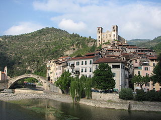
Dolceacqua is a comune (municipality) in the Province of Imperia in the Italian region Liguria, located about 120 kilometres (75 mi) southwest of Genoa and about 35 kilometres (22 mi) west of Imperia, on the border with France. As of 31 December 2014, it had a population of 2,078 and an area of 20.2 square kilometres (7.8 sq mi).
Olivetta San Michele is a comune (municipality) in the Province of Imperia in the Italian region Liguria, located about 130 kilometres (81 mi) southwest of Genoa and about 40 kilometres (25 mi) west of Imperia, on the border with France. As of 31 December 2004, it had a population of 245 and an area of 13.8 square kilometres (5.3 sq mi).
Apricale is a comune (municipality) in the Province of Imperia in the Italian region Liguria, located about 120 kilometres (75 mi) southwest of Genoa and about 30 kilometres (19 mi) west of Imperia.
Armo is a comune (municipality) in the Province of Imperia in the Italian region Liguria, located about 90 kilometres (56 mi) southwest of Genoa and about 25 kilometres (16 mi) northwest of Imperia.
Carpasio is a former comune (municipality) in the Province of Imperia in the Italian region Liguria, located about 100 kilometres (62 mi) southwest of Genoa and about 15 kilometres (9 mi) northwest of Imperia. As of 31 December 2004, it had a population of 180 and an area of 16.1 square kilometres (6.2 sq mi). At the beginning of 2018 Caprasio was unified with Montalto Ligure in the new comune of Montalto Carpasio.
Castellaro is a comune (municipality) in the Province of Imperia in the Italian region Liguria, located about 100 kilometres (62 mi) southwest of Genoa and about 14 kilometres (9 mi) west of Imperia. As of 31 December 2004, it had a population of 1,083 and an area of 8.7 square kilometres (3.4 sq mi).
Cesio is a comune (municipality) in the Province of Imperia in the Italian region Liguria, located about 90 kilometres (56 mi) southwest of Genoa and about 14 kilometres (9 mi) northwest of Imperia.
Chiusavecchia is a comune (municipality) in the Province of Imperia in the Italian region Liguria, located about 90 kilometres (56 mi) southwest of Genoa and about 10 kilometres (6 mi) northwest of Imperia. As of 31 December 2004, it had a population of 488 and an area of 3.3 square kilometres (1.3 sq mi).
Cosio di Arroscia is a comune (municipality) in the province of Imperia in the Italian region Liguria, located about 100 kilometres (62 mi) southwest of Genoa and about 25 kilometres (16 mi) northwest of Imperia.
Montegrosso Pian Latte is a comune (municipality) in the Province of Imperia in the Italian region Liguria, located about 100 kilometres (62 mi) southwest of Genoa and about 25 kilometres (16 mi) northwest of Imperia.
Ospedaletti is a comune (municipality) in the Province of Imperia in the Italian region of Liguria, located about 120 kilometres (75 mi) southwest of Genoa and about 25 kilometres (16 mi) southwest of Imperia.
Pieve di Teco is a comune (municipality) in the Province of Imperia in the Italian region Liguria, located about 90 kilometres (56 mi) southwest of Genoa and about 20 kilometres (12 mi) northwest of Imperia.
Pornassio is a comune (municipality) in the Province of Imperia in the Italian region Liguria, located about 90 kilometres (56 mi) southwest of Genoa and about 25 kilometres (16 mi) northwest of Imperia. As of 31 December 2004, it had a population of 642 and an area of 27.7 square kilometres (10.7 sq mi).
Prelà is a comune (municipality) in the Province of Imperia in the Italian region Liguria, located about 100 kilometres (62 mi) southwest of Genoa and about 9 kilometres (6 mi) northwest of Imperia. As of 31 December 2004, it had a population of 497 and an area of 15.4 square kilometres (5.9 sq mi).
Riva Ligure is a comune (municipality) in the Province of Imperia in the Italian region Liguria, located about 110 kilometres (68 mi) southwest of Genoa and about 13 kilometres (8 mi) southwest of Imperia. As of 31 December 2004, it had a population of 2,830 and an area of 2.1 square kilometres (0.81 sq mi).
Rocchetta Nervina is a comune (municipality) in the province of Imperia in the Italian region of Liguria. It is located about 120 kilometres (75 mi) southwest of Genoa and about 35 kilometres (22 mi) west of Imperia, on the border with France.
San Lorenzo al Mare is a comune (municipality) in the Province of Imperia in the Italian region Liguria, located about 100 kilometres southwest of Genoa and about 10 km (6 mi) west of Imperia. As of 31 December 2004, it had a population of 1,409 and an area of 1.3 square kilometres (0.5 sq mi).
Terzorio is a comune (municipality) in the Province of Imperia in the Italian region Liguria, located about 100 kilometres (62 mi) southwest of Genoa and about 11 kilometres (7 mi) southwest of Imperia. The municipality has an area of 1.9 square kilometres (0.73 sq mi).
Vasia is a comune (municipality) in the Province of Imperia in the Italian region Liguria, located about 100 kilometres (62 mi) southwest of Genoa and about 9 kilometres (6 mi) northwest of Imperia.
Vessalico is a comune (municipality) in the Province of Imperia in the Italian region Liguria, located about 90 kilometres (56 mi) southwest of Genoa and about 20 kilometres (12 mi) northwest of Imperia.
This Liguria location article is a stub. You can help Wikipedia by expanding it. |