Vasia

Last updated
Vasia
Comune
Comune di Vasia
Italy provincial location map 2015.svg
Red pog.svg
Vasia
Location of Vasia in Italy
Coordinates: 43°56′N7°57′E / 43.933°N 7.950°E / 43.933; 7.950 Coordinates: 43°56′N7°57′E / 43.933°N 7.950°E / 43.933; 7.950
Country Italy
Region Liguria
Province Province of Imperia (IM)
Area
  Total 10.8 km2 (4.2 sq mi)
Elevation 385 m (1,263 ft)
Population (Dec. 2004)
  Total 423
  Density 39/km2 (100/sq mi)
Demonym(s) Vasiesi
Time zone CET (UTC+1)
  Summer (DST) CEST (UTC+2)
Postal code18020
Dialing code 0183
Website Official website

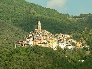
Vasia is a comune (municipality) in the Province of Imperia in the Italian region Liguria, located about 100 kilometres (62 mi) southwest of Genoa and about 9 kilometres (6 mi) northwest of Imperia. As of 31 December 2004, it had a population of 423 and an area of 10.8 square kilometres (4.2 sq mi). [1]

<i>Comune</i> third-level administrative divisions of the Italian Republic

The comune is a basic administrative division in Italy, roughly equivalent to a township or municipality.

Province of Imperia Province of Italy

The Province of Imperia is a mountainous and hilly province, in the Liguria region of Italy, situated between France to the north and the Ligurian Sea, an arm of the Mediterranean Sea to the south. Its capital is the city of Imperia.

Italy republic in Southern Europe

Italy, officially the Italian Republic, is a country in Southern Europe. Located in the middle of the Mediterranean Sea, Italy shares open land borders with France, Switzerland, Austria, Slovenia and the enclaved microstates San Marino and Vatican City. Italy covers an area of 301,340 km2 (116,350 sq mi) and has a largely temperate seasonal and Mediterranean climate. With around 61 million inhabitants, it is the fourth-most populous EU member state and the most populous country in Southern Europe.

Contents

Vasia borders the following municipalities: Borgomaro, Dolcedo, Imperia, Lucinasco, Pontedassio, and Prelà.

Borgomaro Comune in Liguria, Italy

Borgomaro is a comune (municipality) in the Province of Imperia in the Italian region Liguria, located about 90 kilometres (56 mi) southwest of Genoa and about 13 kilometres (8 mi) northwest of Imperia.

Dolcedo Comune in Liguria, Italy

Dolcedo is a comune (municipality) in the Province of Imperia in the Italian region Liguria, located about 100 kilometres (62 mi) southwest of Genoa and about 7 kilometres (4 mi) northwest of Imperia.

Lucinasco Comune in Liguria, Italy

Lucinasco is a comune (municipality) in the Province of Imperia in the Italian region Liguria, located about 90 kilometres (56 mi) southwest of Genoa and about 11 kilometres (7 mi) northwest of Imperia. As of 31 December 2004, it had a population of 268 and an area of 8.2 square kilometres (3.2 sq mi).

Demographic evolution

Vasia

Related Research Articles

Apricale Comune in Liguria, Italy

Apricale is a comune (municipality) in the Province of Imperia in the Italian region Liguria, located about 120 kilometres (75 mi) southwest of Genoa and about 30 kilometres (19 mi) west of Imperia.

Aquila dArroscia Comune in Liguria, Italy

Aquila d'Arroscia is a comune (municipality) in the Province of Imperia in the Italian region Liguria, located about 80 kilometres (50 mi) southwest of Genoa and about 20 kilometres (12 mi) north of Imperia.

Armo Comune in Liguria, Italy

Armo is a comune (municipality) in the Province of Imperia in the Italian region Liguria, located about 90 kilometres (56 mi) southwest of Genoa and about 25 kilometres (16 mi) northwest of Imperia.

Aurigo Comune in Liguria, Italy

Aurigo is a comune (municipality) in the Province of Imperia in the Italian region Liguria, located about 90 kilometres (56 mi) southwest of Genoa and about 15 kilometres (9 mi) northwest of Imperia.

Badalucco Comune in Liguria, Italy

For people with the surname, see Badalucco (surname).

Borghetto dArroscia Comune in Liguria, Italy

Borghetto d'Arroscia is a comune (municipality) in the Province of Imperia in the Italian region Liguria, located about 90 kilometres (56 mi) southwest of Genoa and about 20 kilometres (12 mi) north of Imperia.

Castellaro Comune in Liguria, Italy

Castellaro is a comune (municipality) in the Province of Imperia in the Italian region Liguria, located about 100 kilometres (62 mi) southwest of Genoa and about 14 kilometres (9 mi) west of Imperia. As of 31 December 2004, it had a population of 1,083 and an area of 8.7 square kilometres (3.4 sq mi).

Castel Vittorio Comune in Liguria, Italy

Castelvittorio is a comune (municipality) in the Province of Imperia in the Italian region Liguria, located about 120 kilometres (75 mi) southwest of Genoa and about 30 kilometres (19 mi) west of Imperia.

Cesio Comune in Liguria, Italy

Cesio is a comune (municipality) in the Province of Imperia in the Italian region Liguria, located about 90 kilometres (56 mi) southwest of Genoa and about 14 kilometres (9 mi) northwest of Imperia.

Chiusanico Comune in Liguria, Italy

Chiusanico is a comune (municipality) in the Province of Imperia in the Italian region of Liguria, located about 90 kilometres (56 mi) southwest of Genoa and about 10 kilometres (6 mi) northwest of Imperia.

Chiusavecchia Comune in Liguria, Italy

Chiusavecchia is a comune (municipality) in the Province of Imperia in the Italian region Liguria, located about 90 kilometres (56 mi) southwest of Genoa and about 10 kilometres (6 mi) northwest of Imperia. As of 31 December 2004, it had a population of 488 and an area of 3.3 square kilometres (1.3 sq mi).

Cipressa Comune in Liguria, Italy

Cipressa is a comune (municipality) in the Province of Imperia in the Italian region Liguria, located about 100 kilometres (62 mi) southwest of Genoa and about 9 kilometres (6 mi) southwest of Imperia. As of 31 December 2004, it had a population of 1,183 and an area of 9.5 square kilometres (3.7 sq mi).

Pontedassio Comune in Liguria, Italy

Pontedassio is a comune (municipality) in the Province of Imperia in the Italian region Liguria. Which is located about 90 kilometres (56 mi) southwest of Genoa and about 6 kilometres (4 mi) north of Imperia. As of December 31, 2004, it has a population of 2,159 and an area of 14.5 square kilometres (5.6 sq mi).

Prelà Comune in Liguria, Italy

Prelà is a comune (municipality) in the Province of Imperia in the Italian region Liguria, located about 100 kilometres (62 mi) southwest of Genoa and about 9 kilometres (6 mi) northwest of Imperia. As of 31 December 2004, it had a population of 497 and an area of 15.4 square kilometres (5.9 sq mi).

Riva Ligure Comune in Liguria, Italy

Riva Ligure is a comune (municipality) in the Province of Imperia in the Italian region Liguria, located about 110 kilometres (68 mi) southwest of Genoa and about 13 kilometres (8 mi) southwest of Imperia. As of 31 December 2004, it had a population of 2,830 and an area of 2.1 square kilometres (0.81 sq mi).

San Bartolomeo al Mare Comune in Liguria, Italy

San Bartolomeo al Mare is a comune (municipality) in the Province of Imperia in the Italian region Liguria, located about 90 kilometres (56 mi) southwest of Genoa and about 7 kilometres (4 mi) northeast of Imperia.

Terzorio Comune in Liguria, Italy

Terzorio is a comune (municipality) in the Province of Imperia in the Italian region Liguria, located about 100 kilometres (62 mi) southwest of Genoa and about 11 kilometres (7 mi) southwest of Imperia. The municipality has an area of 1.9 square kilometres (0.73 sq mi).

References

  1. All demographics and other statistics: Italian statistical institute Istat.