Aßlar

Last updated • 3 min readFrom Wikipedia, The Free Encyclopedia
Aßlar
Blick auf Asslar.jpg
General view
Wappen Asslar.png
Location of Aßlar within Lahn-Dill district
Lahn-Dill-Kreis Asslar.pngBreitscheidHerbornSinn
Germany adm location map.svg
Red pog.svg
Aßlar
Hesse location map.svg
Red pog.svg
Aßlar
Coordinates: 50°35′N08°28′E / 50.583°N 8.467°E / 50.583; 8.467
Country Germany
State Hesse
Admin. region Gießen
District Lahn-Dill
Subdivisions6 Stadtteile/Stadtbezirke
Government
   Mayor (201925) Christian Schwarz [1] (FW)
Area
  Total43.57 km2 (16.82 sq mi)
Elevation
175 m (574 ft)
Population
 (2022-12-31) [2]
  Total13,924
  Density320/km2 (830/sq mi)
Time zone UTC+01:00 (CET)
  Summer (DST) UTC+02:00 (CEST)
Postal codes
35614
Dialling codes 06441, 06443,06440, 06446
Vehicle registration LDK
Website www.asslar.de

Aßlar (or Asslar, [ˈaslaʁ] ) is a town near Wetzlar in the Lahn-Dill-Kreis in Hesse, Germany.

Contents

Geography

Location

Aßlar lies in the foothills of the Westerwald range and on the river Dill, which empties into the Lahn in neighbouring Wetzlar, about 5 km to the southeast. It is also not far from the "three-state-border", a geographical point common to the German states of Hesse, North Rhine-Westphalia and Rhineland-Palatinate, lying to the west.

The Aßlar community of Werdorf also lies on the River Dill, as do Klein-Altenstädten and Berghausen. Bechlingen, Oberlemp and Bermoll lie north of the main town, away from the river.

Neighbouring communities

Aßlar borders in the north on the communities of Mittenaar and Hohenahr, in the east on the town of Wetzlar, in the south on the town of Solms, and in the west on the community of Ehringshausen (all in the Lahn-Dill-Kreis).

Constituent communities

Aßlar is divided into the following communities or Stadtteile:

The communities of Werdorf and Berghausen are so near each other that they merge one into the other, but are officially two Stadtteile, which may be considered "wards" or possibly "boroughs".

History

Aßlar was first mentioned in 783 A.D. in a charter of a ecclesiastical grant copied into the Lorsch codex (or Codex Laureshamensis in Latin).

Like many other places, Aßlar grew from a few great estates to about 5,000 by the time of the First World War, always forming a community with Klein-Altenstädten on the other side of the River Dill. Following the Second World War, a great number of refugees settled in the area from various lost German territories. The municipal reforms of 1977 led to its amalgamation with Bechlingen, Berghausen, Bermoll, Oberlemp and Werdorf to produce today's town of Aßlar.

Aßlar was granted town status in 1978.

Werdorf

In the Bronze Age, people settled on the Schönbach, which flowed through the area, as this stream was more easily forded than the broader River Dill. Werdorf was first mentioned in the historical record in 772 A.D.

"Werdorf" comes from an Old Germanic root "Wero", meaning "man". This root is common to many Germanic languages, and can also be seen in the English words "wergild" and "werewolf". Dorf is still the German word for a village, and has cognates in other Germanic languages, including "thorp" in English.

Tradition tells of a legend recounting how Werdorf got its name, namely:

There were once two countesses who were riding together along the Dill, when they found a place they rather liked, and they had a stately home built there. Since now the workmen were living here, one countess said "May it become a town!". The other answered "No, may it become a village!" (in German: "Nein, es werde ein Dorf!")
And so, from "Werd-Dorf" came the village's name.

Politics

Town council

The municipal elections on 26 March 2006 yielded the following results:

FWG14
SPD 11
CDU 9
Greens 2
FDP 1

Note: FWG is a citizens' coalition.

Coat of arms

Approval to bear a coat of arms and a flag was granted to the town in 1959 and 1960 by the Hessian government. The colors and heraldic composition of the arms, appear to originate with the Counts of Solms and the Lords of Bicken who are represented by the lion and the lozenge. They were the chief medieval noble families of the surrounding area. The hazelnut refers to that interpretation of the town's name, which derives it from the word "Haselare", where "Hasel" in "hazel" in German. This word was used in early medieval times for a sacred place separated from the profane by an enclosure of hazel rods. This sacred place was later appropriated by the local Christian bishop and a church was constructed on the site, which is still there today, and where Christian worship is conducted weekly.

Twin towns

Aßlar is twinned with Flag of France.svg Saint-Ambroix, France since 1966; and Flag of Germany.svg Jüterbog, Brandenburg since 1991.

Culture

Museums

There is the Museum of Local History at the Werdorfer Schloss in Werdorf, and the Grube Fortuna, a tourist mine outside Berghausen.

Buildings

The Werdorfer Schloss is a stately home built in Werdorf between 1680 and 1700 by the Counts of Solms-Greifenstein.

Music

The contemporary Christian band, Outbreakband, is based in Aßlar.

Clubs

There are some eighty clubs based in Aßlar.

Economy and infrastructure

Aßlar is today a small industrial town with well-developed infrastructure, where the firms Pfeiffer Vacuum and Manfred Huck are established. The latter has its head office in Berghausen for the manufacture of quality nets and rope for sport, industry and education.

Also in Berghausen is a civic wireless local network using the 802.11g standard, for WiFi access to the Internet.

There are many public barbecues and hiking trails to be enjoyed in the surrounding area, as well as a public swimming pool.

Related Research Articles

<span class="mw-page-title-main">Wetzlar</span> City in Hesse, Germany

Wetzlar is a city in the state of Hesse, Germany. It is the twelfth largest city in Hesse with currently 55,371 inhabitants at the beginning of 2019. As an important cultural, industrial and commercial center, the university town is one of the ten regional centers in the state of Hesse. A former free imperial city, it gained much of its fame as the seat of the Imperial Supreme Court (Reichskammergericht) of the Holy Roman Empire. Located 51 kilometers north of Frankfurt, at 8° 30′ E, 50° 34′ N, Wetzlar straddles the river Lahn and is on the German Timber-Frame Road, which passes mile upon mile of half-timbered houses. Historically, the city has acted as the hub of the Lahn-Dill-Kreis on the north edge of the Taunus. Tourists know the city for its ancient town and its medieval Catholic/Protestant shared cathedral of St. Mary. Notable architectural features include the Eisenmarkt and the steep gradients and tightly packed street layout of a medieval town. The building of the sandstone cathedral commenced in the 12th century in Romanesque style. In the later Middle Ages the construction continued under a master plan in Gothic style. The church was never finished—one steeple still remains uncompleted. The cathedral suffered heavy damage in the Second World War from aerial bombing, but restoration took place in the 1950s. On the outskirts of town along the river stand the ruins of several stone towers.

Lahn-Dill is a Kreis (district) in the west of Hesse, Germany. Neighboring districts are Siegen-Wittgenstein, Marburg-Biedenkopf, Gießen, Wetteraukreis, Hochtaunuskreis, Limburg-Weilburg, Westerwaldkreis.

<span class="mw-page-title-main">Dillenburg</span> Town in Hesse, Germany

Dillenburg, officially Oranienstadt Dillenburg, is a town in Hesse's Gießen region in Germany. The town was formerly the seat of the old Dillkreis district, which is now part of the Lahn-Dill-Kreis.

<span class="mw-page-title-main">Leun</span> Town in Hesse, Germany

Leun is a small town in the Lahn-Dill-Kreis in Hesse, Germany.

<span class="mw-page-title-main">Steffenberg</span> Municipality in Hesse, Germany

Steffenberg is a municipality in Marburg-Biedenkopf district in Hesse, Germany.

<span class="mw-page-title-main">Birkenau (Odenwald)</span> Municipality in Hesse, Germany

Birkenau in the Odenwald is a municipality in the Bergstraße district in southern Hesse, Germany. Its nickname is Das Dorf der Sonnenuhren – “The Sundial Village”.

<span class="mw-page-title-main">Solms</span> Town in Hesse, Germany

Solms is a town west of Wetzlar in the Lahn-Dill-Kreis, Hessen, Germany with around 13,500 inhabitants. In the constituent community of Burgsolms once stood the ancestral castle of the Counts and Princes of Solms.

<span class="mw-page-title-main">Oestrich-Winkel</span> Town in Hesse, Germany

Oestrich-Winkel is a town with roughly 12,000 inhabitants in the Rheingau-Taunus-Kreis in the Regierungsbezirk of Darmstadt in Hesse, Germany.

<span class="mw-page-title-main">Bischoffen</span> Municipality in Hesse, Germany

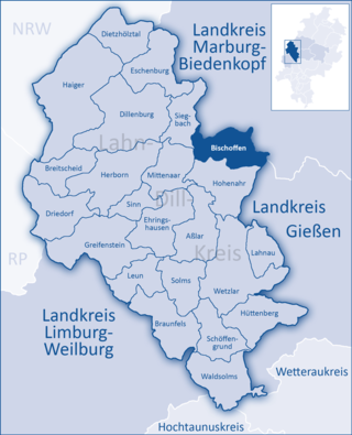
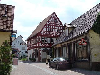
Bischoffen is a municipality in the Lahn-Dill-Kreis in Hesse, Germany.

<span class="mw-page-title-main">Braunfels</span> Town in Hesse, Germany

Braunfels is a town in the Lahn-Dill-Kreis in Hesse, Germany. It is located on the German Timber-Frame Road.

<span class="mw-page-title-main">Dill (river)</span> River in Germany

The Dill is a 55 km (34 mi) long river, flowing through central Hesse in Germany. It is a tributary to the Lahn, joining it on the right bank at the town of Wetzlar.

<span class="mw-page-title-main">Hüttenberg</span> Municipality in Hesse, Germany

Hüttenberg is a municipality in the Lahn-Dill-Kreis in Hesse, Germany.

<span class="mw-page-title-main">Ehringshausen</span> Municipality in Hesse, Germany

Ehringshausen is a municipality in the Lahn-Dill-Kreis in Hesse, Germany.

<span class="mw-page-title-main">Hohenahr</span> Municipality in Hesse, Germany

Hohenahr is a municipality in the Lahn-Dill-Kreis in Hesse, Germany.

<span class="mw-page-title-main">Lahnau</span> Municipality in Hesse, Germany

Lahnau is a municipality in the Lahn-Dill-Kreis in Hesse, Germany, and lies about midway – about 6 km each way – between the towns of Wetzlar and Gießen.

<span class="mw-page-title-main">Schöffengrund</span> Municipality in Hesse, Germany

Schöffengrund is a municipality in the Lahn-Dill-Kreis in Hesse, Germany.

<span class="mw-page-title-main">Sinn, Hesse</span> Municipality in Hesse, Germany

Sinn is a municipality in Middle Hesse, Germany, in the Lahn-Dill-Kreis.

<span class="mw-page-title-main">Waldsolms</span> Municipality in Hesse, Germany

Waldsolms is a municipality located in the Lahn-Dill-Kreis in Hesse, Germany.

<span class="mw-page-title-main">Löhnberg</span> Municipality in Hesse, Germany

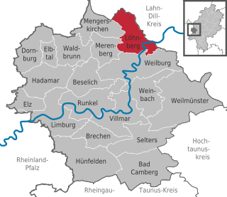
Löhnberg is a municipality north of Weilburg in Limburg-Weilburg district in Hesse, Germany.

<span class="mw-page-title-main">Albshausen station</span> Railway station in Solms, Germany

Albshausen is a station in the north of the district of Albshausen in the town of Solms in the German state of Hesse. The station is located on the Lahn Valley Railway (Lahntalbahn) and only a few metres from the Lahn river. Previously, the Solmsbach Valley Railway (Solmsbachtalbahn) branched off to Gravenwiesbach.

References

  1. "Ergebnisse der letzten Direktwahl aller hessischen Landkreise und Gemeinden" (XLS) (in German). Hessisches Statistisches Landesamt. 5 September 2022.
  2. "Bevölkerung in Hessen am 31.12.2022 nach Gemeinden" (XLS) (in German). Hessisches Statistisches Landesamt. June 2023.