Discovery
Kerguelen could see the side during his first voyage in February 1772, but could not land, and anchored at the South, in Baie du Lion-Marin, where he claimed the archipelago for France. In his second voyage, in December 1773, he entered the harbour and named in Baie de l'Oiseau, after the frigate Oiseau, under Rosnovet, one of the ships of the expedition. On 6 January 1774, he sent Rochegude ashore to leave a bottle with a message claiming the site for France. On 2 January 1893, Commander Lieutard, of aviso Eure, renewed the claim.
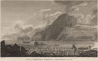
Arrival of
James Cook in 1776 (engraving by
John Webber, 1784).
Baie de l'oiseau photographed by the aviso
Eure on 2 January 1893, when France claimed the territory. The
Kerguelen Arch is visible in the background.
Fauna and flora
The flora is limited to moss and lichens in a tundra ecosystem, as well as a cane grass at the mouth of the spillway of Lake Rochegude. There are no trees or bushes, which inspired Cook to call the Islands "Desolation islands" when he visited in 1776. However, his surgeon, William Anderson, had noted the existence of Pringlea at the Bay, a source of Vitamin C of interest at a time when scurvy was a common sanitary problem for sailors. During the Ross expedition of 1840, Doctor McCormick, exploring Mount Havergal, found fossilised tree trunk, proving the existence of forests in a previous geological era. [1] [2]
The bay is home to temporary colonies of King Penguins and a variety of other birds, such as petrels or albatrosses, which nest in the cliffs of the bay, as well as colonies of South American sea lions and Southern elephant seal. Rabbits were deliberately introduced in 1874, and have since been observed in the cliffs of Port-Christmas. Southern right whales have also be seen near the bay, and on the northwestern shores of the archipelago.

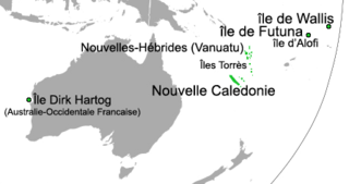
The Kerguelen Islands, also known as the Desolation Islands, are a group of islands in the sub-Antarctic constituting one of the two exposed parts of the Kerguelen Plateau, a large igneous province mostly submerged in the southern Indian Ocean. They are among the most isolated places on Earth, located more than 3,300 kilometres from Madagascar. The islands, along with Adélie Land, the Crozet Islands, Amsterdam and Saint Paul islands, and France's Scattered Islands in the Indian Ocean, are part of the French Southern and Antarctic Lands and are administered as a separate district.
The Crozet Islands are a sub-Antarctic archipelago of small islands in the southern Indian Ocean. They form one of the five administrative districts of the French Southern and Antarctic Lands.

Yves Joseph Marie de Kerguelen-Trémarec was a French Navy officer. He discovered the Kerguelen Islands during his first expedition to the southern Indian Ocean. Welcomed as a hero after his voyage and first discovery, Kerguelen fell out of favour after his second voyage and was cashiered for violating Navy regulations. He was rehabilitated during the French Revolution.
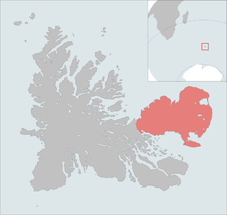
The Courbet Peninsula is a peninsula in northeastern Grande Terre Island, the main island of the subantarctic Kerguelen Archipelago, Southern Indian Ocean. In the south of the peninsula is Port-aux-Français, the principal station of the archipelago.

Anthony de la Roché was a 17th-century English maritime explorer and merchant, born in London to a French Huguenot father and an English mother, who took part in a joint venture established by English and Dutch shipowners in the Spanish port city of Cádiz in order to engage in the lucrative New World trade. During a commercial voyage between Europe and South America he was blown off course in Drake Passage, visited the island of South Georgia and sighted Clerke Rocks in 1675, thereby making the first discovery of land in the Antarctic. In doing so he crossed the Antarctic Convergence, a natural boundary of the Antarctic region that would be described a quarter of a century later by the English scientist Edmund Halley.

Louis Francois Marie Aleno de Saint Aloüarn was a French Navy officer and explorer who claimed French Western Australia.

The era of European and American voyages of scientific exploration followed the Age of Discovery and were inspired by a new confidence in science and reason that arose in the Age of Enlightenment. Maritime expeditions in the Age of Discovery were a means of expanding colonial empires, establishing new trade routes and extending diplomatic and trade relations to new territories, but with the Enlightenment scientific curiosity became a new motive for exploration to add to the commercial and political ambitions of the past. See also List of Arctic expeditions and List of Antarctic expeditions.

Raymond Rallier du Baty was a French sailor and explorer, from Lorient in Brittany, who carried out surveys of the subantarctic Kerguelen Islands in the southern Indian Ocean in the early 20th century.

The Péninsule Loranchet, also known as Presqu'île Loranchet, is a peninsula of Grande Terre, the main island of the subantarctic Kerguelen archipelago in the southern Indian Ocean.

Baie Larose, or Larose Bay in English, is a bay of Grande Terre, the main island of the subantarctic Kerguelen archipelago, a French territory in the southern Indian Ocean. It is important as a breeding site for seabirds, especially penguins.
The Îles Nuageuses comprise a group of small islands that are part of the Kerguelen archipelago, a French territory in the southern Indian Ocean. They are an important breeding spot for seabirds, especially penguins and albatrosses, and for fur seals.
Dauphine was a small 4-gun corvette of the French Navy. She is notable for the rescue operation to Tromelin Island that gave it its present name, and for taking part in the Second voyage of Kerguelen. The Baie de la Dauphine, in the Kerguelen Archipelago, is named in her honour.

Eure was a Meurthe-class aviso of the French Navy. She was launched in 1886. She is notable as having claimed territories of the Southern Indian Ocean for France, including the Kerguelen Islands in 1893. She continued to serve in the Pacific until 1901.
Louis Édouard Paul Lieutard was a French Navy officer. He notably set a formal claim for France on the Kerguelen Islands in 1893. Mont Lieutard was named in his honour.
Baie de la Dauphine is a natural harbour located on the Loranchet Peninsula, at the north-west of the island of Grande Terre in the Kerguelen Islands.

The Kerguelen Arch is a former natural arch on the island of Grande Terre in the Kerguelen Islands of the French Southern and Antarctic Lands, an archipelago in the southern Indian Ocean. Although the arch collapsed sometime between 1908 and 1913, the remaining pillars can be found on the littoral zone of the cape between Baie de l'Oiseau and Baie de la Dauphine, north of the Loranchet Peninsula. It is one of the best-known structures of the area, and its twin pillars are depicted on numerous postage stamps of the TAAF.
Charles Marc du Boisguehenneuc was a French Navy officer. He took part in the First voyage of Kerguelen and served in the War of American Independence. Boisguehenneuc Bay was named in his honour.
The Second voyage of Kerguelen was an expedition of the French Navy to the southern Indian Ocean conducted by the 64-gun ship of the line Roland, the 32-gun frigate Oiseau, and the corvette Dauphine, under Captain Kerguelen. The aims of the expedition were to confirm the findings of the First voyage of Kerguelen, returning the Kerguelen Islands and exploring what was thought to be a peninsula of a southern continent.
French Western Australia was a French territorial claim in modern-day Western Australia. It was made at Dirk Hartog Island by an expedition under French explorer Louis Aleno de St Aloüarn in 1772.
Port-Christmas is a natural and historical site on the Kerguelen Islands, located at the northern tip of the main island, on the east coast of the Loranchet Peninsula. It covers the bottom of Baie de l'Oiseau, the first shelter for sailors approaching the archipelago from the north, and is easily identifiable by the presence at the entrance of a natural arch, now collapsed, known as the Kerguelen Arch.
 Arrival of James Cook in 1776 (engraving by John Webber, 1784).
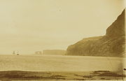 Baie de l'oiseau photographed by the aviso Eure on 2 January 1893, when France claimed the territory. The Kerguelen Arch is visible in the background.

