Ballyclough, Iowa | |
|---|---|
 Ballyclough, Iowa | |
| Coordinates: 42°25′33″N90°43′05″W / 42.42583°N 90.71806°W | |
| Country | United States |
| State | Iowa |
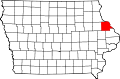
| County | Dubuque County |
| Elevation | 1,066 ft (325 m) |
| Time zone | UTC-6 (Central (CST)) |
| • Summer (DST) | UTC-5 (CDT) |
| GNIS feature ID | 454340 [1] |
Ballyclough is an unincorporated community in Dubuque County, in the U.S. state of Iowa.