Dodge Township | |
|---|---|
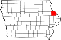
 Location in Dubuque County | |
| Coordinates: 42°25′28″N91°05′06″W / 42.42444°N 91.08500°W | |
| Country | |
| State | |
| County | Dubuque |
| Area | |
• Total | 36.59 sq mi (94.78 km2) |
| • Land | 36.6 sq mi (94.7 km2) |
| • Water | 0.031 sq mi (0.08 km2) 0.08% |
| Elevation | 1,001 ft (305 m) |
| Population (2000) | |
• Total | 1,204 |
| • Density | 33/sq mi (12.7/km2) |
| Time zone | UTC-6 (CST) |
| • Summer (DST) | UTC-5 (CDT) |
| ZIP codes | 52040, 52046, 52078 |
| GNIS feature ID | 0467717 |
Dodge Township is one of seventeen townships in Dubuque County, Iowa, United States. As of the 2000 census, its population was 1,204. [1]