Sherrill, Iowa

Last updated
Sherrill, Iowa
Sherrilliowa1.jpg
Sherrill seen from the mound[ clarification needed ]
Dubuque County Iowa Incorporated and Unincorporated areas Sherrill Highlighted.svg
Location of Sherrill, Iowa
Coordinates: 42°36′10″N90°46′56″W / 42.60278°N 90.78222°W / 42.60278; -90.78222 Coordinates: 42°36′10″N90°46′56″W / 42.60278°N 90.78222°W / 42.60278; -90.78222
Country Flag of the United States.svg  United States
State Flag of Iowa.svg  Iowa
County Dubuque
Area
[1]
  Total0.13 sq mi (0.34 km2)
  Land0.13 sq mi (0.34 km2)
  Water0.00 sq mi (0.00 km2)
Elevation
981 ft (299 m)
Population
 (2020)
  Total189
  Density1,431.82/sq mi (551.28/km2)
Time zone UTC-6 (Central (CST))
  Summer (DST) UTC-5 (CDT)
ZIP code
52073
Area code 563
FIPS code 19-72660
GNIS feature ID0461574

Sherrill is a city in Dubuque County, Iowa, United States. The population was 189 at the time of the 2020 census, up from 186 in 2000. [2]

Contents

History

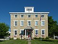
Sherrill was named for two brothers, Adam and Isaac Sherrill, and was originally called Sherrill's Mound or Mount, since the city is at the base of a prominent hill. In 1856, Peter Fries, an Austrian immigrant, built a large, stone inn at the main crossroads of the city. It was popular with newlyweds, and Jesse James and his gang were reported to have stayed there before their famous raid on Northfield, Minnesota. The structure has survived and been restored as the Black Horse Inn. Large numbers of German immigrants settled in Sherrill and the surrounding rural area in the 19th century. German Catholic (SS. Peter and Paul), German Lutheran (St. Matthew), German Methodist, and German Evangelical churches were founded and remain active. Sherrill was one of ten "Beer Towns" incorporated in Dubuque County in 1933 to ensure that the city's taverns could serve beer, under a possibly mistaken interpretation of Iowa law that licenses to dispense beer could only be granted to premises inside incorporated places. Sherrill's post office was established in 1858, with Peter Fries as postmaster. Its Zip Code is 52073.

Geography

Sherrill is located at 42°36′10″N90°46′56″W / 42.60278°N 90.78222°W / 42.60278; -90.78222 (42.602857, -90.782139). [3]

According to the United States Census Bureau, the city has a total area of 0.13 square miles (0.34 km2), all land. [4]

Demographics

Historical populations
YearPop.±%
1940 82    
1950 162+97.6%
1960 174+7.4%
1970 190+9.2%
1980 208+9.5%
1990 148−28.8%
2000 186+25.7%
2010 177−4.8%
2020 189+6.8%
Source: "U.S. Census website". United States Census Bureau . Retrieved 2020-03-28. and Iowa Data Center
Source:
U.S. Decennial Census [5] [2]

2010 census

As of the census [6] of 2010, there were 177 people, 73 households, and 54 families living in the city. The population density was 1,361.5 inhabitants per square mile (525.7/km2). There were 74 housing units at an average density of 569.2 per square mile (219.8/km2). The racial makeup of the city was 94.9% White, 2.3% African American, and 2.8% from other races. Hispanic or Latino of any race were 2.8% of the population.

There were 73 households, of which 31.5% had children under the age of 18 living with them, 63.0% were married couples living together, 6.8% had a female householder with no husband present, 4.1% had a male householder with no wife present, and 26.0% were non-families. 24.7% of all households were made up of individuals, and 15.1% had someone living alone who was 65 years of age or older. The average household size was 2.42 and the average family size was 2.89.

The median age in the city was 42.5 years. 23.7% of residents were under the age of 18; 9.1% were between the ages of 18 and 24; 19.8% were from 25 to 44; 24.2% were from 45 to 64; and 23.2% were 65 years of age or older. The gender makeup of the city was 52.5% male and 47.5% female.

2000 census

As of the census [7] of 2000, there were 186 people, 70 households, and 52 families living in the city. The population density was 1,753.9 inhabitants per square mile (677.2/km2). There were 77 housing units at an average density of 726.1 per square mile (280.3/km2). The racial makeup of the city was 100.00% White. Hispanic or Latino of any race were 2.15% of the population.

There were 70 households, out of which 31.4% had children under the age of 18 living with them, 68.6% were married couples living together, 5.7% had a female householder with no husband present, and 24.3% were non-families. 20.0% of all households were made up of individuals, and 12.9% had someone living alone who was 65 years of age or older. The average household size was 2.66 and the average family size was 3.13.

In the city, the population was spread out, with 27.4% under the age of 18, 4.8% from 18 to 24, 26.3% from 25 to 44, 22.6% from 45 to 64, and 18.8% who were 65 years of age or older. The median age was 40 years. For every 100 females, there were 104.4 males. For every 100 females age 18 and over, there were 101.5 males.

The median income for a household in the city was $38,125, and the median income for a family was $44,688. Males had a median income of $31,250 versus $20,000 for females. The per capita income for the city was $21,118. None of the families and 3.3% of the population were living below the poverty line.

Related Research Articles

<span class="mw-page-title-main">East Dubuque, Illinois</span> City in Illinois, United States

East Dubuque is a city in Jo Daviess County, Illinois, United States. The population was 1,505 at the 2020 census, down from 1,704 in 2010. East Dubuque is located alongside the Mississippi River. Across the river is the city of Dubuque, Iowa. The city limits extend along the river to the Illinois – Wisconsin border.

<span class="mw-page-title-main">Newell, Iowa</span> City in Iowa, United States

Newell is a city in Buena Vista County, Iowa, United States. The population was 906 according to the 2020 census.

<span class="mw-page-title-main">Delaware, Iowa</span> City in Iowa, United States

Delaware is a city in Delaware County, Iowa, United States. The population was 142 at the time of the 2020 census.

<span class="mw-page-title-main">Earlville, Iowa</span> City in Iowa, United States

Earlville is a city in Delaware County, Iowa, United States. The population was 716 at the time of the 2020 census.

<span class="mw-page-title-main">Balltown, Iowa</span> City in Iowa, United States

Balltown is a city in Dubuque County, Iowa, United States. It is part of the Dubuque, Iowa Metropolitan Statistical Area. The population was 79 at the 2020 census, up from 73 in 2000. Balltown is home to Breitbach's Country Dining, Iowa's oldest restaurant and bar, which was founded in 1852 and twice rebuilt by the community, following its destruction by fire in 2007 and 2008.

<span class="mw-page-title-main">Bankston, Iowa</span> City in Iowa, United States

Bankston is a city in Dubuque County, Iowa, United States. It is part of the 'Dubuque, Iowa Metropolitan Statistical Area'. The population was 23 at the 2020 census, down from 27 in 2000.

<span class="mw-page-title-main">Bernard, Iowa</span> City in Iowa, United States

Bernard is a city in Dubuque County, Iowa, United States. The population was 114 in the 2020 census, an increase from the 97 population in 2000. Bernard is part of the Dubuque, Iowa Metropolitan Statistical Area.

<span class="mw-page-title-main">Centralia, Iowa</span> City in Iowa, United States

Centralia is a city in Dubuque County, Iowa, United States. It is part of the Dubuque, Iowa Metropolitan Statistical Area. The population was 116 at the 2020 census, up 15 persons since the 2000 census and down 18 from the 2010.

<span class="mw-page-title-main">Durango, Iowa</span> City in Iowa, United States

Durango is a city in Dubuque County, Iowa, United States. It is part of the Dubuque, Iowa Metropolitan Statistical Area. The population was 20 at the time of the 2020 census, down from 24 in 2000.

<span class="mw-page-title-main">Epworth, Iowa</span> City in Iowa, United States

Epworth is a city in Dubuque County, Iowa, United States. It is part of the Dubuque, Iowa Metropolitan Statistical Area. The population was 2,023 at the 2020 census, up from 1,428 in 2000.

<span class="mw-page-title-main">Farley, Iowa</span> City in Iowa, United States

Farley is a city in Dubuque County, Iowa, United States. It is part of the Dubuque, Iowa Metropolitan Statistical Area. The population was 1,766 at the time of the 2020 census, up from 1,334 in 2000. Farley is the seventh-largest town in Dubuque County, recently passed by Peosta, Iowa.

<span class="mw-page-title-main">Graf, Iowa</span> City in Iowa, United States

Graf is a city in Dubuque County, Iowa, United States. It is part of the 'Dubuque, Iowa Metropolitan Statistical Area'. The population was 76 at the time of the 2020 census, up from 73 in 2000.

<span class="mw-page-title-main">Holy Cross, Iowa</span> City in Iowa, United States

Holy Cross is a city in Dubuque County, Iowa, United States. It is part of the Dubuque, Iowa Metropolitan Statistical Area. The population was 356 at the time of the 2020 census, down from 399 in 2000.

<span class="mw-page-title-main">Luxemburg, Iowa</span> City in Iowa, United States

Luxemburg is a city in Dubuque County, Iowa, United States. It is part of the Dubuque, Iowa Metropolitan Statistical Area. The population was 245 at the time of the 2020 census, down from 246 in 2000. The White Pine Hollow State Forest is located four miles to the northwest of Luxemburg.

<span class="mw-page-title-main">New Vienna, Iowa</span> City in Iowa, United States

New Vienna is a city in Dubuque County, Iowa, United States. It is part of the Dubuque, Iowa Metropolitan Statistical Area. The population was 382 at the time of the 2020 census, down from 400 in 2000. New Vienna is the home to the Saint Boniface Catholic Church. The city promotes itself with the slogan The eNVy of Iowa.

<span class="mw-page-title-main">Rickardsville, Iowa</span> City in Iowa, United States

Rickardsville is a city in Dubuque County, Iowa, United States. The population was 202 at the time of the 2020 census, up from 191 in 2000.

<span class="mw-page-title-main">Sageville, Iowa</span> City in Iowa, United States

Sageville is a city in Dubuque County, Iowa, United States. The population was 95 at the time of the 2020 census, down from 203 in 2000.

<span class="mw-page-title-main">Worthington, Iowa</span> City in Iowa, United States

Worthington is a city in Dubuque County, Iowa, United States. The population was 382 at the time of the 2020 census, up from 381 in 2000. Iowa Highway 136 passes through Worthington, which is situated north of Cascade and south of Dyersville.

<span class="mw-page-title-main">St. Donatus, Iowa</span> City in Iowa, United States

St. Donatus is a city in Jackson County, Iowa, United States. The population was 120 at the time of the 2020 census. St. Donatus is known for its status as a Luxembourger village, with historic architecture and views along U.S. Route 52. It is the home of a historic Catholic church, which is dedicated to Saint Donatus of Muenstereifel, the town's namesake. It was formerly named Tete Des Morts, which is the name of a creek that flows through the village.

<span class="mw-page-title-main">Zwingle, Iowa</span> City in Iowa, United States

Zwingle is a city in Dubuque and Jackson counties in the U.S. state of Iowa. The population was 84 at the time of the 2020 census, down from 100 in 2000.

References

  1. "2020 U.S. Gazetteer Files". United States Census Bureau. Retrieved March 16, 2022.
  2. 1 2 "2020 Census State Redistricting Data". census.gov. United states Census Bureau. Retrieved 12 August 2021.
  3. "US Gazetteer files: 2010, 2000, and 1990". United States Census Bureau. 2011-02-12. Retrieved 2011-04-23.
  4. "US Gazetteer files 2010". United States Census Bureau. Archived from the original on 2012-01-25. Retrieved 2012-05-11.
  5. "Census of Population and Housing". Census.gov. Retrieved June 4, 2015.
  6. "U.S. Census website". United States Census Bureau . Retrieved 2012-05-11.
  7. "U.S. Census website". United States Census Bureau . Retrieved 2008-01-31.

Further reading

|