Farley is home to a 3/8 mile dirt race track, 300 Raceway.[3]
History
Farley got its start in the 1850s, following construction of the Dubuque and Sioux City Railroad through that territory.[4] Farley was named for the superintendent of the Sioux City Railroad.[5]
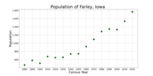
The population of Farley, Iowa from US census data
2020 census
As of the census of 2020,[10] there were 1,766 people, 654 households, and 467 families residing in the city. The population density was 1,091.3 inhabitants per square mile (421.4/km2). There were 678 housing units at an average density of 419.0 per square mile (161.8/km2). The racial makeup of the city was 96.1% White, 0.2% Black or African American, 0.0% Native American, 0.2% Asian, 0.0% Pacific Islander, 2.0% from other races and 1.4% from two or more races. Hispanic or Latino persons of any race comprised 3.5% of the population.
Of the 654 households, 34.1% of which had children under the age of 18 living with them, 56.1% were married couples living together, 6.7% were cohabitating couples, 19.6% had a female householder with no spouse or partner present and 17.6% had a male householder with no spouse or partner present. 28.6% of all households were non-families. 23.7% of all households were made up of individuals, 6.3% had someone living alone who was 65 years old or older.
The median age in the city was 33.7 years. 30.7% of the residents were under the age of 20; 7.5% were between the ages of 20 and 24; 26.5% were from 25 and 44; 23.0% were from 45 and 64; and 12.3% were 65 years of age or older. The gender makeup of the city was 51.0% male and 49.0% female.
2010 census
As of the census[11] of 2010, there were 1,537 people, 575 households, and 425 families residing in the city. The population density was 830.8 inhabitants per square mile (320.8/km2). There were 586 housing units at an average density of 316.8 per square mile (122.3/km2). The racial makeup of the city was 99.3% White, 0.1% African American, 0.3% from other races, and 0.3% from two or more races. Hispanic or Latino of any race were 1.0% of the population.
There were 575 households, of which 40.2% had children under the age of 18 living with them, 61.4% were married couples living together, 8.5% had a female householder with no husband present, 4.0% had a male householder with no wife present, and 26.1% were non-families. 22.1% of all households were made up of individuals, and 10.8% had someone living alone who was 65 years of age or older. The average household size was 2.67 and the average family size was 3.15.
The median age in the city was 33.8 years. 29.7% of residents were under the age of 18; 7.9% were between the ages of 18 and 24; 28.1% were from 25 to 44; 23.7% were from 45 to 64; and 10.9% were 65 years of age or older. The gender makeup of the city was 49.3% male and 50.7% female.
2000 census
As of the census[12] of 2000, there were 1,334 people, 491 households, and 365 families residing in the city. The population density was 948.8 inhabitants per square mile (366.3/km2). There were 513 housing units at an average density of 364.9 per square mile (140.9/km2). The racial makeup of the city was 98.88% White, 0.15% African American, 0.30% Native American, 0.45% Asian, 0.15% from other races, and 0.07% from two or more races. Hispanic or Latino of any race were 0.97% of the population.
There were 491 households, out of which 39.9% had children under the age of 18 living with them, 63.5% were married couples living together, 7.7% had a female householder with no husband present, and 25.5% were non-families. 23.8% of all households were made up of individuals, and 12.4% had someone living alone who was 65 years of age or older. The average household size was 2.71 and the average family size was 3.25.
30.3% are under the age of 18, 7.9% from 18 to 24, 30.2% from 25 to 44, 18.9% from 45 to 64, and 12.7% who were 65 years of age or older. The median age was 32 years. For every 100 females, there were 99.1 males. For every 100 females age 18 and over, there were 96.6 males.
The median income for a household in the city was $41,333, and the median income for a family was $48,854. Males had a median income of $32,328 versus $20,476 for females. The per capita income for the city was $17,186. About 4.5% of families and 5.3% of the population were below the poverty line, including 6.0% of those under age 18 and 5.7% of those age 65 or over.
Like many other rural communities in Iowa, Farley also has a private school. Seton Catholic Elementary School- Farley is one of three buildings that comprise Seton Catholic Elementary School, and is affiliated with the Roman Catholic Archdiocese of Dubuque. For grades 1–2, students go to the building in Epworth, for grades 3–5, students attend the building in Peosta, Iowa, and for grades 6–8, students go to the building in Farley. For high school, parochial students attend Beckman High School in Dyersville, Iowa or Wahlert High School in Dubuque, Iowa.
This page is based on this Wikipedia article Text is available under the CC BY-SA 4.0 license; additional terms may apply. Images, videos and audio are available under their respective licenses.


