Bennettsville, Iowa | |
|---|---|
 Bennettsville, Iowa | |
| Coordinates: 42°21′36″N90°43′41″W / 42.36000°N 90.72806°W | |
| Country | United States |
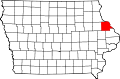
| State | Iowa |
| County | Dubuque County |
| Time zone | UTC-6 (Central (CST)) |
| • Summer (DST) | UTC-5 (CDT) |
| Area code | 712 |
| GNIS feature ID | 464164 [1] |
Bennettsville (also known as Bennettville) was an unincorporated community in Dubuque County, in the U.S. state of Iowa.