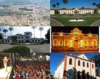
Cruz das Almas is a municipality, in the state of Bahia, in Brazil. Founded in 1897, it is home to the Federal University of Recôncavo da Bahia and is one of the main cities of Bahia.

Morro do Chapéu is a municipality in the Brazilian state of Bahia, 386 km northwest of its capital, Salvador, 1012 meters above the sea level, because of which it is one of the coolest towns in Bahia, with temperatures occasionally falling below 10 °C in the winter. Its estimated population in 2020 is 35,440.
Mata Verde is a Brazilian municipality located in the state of Minas Gerais. As of 2020 the population was 8,644 and the area was 230 km2 (89 sq mi). The elevation is 865 m (2,838 ft).

Barra is a municipality in Bahia, Brazil. Barra covers 11,422.537 km2 (4,410.266 sq mi), and has a population of 53,910 with a population density of 4.3 inhabitants per square kilometer.

Antônio Cardoso is a municipality in the state of Bahia in the North-East region of Brazil. Its name is a tribute to Colonel Antônio Cardoso de Sousa (1848–1932), the former owner of extensive properties and a figure with political and economic power. A namesake grandson was the first mayor of the municipality. The occupation of the territory of Antônio Cardoso began in the 17th century, with Jesuits who built a chapel in honor of Saint Stephen. The former inhabitants were the Paiaiá indigenous people. As of 2022, its population was divided into 55% Black, 40% Pardo, 4.9% White, and 0.1% Indigenous and 0.1% Asian.

Pedrão is a municipality in the state of Bahia in the North-East region of Brazil.

América Dourada is a municipality in the state of Bahia in the North-East region of Brazil.

Umburanas is a municipality in the state of Bahia in the North-East region of Brazil. Umburanas covers 1,775.633 km2 (685.576 sq mi), and has a population of 19,402 with a population density of 10.2 inhabitants per square kilometer. The municipality is located within the caatinga ecoregion. Umburanas borders on five municipalities: Ourolândia, Mirangaba, Campo Formoso, Morro do Chapéu, and Sento Sé, all in the state of Bahia.

Igaporã is a municipality in the state of Bahia in the North-East region of Brazil. It is located in the semi-arid sertão region in the interior of the state. It had an estimated 15,650 inhabitants as of 2020. It covers 836.586 square kilometres (323.008 sq mi) and is 682 kilometres (424 mi) from the state capital, Salvador. It is located in the southwest region of Bahia close to the Chapada Diamantina, a mountainous region of the state. Igaporã became an independent municipality by the State Law 556 of March, 25th 1953, and its territory was dismembered from the neighboring municipality of Caetité.
Itapetinga, Bahia, Brazil is a municipality in the state of Bahia in the North-East region of Brazil. Its population in 2020, according to estimates by the IBGE, was 76,795, so it is the 24th most populous municipality of Bahia.
Cravolândia is a municipality in the state of Bahia in the North-East region of Brazil. Cravolândia covers 182.585 km2 (70.496 sq mi), and has a population of 5,351 with a population density of 31 inhabitants per square kilometer. It borders the municipalities of Santa Inês, Itaquara, Ubaíra and Wenceslau Guimarães. Cravolândia is located 317 kilometres (197 mi) from Salvador, the state capital of Bahia, and is connected to Salvador by federal highways BR-116 and BR-101.
Livramento de Nossa Senhora is a municipality in the state of Bahia in the North-East region of Brazil.

Itaguaçu da Bahia is a municipality in the state of Bahia in the North-East region of Brazil. It covers 4,451.270 km2 (1,718.645 sq mi), and has a population of 14,542 with a population density of 3.3 inhabitants per square kilometer.

Remanso is located in −9.62, −42 municipality in the state of Bahia in the North-East region of Brazil.

Almadina, Bahia is a municipality in the state of Bahia in the North-East region of Brazil. Almadina covers 245.27 km2 (94.70 sq mi), and has a population of 5,366 with a population density of 25 inhabitants per square kilometer.

Campo Alegre de Lourdes is a municipality in the state of Bahia in the North-East region of Brazil. Campo Alegre de Lourdes covers 2,781.170 km2 (1,073.816 sq mi), and has a population of 28,820 with a population density of 11 inhabitants per square kilometer. It is located at the north of the state on the border of Bahia and Piauí.

Feira da Mata is a municipality in the state of Bahia in the North-East region of Brazil. Feira da Mata covers 1,176.105 km2 (454.097 sq mi), and has a population of 5,661 with a population density of 5 inhabitants per square kilometer. It was originally part of Carinhanha, but became an independent municipality in 1989.
Santa Inês is a municipality in the state of Bahia in the North-East region of Brazil.

Serra do Ramalho is a municipality in the state of Bahia in the North-East region of Brazil.


